<< Our Photo Pages >> Garth Hill - Round Barrow(s) in Wales in South Glamorgan
Submitted by templar on Friday, 03 September 2004 Page Views: 14745
Neolithic and Bronze AgeSite Name: Garth HillCountry: Wales
NOTE: This site is 2.996 km away from the location you searched for.
County: South Glamorgan Type: Round Barrow(s)
Nearest Town: Cardiff Nearest Village: Gwaelod-y-garth
Map Ref: ST103835
Latitude: 51.543242N Longitude: 3.294875W
Condition:
| 5 | Perfect |
| 4 | Almost Perfect |
| 3 | Reasonable but with some damage |
| 2 | Ruined but still recognisable as an ancient site |
| 1 | Pretty much destroyed, possibly visible as crop marks |
| 0 | No data. |
| -1 | Completely destroyed |
| 5 | Superb |
| 4 | Good |
| 3 | Ordinary |
| 2 | Not Good |
| 1 | Awful |
| 0 | No data. |
| 5 | Can be driven to, probably with disabled access |
| 4 | Short walk on a footpath |
| 3 | Requiring a bit more of a walk |
| 2 | A long walk |
| 1 | In the middle of nowhere, a nightmare to find |
| 0 | No data. |
| 5 | co-ordinates taken by GPS or official recorded co-ordinates |
| 4 | co-ordinates scaled from a detailed map |
| 3 | co-ordinates scaled from a bad map |
| 2 | co-ordinates of the nearest village |
| 1 | co-ordinates of the nearest town |
| 0 | no data |
Internal Links:
External Links:
")
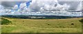
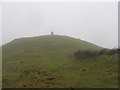
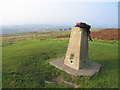
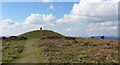
The largest mound has a triangulation point on top of it and is a great place to view the entire site.
An interpretation board is situated just to the south of the main mound but it doesn't add much to what can be seen from the ground. A sixth mound on the far eastern side of the hill is actually a Second World War gun emplacement.
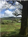
Access can be gained by driving to the Gwaelod-y-garth public house and following the lane that runs behind the pub up a very step hill and then along the southern flank of the hill. Just before the hamlet of Soar, there is a layby and a driveway. Park here and walk up the drive branching right immediately up the trail to the top; it's just under 1 kilometre.
You may be viewing yesterday's version of this page. To see the most up to date information please register for a free account.
")
")
")
")
Do not use the above information on other web sites or publications without permission of the contributor.
Nearby Images from Geograph Britain and Ireland:
©2018(licence)
©2019(licence)
©2010(licence)
©2013(licence)
©2016(licence)
The above images may not be of the site on this page, they are loaded from Geograph.
Please Submit an Image of this site or go out and take one for us!
Click here to see more info for this site
Nearby sites
Key: Red: member's photo, Blue: 3rd party photo, Yellow: other image, Green: no photo - please go there and take one, Grey: site destroyed
Download sites to:
KML (Google Earth)
GPX (GPS waypoints)
CSV (Garmin/Navman)
CSV (Excel)
To unlock full downloads you need to sign up as a Contributory Member. Otherwise downloads are limited to 50 sites.
Turn off the page maps and other distractions
Nearby sites listing. In the following links * = Image available
1.6km E 84° Taffs Well* Holy Well or Sacred Spring (ST1192683638)
1.8km S 178° Ffynnoncattwg* Holy Well or Sacred Spring (ST10348165)
2.6km SSE 166° Llwynda-ddu Hillfort (ST10878100)
2.7km ESE 123° Lesser Garth Cave* Cave or Rock Shelter (ST125820)
2.8km SSW 200° Craig-y-Parc Ancient Village or Settlement (ST09298084)
2.9km WSW 241° Cae'rarfau* Chambered Tomb (ST0772582144)
4.7km SE 137° Radyr Woods Burnt Mound* Artificial Mound (ST13438003)
4.9km E 98° Wennalt Camp Ancient Village or Settlement (ST15208275)
5.2km SE 137° Pistyll Golau Holy Well or Sacred Spring (ST13787962)
5.2km S 182° Sant-Y-Nyll Round Barrow(s) (ST10077829)
6.1km NE 55° Gorsedd Stones (Caerphilly)* Modern Stone Circle etc (ST15388687)
6.3km NW 305° Tarren Deusant* Holy Well or Sacred Spring (ST05208721)
6.5km SSE 166° Museum of Welsh Life, St Fagans* Museum (ST117772)
6.6km SSE 165° St Fagan's Well Holy Well or Sacred Spring (ST11917712)
6.9km NNW 341° Carreg Siglio* Modern Stone Circle etc (ST082901)
7.2km NNW 340° Coed-Pen-Maen Common* Ring Cairn (ST07989031)
7.6km SE 135° St Teilo's Well, Llandaff* Holy Well or Sacred Spring (ST15567805)
8.1km NNE 24° The Bryn Cairn (ST13689082)
8.2km NNE 23° The Bryn Earthwork Ring Cairn (ST13619105)
8.4km NNE 28° Bryn Owen Farm Cairns Cairn (ST144908)
8.5km N 0° Carneddi Llwydion* Round Cairn (ST105920)
8.5km NNE 17° Waun Deiliaid Ring Cairn (ST12939162)
8.6km SSW 206° Ffynnon Deilo* Holy Well or Sacred Spring (ST0633975904)
8.6km W 272° Llanharan Beacons* Cairn (ST0170783980)
8.8km N 3° Ffos-yr-Haidal 1, Mynydd Eglwysilan* Rock Art (ST10899224)
View more nearby sites and additional images


 We would like to know more about this location. Please feel free to add a brief description and any relevant information in your own language.
 Wir möchten mehr über diese Stätte erfahren. Bitte zögern Sie nicht, eine kurze Beschreibung und relevante Informationen in Deutsch hinzuzufügen.
 Nous aimerions en savoir encore un peu sur les lieux. S'il vous plaît n'hesitez pas à ajouter une courte description et tous les renseignements pertinents dans votre propre langue.
 Quisieramos informarnos un poco más de las lugares. No dude en añadir una breve descripción y otros datos relevantes en su propio idioma.