<< Our Photo Pages >> King's Stone (Perth) - Standing Stone (Menhir) in Scotland in Perth and Kinross
Submitted by BigSweetie on Thursday, 25 March 2004 Page Views: 8213
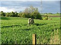
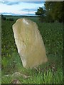
Neolithic and Bronze AgeSite Name: King's Stone (Perth)Country: Scotland County: Perth and Kinross Type: Standing Stone (Menhir)
Nearest Town: Perth Nearest Village: Luncarty
Map Ref: NO09712828 Landranger Map Number: 52
Latitude: 56.438032N Longitude: 3.465926W
Condition:
| 5 | Perfect |
| 4 | Almost Perfect |
| 3 | Reasonable but with some damage |
| 2 | Ruined but still recognisable as an ancient site |
| 1 | Pretty much destroyed, possibly visible as crop marks |
| 0 | No data. |
| -1 | Completely destroyed |
| 5 | Superb |
| 4 | Good |
| 3 | Ordinary |
| 2 | Not Good |
| 1 | Awful |
| 0 | No data. |
| 5 | Can be driven to, probably with disabled access |
| 4 | Short walk on a footpath |
| 3 | Requiring a bit more of a walk |
| 2 | A long walk |
| 1 | In the middle of nowhere, a nightmare to find |
| 0 | No data. |
| 5 | co-ordinates taken by GPS or official recorded co-ordinates |
| 4 | co-ordinates scaled from a detailed map |
| 3 | co-ordinates scaled from a bad map |
| 2 | co-ordinates of the nearest village |
| 1 | co-ordinates of the nearest town |
| 0 | no data |
Be the first person to rate this site - see the 'Contribute!' box in the right hand menu.
Internal Links:
External Links:
 (PID:281121)")
Have you visited this site? Please add a comment below.
You may be viewing yesterday's version of this page. To see the most up to date information please register for a free account.
Do not use the above information on other web sites or publications without permission of the contributor.
coldrum has found this location on Google Street View:
Nearby Images from Geograph Britain and Ireland:
©2005(licence)

©2024(licence)
©2009(licence)
©2019(licence)
©2022(licence)
The above images may not be of the site on this page, they are loaded from Geograph.
Please Submit an Image of this site or go out and take one for us!
Click here to see more info for this site
Nearby sites
Key: Red: member's photo, Blue: 3rd party photo, Yellow: other image, Green: no photo - please go there and take one, Grey: site destroyed
Download sites to:
KML (Google Earth)
GPX (GPS waypoints)
CSV (Garmin/Navman)
CSV (Excel)
To unlock full downloads you need to sign up as a Contributory Member. Otherwise downloads are limited to 50 sites.
Turn off the page maps and other distractions
Nearby sites listing. In the following links * = Image available
348m WNW 296° Denmarkfield Farm Standing Stone (Menhir) (NO09402844)
719m SW 235° Broxy Kennels* Hillfort (NO09112788)
1.8km E 98° Scone Cursus Cursus (NO11532797)
2.0km E 96° Scone Cursus Cursus (NO11712803)
2.2km NNW 336° Cramflat* Standing Stone (Menhir) (NO0885530322)
3.0km SSW 198° Hunting Tower Cursus (NO087254)
3.1km NNE 23° Colen* Stone Circle (NO110311)
3.4km NNW 332° Gellybank* Standing Stones (NO082313)
3.7km SSW 208° Mains Of Huntingtower Stone Circle (NO079251)
3.8km W 277° Moneydie* Stone Circle (NO059288)
3.9km N 356° Overbenchil* Standing Stone (Menhir) (NO095322)
4.0km ESE 116° Sandy Road* Stone Circle (NO1327526463)
4.0km ESE 116° Sandy Road East Stone Circle (NO13282646)
4.1km NE 41° Druids Seat* Stone Circle (NO12483132)
4.3km NNW 343° Newmill souterrain* Souterrain (Fogou, Earth House) (NO08513239)
4.4km SW 218° Huntingtower Cairn (NO069249)
4.9km NE 55° Williamston Stone Circle (NO138310)
5.0km SSE 153° Inchyra* Class I Pictish Symbol Stone (NO119238)
5.0km SSE 153° Perth Museum and Art Gallery* Museum (NO119238)
5.0km SE 143° Murray Royal Hospital* Standing Stone (Menhir) (NO127242)
5.1km NNW 336° Loak Court Hill Round Barrow(s) (NO07733301)
5.2km NNW 335° Loak Stone* Standing Stone (Menhir) (NO07573305)
5.5km ENE 58° Tammieteeth* Cairn (NO14403109)
5.5km NW 312° Cowford Standing Stone (Menhir) (NO05633205)
5.6km NE 51° Blackfaulds* Stone Circle (NO14133167)
View more nearby sites and additional images


 We would like to know more about this location. Please feel free to add a brief description and any relevant information in your own language.
 Wir möchten mehr über diese Stätte erfahren. Bitte zögern Sie nicht, eine kurze Beschreibung und relevante Informationen in Deutsch hinzuzufügen.
 Nous aimerions en savoir encore un peu sur les lieux. S'il vous plaît n'hesitez pas à ajouter une courte description et tous les renseignements pertinents dans votre propre langue.
 Quisieramos informarnos un poco más de las lugares. No dude en añadir una breve descripción y otros datos relevantes en su propio idioma.