<< Our Photo Pages >> Overbenchil - Standing Stone (Menhir) in Scotland in Perth and Kinross
Submitted by Mehir on Monday, 02 September 2002 Page Views: 10412
Neolithic and Bronze AgeSite Name: Overbenchil Alternative Name: Over BenchilCountry: Scotland County: Perth and Kinross Type: Standing Stone (Menhir)
Nearest Village: Stanley
Map Ref: NO095322 Landranger Map Number: 52
Latitude: 56.473198N Longitude: 3.47069W
Condition:
| 5 | Perfect |
| 4 | Almost Perfect |
| 3 | Reasonable but with some damage |
| 2 | Ruined but still recognisable as an ancient site |
| 1 | Pretty much destroyed, possibly visible as crop marks |
| 0 | No data. |
| -1 | Completely destroyed |
| 5 | Superb |
| 4 | Good |
| 3 | Ordinary |
| 2 | Not Good |
| 1 | Awful |
| 0 | No data. |
| 5 | Can be driven to, probably with disabled access |
| 4 | Short walk on a footpath |
| 3 | Requiring a bit more of a walk |
| 2 | A long walk |
| 1 | In the middle of nowhere, a nightmare to find |
| 0 | No data. |
| 5 | co-ordinates taken by GPS or official recorded co-ordinates |
| 4 | co-ordinates scaled from a detailed map |
| 3 | co-ordinates scaled from a bad map |
| 2 | co-ordinates of the nearest village |
| 1 | co-ordinates of the nearest town |
| 0 | no data |
Be the first person to rate this site - see the 'Contribute!' box in the right hand menu.
Internal Links:
External Links:
")
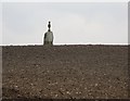
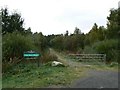
This stone stands next to Overbenchil farm house near Stanley in Perthshire. This stone for some horrific reason had sundial placed on top at least 100 years ago and has several iron nails in some of the cracks.
The stone itself is stunning, standing 8ft tall and about 3ft broad. As with nearby Gellybank the stone used is quartzose schist and has a spectacular display of large crystals.
Permission should be sought from the very nice gent who lives in the farmhouse.
You may be viewing yesterday's version of this page. To see the most up to date information please register for a free account.
Do not use the above information on other web sites or publications without permission of the contributor.
coldrum has found this location on Google Street View:
Nearby Images from Geograph Britain and Ireland:
©2007(licence)
©2007(licence)
©2013(licence)
©2011(licence)
©2007(licence)
The above images may not be of the site on this page, they are loaded from Geograph.
Please Submit an Image of this site or go out and take one for us!
Click here to see more info for this site
Nearby sites
Key: Red: member's photo, Blue: 3rd party photo, Yellow: other image, Green: no photo - please go there and take one, Grey: site destroyed
Download sites to:
KML (Google Earth)
GPX (GPS waypoints)
CSV (Garmin/Navman)
CSV (Excel)
To unlock full downloads you need to sign up as a Contributory Member. Otherwise downloads are limited to 50 sites.
Turn off the page maps and other distractions
Nearby sites listing. In the following links * = Image available
1.0km W 280° Newmill souterrain* Souterrain (Fogou, Earth House) (NO08513239)
1.6km SW 234° Gellybank* Standing Stones (NO082313)
1.9km SE 125° Colen* Stone Circle (NO110311)
1.9km WNW 293° Loak Court Hill Round Barrow(s) (NO07733301)
2.0km SSW 198° Cramflat* Standing Stone (Menhir) (NO0885530322)
2.1km WNW 293° Loak Stone* Standing Stone (Menhir) (NO07573305)
3.1km ESE 105° Druids Seat* Stone Circle (NO12483132)
3.8km S 180° Denmarkfield Farm Standing Stone (Menhir) (NO09402844)
3.9km W 267° Cowford Standing Stone (Menhir) (NO05633205)
3.9km S 176° King's Stone (Perth)* Standing Stone (Menhir) (NO09712828)
4.3km S 184° Broxy Kennels* Hillfort (NO09112788)
4.5km ESE 104° Williamston Stone Circle (NO138310)
4.5km WNW 299° Pitsundry* Stone Circle (NO0558834454)
4.6km E 95° Blackfaulds* Stone Circle (NO14133167)
4.7km SSE 153° Scone Cursus Cursus (NO11532797)
4.7km SSE 151° Scone Cursus Cursus (NO11712803)
4.9km SW 225° Moneydie* Stone Circle (NO059288)
5.0km ESE 102° Tammieteeth* Cairn (NO14403109)
5.2km E 82° Wolfhill* Stone Circle (NO147328)
5.3km E 82° Craigmakerran* Standing Stones (NO1477832850)
6.4km N 6° Murthly* Stone Circle (NO10273852)
6.4km E 94° Witches' Stone, St Martins* Standing Stone (Menhir) (NO15923160)
6.6km E 98° St. Martins* Stone Circle (NO160312)
6.6km NE 51° Cargill Symbol Stone Class I Pictish Symbol Stone (NO14773623)
6.7km E 100° Brownies Knowe Stone Circle (NO16063092)
View more nearby sites and additional images


 We would like to know more about this location. Please feel free to add a brief description and any relevant information in your own language.
 Wir möchten mehr über diese Stätte erfahren. Bitte zögern Sie nicht, eine kurze Beschreibung und relevante Informationen in Deutsch hinzuzufügen.
 Nous aimerions en savoir encore un peu sur les lieux. S'il vous plaît n'hesitez pas à ajouter une courte description et tous les renseignements pertinents dans votre propre langue.
 Quisieramos informarnos un poco más de las lugares. No dude en añadir una breve descripción y otros datos relevantes en su propio idioma.