<< Our Photo Pages >> Ffynnon Beuno (Caves) - Cave or Rock Shelter in Wales in Denbighshire
Submitted by TimPrevett on Monday, 14 October 2002 Page Views: 13067
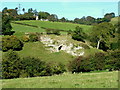
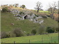
Natural PlacesSite Name: Ffynnon Beuno (Caves)Country: Wales County: Denbighshire Type: Cave or Rock Shelter
Nearest Town: St Asaph Nearest Village: Sodom
Map Ref: SJ0849972500 Landranger Map Number: 116
Latitude: 53.241610N Longitude: 3.372562W
Condition:
| 5 | Perfect |
| 4 | Almost Perfect |
| 3 | Reasonable but with some damage |
| 2 | Ruined but still recognisable as an ancient site |
| 1 | Pretty much destroyed, possibly visible as crop marks |
| 0 | No data. |
| -1 | Completely destroyed |
| 5 | Superb |
| 4 | Good |
| 3 | Ordinary |
| 2 | Not Good |
| 1 | Awful |
| 0 | No data. |
| 5 | Can be driven to, probably with disabled access |
| 4 | Short walk on a footpath |
| 3 | Requiring a bit more of a walk |
| 2 | A long walk |
| 1 | In the middle of nowhere, a nightmare to find |
| 0 | No data. |
| 5 | co-ordinates taken by GPS or official recorded co-ordinates |
| 4 | co-ordinates scaled from a detailed map |
| 3 | co-ordinates scaled from a bad map |
| 2 | co-ordinates of the nearest village |
| 1 | co-ordinates of the nearest town |
| 0 | no data |
Internal Links:
External Links:
I have visited· I would like to visit
TimPrevett has visited here
 (PID:25452)")
A mammoth bone dated to 16,000 BC found. Tools have been dated to around 36,000 BC, and also between 28 - 26,000 BC. One assumes that the cave has been linked as a hermitage for the early mediaeval St Beuno by the attribution of his name.
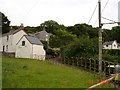
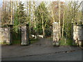
This is the back garden of the Starters Restaurant, and permission needs to be obtained first for a visit.
You may be viewing yesterday's version of this page. To see the most up to date information please register for a free account.
Do not use the above information on other web sites or publications without permission of the contributor.
Nearby Images from Geograph Britain and Ireland:
©2005(licence)
©2005(licence)
©2007(licence)
©2007(licence)
©2007(licence)
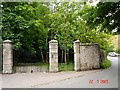
The above images may not be of the site on this page, they are loaded from Geograph.
Please Submit an Image of this site or go out and take one for us!
Click here to see more info for this site
Nearby sites
Key: Red: member's photo, Blue: 3rd party photo, Yellow: other image, Green: no photo - please go there and take one, Grey: site destroyed
Download sites to:
KML (Google Earth)
GPX (GPS waypoints)
CSV (Garmin/Navman)
CSV (Excel)
To unlock full downloads you need to sign up as a Contributory Member. Otherwise downloads are limited to 50 sites.
Turn off the page maps and other distractions
Nearby sites listing. In the following links * = Image available
60m W 270° Cae Gwyn* Cave or Rock Shelter (SJ0843972501)
282m SW 224° St Beuno's Well (Tremeirchion)* Holy Well or Sacred Spring (SJ083723)
729m NNE 26° Penuchaf Cairn (SJ08837315)
1.1km E 92° Cefn Du Ancient Village or Settlement (SJ0956272450)
1.8km N 5° Moel Maen Efa* Barrow Cemetery (SJ087743)
2.0km SSE 148° Moel-y-Gaer (Bodfari)* Hillfort (SJ09527080)
2.1km NE 53° Coed Bron Fawr* Barrow Cemetery (SJ10167372)
3.7km NNE 12° Criafol* Round Barrow(s) (SJ09317611)
3.9km NNE 16° Pany Y Dulath Round Barrow(s) (SJ09677624)
4.1km NNW 347° Llyn-Y-Gorseddau 1 Round Barrow(s) (SJ07657651)
4.1km NNW 348° Llyn-Y-Gorseddau 2 Round Barrow(s) (SJ07687657)
4.2km NNW 347° Llyn-Y-Gorseddau 3 Round Barrow(s) (SJ07647662)
4.3km NE 36° Traveller's Inn* Round Barrow(s) (SJ111759)
4.5km NNE 20° Hendre Bach Round Barrow(s) (SJ10137671)
4.6km WNW 288° Ysgol Glan Clwyd Modern Circle* Modern Stone Circle etc (SJ0412074000)
4.8km NNW 348° Aelwyd Uchaf (Cottage) Barrows Round Barrow(s) (SJ0758577185)
5.3km NNW 343° Marion Bach 1 Round Barrow(s) (SJ07057759)
5.5km NNW 345° Marion Bach 2 Round Barrow(s) (SJ07217782)
5.5km NNW 348° Marian Ffrith Hillfort (SJ0746877947)
5.7km N 3° Cae Bryn Round Barrow(s) (SJ08917821)
5.7km WSW 254° Ffynnon Fair (Trefnant)* Holy Well or Sacred Spring (SJ02927107)
6.1km NE 55° Ffrith-Y-Garreg-Wen* Round Barrow(s) (SJ13587589)
6.3km SW 236° Plas Heaton Cave Cave or Rock Shelter (SJ03206911)
6.4km NNW 339° Moel Hiraddug* Hillfort (SJ063785)
6.5km WSW 251° Cefn-Yr-Ogof Cave or Rock Shelter (SJ023705)
View more nearby sites and additional images


 We would like to know more about this location. Please feel free to add a brief description and any relevant information in your own language.
 Wir möchten mehr über diese Stätte erfahren. Bitte zögern Sie nicht, eine kurze Beschreibung und relevante Informationen in Deutsch hinzuzufügen.
 Nous aimerions en savoir encore un peu sur les lieux. S'il vous plaît n'hesitez pas à ajouter une courte description et tous les renseignements pertinents dans votre propre langue.
 Quisieramos informarnos un poco más de las lugares. No dude en añadir una breve descripción y otros datos relevantes en su propio idioma.