<< Text Pages >> Mitchelhill Rings - Hillfort in Scotland in Scottish Borders
Submitted by SolarMegalith on Wednesday, 16 November 2011 Page Views: 3141
Iron Age and Later PrehistorySite Name: Mitchelhill RingsCountry: Scotland
NOTE: This site is 0.9 km away from the location you searched for.
County: Scottish Borders Type: Hillfort
Nearest Village: Broughton
Map Ref: NT06283417
Latitude: 55.592109N Longitude: 3.48865W
Condition:
| 5 | Perfect |
| 4 | Almost Perfect |
| 3 | Reasonable but with some damage |
| 2 | Ruined but still recognisable as an ancient site |
| 1 | Pretty much destroyed, possibly visible as crop marks |
| 0 | No data. |
| -1 | Completely destroyed |
| 5 | Superb |
| 4 | Good |
| 3 | Ordinary |
| 2 | Not Good |
| 1 | Awful |
| 0 | No data. |
| 5 | Can be driven to, probably with disabled access |
| 4 | Short walk on a footpath |
| 3 | Requiring a bit more of a walk |
| 2 | A long walk |
| 1 | In the middle of nowhere, a nightmare to find |
| 0 | No data. |
| 5 | co-ordinates taken by GPS or official recorded co-ordinates |
| 4 | co-ordinates scaled from a detailed map |
| 3 | co-ordinates scaled from a bad map |
| 2 | co-ordinates of the nearest village |
| 1 | co-ordinates of the nearest town |
| 0 | no data |
Internal Links:
External Links:
Hillfort in Scottish Borders
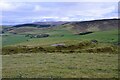
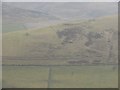
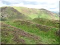
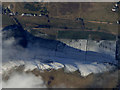
A circular hillfort located on the top of a rocky hill. The stone walls are partly damaged, probably due to stone robbing. The entrance is orientated to the SE.
Read More at ScotlandsPlaces.
You may be viewing yesterday's version of this page. To see the most up to date information please register for a free account.
Do not use the above information on other web sites or publications without permission of the contributor.
Nearby Images from Geograph Britain and Ireland:
©2020(licence)
©2010(licence)
©2013(licence)
©2018(licence)
©2018(licence)
The above images may not be of the site on this page, they are loaded from Geograph.
Please Submit an Image of this site or go out and take one for us!
Click here to see more info for this site
Nearby sites
Key: Red: member's photo, Blue: 3rd party photo, Yellow: other image, Green: no photo - please go there and take one, Grey: site destroyed
Download sites to:
KML (Google Earth)
GPX (GPS waypoints)
CSV (Garmin/Navman)
CSV (Excel)
To unlock full downloads you need to sign up as a Contributory Member. Otherwise downloads are limited to 50 sites.
Turn off the page maps and other distractions
Nearby sites listing. In the following links * = Image available
1.8km NE 44° Cleuch Hill* Cairn (NT07573546)
2.1km ESE 115° Knowe Kniffling* Hillfort (NT08163323)
2.3km ESE 104° Mill Rings Misc. Earthwork (NT08493357)
2.3km ENE 60° Parkgatestone Hill Ancient Village or Settlement (NT08293529)
3.4km SW 232° Nisbet* Hillfort (NT03543216)
4.1km WSW 248° Snaip Hill* Hillfort (NT02463269)
4.2km WSW 253° Culterpark Hill* Hillfort (NT02213305)
4.3km NNW 327° Moat Park Heritage Centre Museum (NT040378)
4.3km E 85° Whitslade Hill Burnt Mound Artificial Mound (NT10603447)
4.8km ENE 75° Helm End Hillfort (NT10983532)
5.2km E 95° Rachan Hill Henge (NT11423363)
5.2km WNW 296° Biggar Cursus Cursus (NT01663657)
5.2km E 91° Piper's Stone Standing Stone (Menhir) (NT11533400)
6.3km ENE 77° Dreva Craig* Standing Stone (Menhir) (NT12453545)
6.4km NNW 337° Carwood Farm Ancient Village or Settlement (NT039401)
6.5km ENE 78° Dreva Craig* Hillfort (NT12673533)
6.6km ESE 115° Woodend, Mossfennan Farm* Cist (NT12173124)
6.8km ENE 77° Dreva Hill West (Broughton)* Ancient Village or Settlement (NT12923553)
7.2km SE 131° Laigh Hill (Tweeddale)* Ancient Village or Settlement (NT11632933)
7.2km SE 136° Patervan Cairn, Buildings & Mound* Cairn (NT11192885)
7.4km SE 132° Norman's Castle* Stone Fort or Dun (NT11722915)
7.5km SE 137° Patervan Settlement* Ancient Village or Settlement (NT11252854)
7.7km E 79° Drumelzier Haugh* Standing Stone (Menhir) (NT13933542)
7.9km E 87° Tinnis Castle* Hillfort (NT14153444)
8.8km WNW 292° Boatbridge Quarry Cist (NS981376)
View more nearby sites and additional images


 We would like to know more about this location. Please feel free to add a brief description and any relevant information in your own language.
 Wir möchten mehr über diese Stätte erfahren. Bitte zögern Sie nicht, eine kurze Beschreibung und relevante Informationen in Deutsch hinzuzufügen.
 Nous aimerions en savoir encore un peu sur les lieux. S'il vous plaît n'hesitez pas à ajouter une courte description et tous les renseignements pertinents dans votre propre langue.
 Quisieramos informarnos un poco más de las lugares. No dude en añadir una breve descripción y otros datos relevantes en su propio idioma.