<< Text Pages >> Fallburn at Tinto - Hillfort in Scotland in South Lanarkshire
Submitted by Meglett on Sunday, 26 July 2015 Page Views: 4735
Iron Age and Later PrehistorySite Name: Fallburn at Tinto Alternative Name: Tinto Hillfort; Totherin HillCountry: Scotland County: South Lanarkshire Type: Hillfort
Nearest Town: Symington Nearest Village: Thankerton
Map Ref: NS96193674
Latitude: 55.613143N Longitude: 3.64965W
Condition:
| 5 | Perfect |
| 4 | Almost Perfect |
| 3 | Reasonable but with some damage |
| 2 | Ruined but still recognisable as an ancient site |
| 1 | Pretty much destroyed, possibly visible as crop marks |
| 0 | No data. |
| -1 | Completely destroyed |
| 5 | Superb |
| 4 | Good |
| 3 | Ordinary |
| 2 | Not Good |
| 1 | Awful |
| 0 | No data. |
| 5 | Can be driven to, probably with disabled access |
| 4 | Short walk on a footpath |
| 3 | Requiring a bit more of a walk |
| 2 | A long walk |
| 1 | In the middle of nowhere, a nightmare to find |
| 0 | No data. |
| 5 | co-ordinates taken by GPS or official recorded co-ordinates |
| 4 | co-ordinates scaled from a detailed map |
| 3 | co-ordinates scaled from a bad map |
| 2 | co-ordinates of the nearest village |
| 1 | co-ordinates of the nearest town |
| 0 | no data |
Internal Links:
External Links:
I have visited· I would like to visit
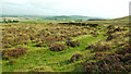
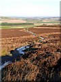
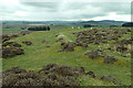
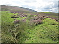
distantcamera visited on 19th Jan 2019 - their rating: Cond: 2 Amb: 3 Access: 4 I saw this on the OS map when I decided to walk Tinto Hill. You could easily walk past it as it looks like raised lumpy ground with heather on it. But if you walk into the middle of it you can see the scale and get a feeling for the layout.
Barely visible leaving car park and joining footpath to summit of hill. Short but uneven walk on gravel path (approx half a mile/ 0.76 kilometers).
When level with site it appears as raised lumps of heather. Closer inspection reveals the real size of this fort......nearly a hundred meters across, with three very visible furrows. To appreciate it fully means viewing from above, and that means a further walk uphill, and very worthwhile too. Update April 2017: Details on this site can be found on Canmore ID 47509, which has photographs, dimensions and a description of this hillfort.
Note: Have you visited this site? Do you have any photographs or further information you can add?
You may be viewing yesterday's version of this page. To see the most up to date information please register for a free account.
")
Do not use the above information on other web sites or publications without permission of the contributor.
Nearby Images from Geograph Britain and Ireland:
©2021(licence)
©2008(licence)
©2012(licence)
©2018(licence)
©2018(licence)
The above images may not be of the site on this page, they are loaded from Geograph.
Please Submit an Image of this site or go out and take one for us!
Click here to see more info for this site
Nearby sites
Key: Red: member's photo, Blue: 3rd party photo, Yellow: other image, Green: no photo - please go there and take one, Grey: site destroyed
Download sites to:
KML (Google Earth)
GPX (GPS waypoints)
CSV (Garmin/Navman)
CSV (Excel)
To unlock full downloads you need to sign up as a Contributory Member. Otherwise downloads are limited to 50 sites.
Turn off the page maps and other distractions
Nearby sites listing. In the following links * = Image available
2.1km ENE 64° Boatbridge Quarry Cist (NS981376)
5.5km E 90° Biggar Cursus Cursus (NT01663657)
7.0km ESE 120° Culterpark Hill* Hillfort (NT02213305)
7.4km ESE 122° Snaip Hill* Hillfort (NT02463269)
7.9km E 81° Moat Park Heritage Centre Museum (NT040378)
8.4km ENE 65° Carwood Farm Ancient Village or Settlement (NT039401)
8.5km S 184° Devonshaw Hill* Hillfort (NS954283)
8.6km ESE 121° Nisbet* Hillfort (NT03543216)
10.4km ESE 103° Mitchelhill Rings Hillfort (NT06283417)
11.1km NW 307° St Patrick's Well (Lanark) Holy Well or Sacred Spring (NS8744443652)
11.3km NE 36° Weston henge* Henge (NT03004578)
11.4km E 95° Cleuch Hill* Cairn (NT07573546)
11.7km NE 39° Tod Holes (Weston) Sculptured Stone (NT03844560)
11.9km S 190° Cold Chapel prehistoric settlement* Ancient Village or Settlement (NS93782512)
12.1km E 95° Parkgatestone Hill Ancient Village or Settlement (NT08293529)
12.4km ESE 105° Knowe Kniffling* Hillfort (NT08163323)
12.5km SW 218° Wildshaw Burn* Stone Circle (NS882271)
12.7km ESE 103° Mill Rings Misc. Earthwork (NT08493357)
13.1km S 187° Arbory Hill* Hillfort (NS944238)
13.7km ENE 57° Howburn Farm Ancient Village or Settlement (NT078440)
14.2km WNW 293° Clarkston (Dillarburn) Standing Stone (Menhir) (NS832426)
14.3km NNE 27° Burngrange Cairn (NT029494)
14.5km E 98° Whitslade Hill Burnt Mound Artificial Mound (NT10603447)
14.6km S 175° Normangill Henge* Henge (NS97252212)
14.7km SSW 202° Blackhill Hillfort (NS9032423216)
View more nearby sites and additional images


 We would like to know more about this location. Please feel free to add a brief description and any relevant information in your own language.
 Wir möchten mehr über diese Stätte erfahren. Bitte zögern Sie nicht, eine kurze Beschreibung und relevante Informationen in Deutsch hinzuzufügen.
 Nous aimerions en savoir encore un peu sur les lieux. S'il vous plaît n'hesitez pas à ajouter une courte description et tous les renseignements pertinents dans votre propre langue.
 Quisieramos informarnos un poco más de las lugares. No dude en añadir una breve descripción y otros datos relevantes en su propio idioma.