


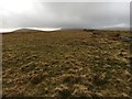
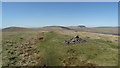
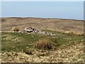
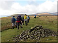
<< Our Photo Pages >> Craig Cwn Ddu cairns - Cairn in Wales in Powys
Submitted by cerrig on Tuesday, 02 May 2023 Page Views: 500
Neolithic and Bronze AgeSite Name: Craig Cwn Ddu cairnsCountry: Wales
NOTE: This site is 2.0 km away from the location you searched for.
County: Powys Type: Cairn
Nearest Town: Brecon Nearest Village: Hoel Senni
Map Ref: SN95452170
Latitude: 51.884025N Longitude: 3.520412W
Condition:
| 5 | Perfect |
| 4 | Almost Perfect |
| 3 | Reasonable but with some damage |
| 2 | Ruined but still recognisable as an ancient site |
| 1 | Pretty much destroyed, possibly visible as crop marks |
| 0 | No data. |
| -1 | Completely destroyed |
| 5 | Superb |
| 4 | Good |
| 3 | Ordinary |
| 2 | Not Good |
| 1 | Awful |
| 0 | No data. |
| 5 | Can be driven to, probably with disabled access |
| 4 | Short walk on a footpath |
| 3 | Requiring a bit more of a walk |
| 2 | A long walk |
| 1 | In the middle of nowhere, a nightmare to find |
| 0 | No data. |
| 5 | co-ordinates taken by GPS or official recorded co-ordinates |
| 4 | co-ordinates scaled from a detailed map |
| 3 | co-ordinates scaled from a bad map |
| 2 | co-ordinates of the nearest village |
| 1 | co-ordinates of the nearest town |
| 0 | no data |
Internal Links:
External Links:
")
You may be viewing yesterday's version of this page. To see the most up to date information please register for a free account.
")
")
")
Do not use the above information on other web sites or publications without permission of the contributor.
Nearby Images from Geograph Britain and Ireland:
©2018(licence)
©2018(licence)
©2020(licence)
©2016(licence)
©2012(licence)
The above images may not be of the site on this page, they are loaded from Geograph.
Please Submit an Image of this site or go out and take one for us!
Click here to see more info for this site
Nearby sites
Key: Red: member's photo, Blue: 3rd party photo, Yellow: other image, Green: no photo - please go there and take one, Grey: site destroyed
Download sites to:
KML (Google Earth)
GPX (GPS waypoints)
CSV (Garmin/Navman)
CSV (Excel)
To unlock full downloads you need to sign up as a Contributory Member. Otherwise downloads are limited to 50 sites.
Turn off the page maps and other distractions
Nearby sites listing. In the following links * = Image available
1.6km ENE 67° Rock art near Craig Cerrig Gleisiad* Rock Art (SN9697822316)
2.0km ENE 77° Blaenglyn* Cairn (SN974221)
3.9km NNE 11° Mynydd Illtud Standing Stone 2* Standing Stone (Menhir) (SN963255)
3.9km SW 224° Rhyd Uchaf cairn* Cairn (SN92641896)
3.9km SW 229° Maen Llia* Standing Stone (Menhir) (SN9241719186)
3.9km SW 228° Rhyd Uchaf Stone Alignment* Stone Row / Alignment (SN92451912)
4.0km SW 217° Fan Llia Round Cairn (2)* Cairn (SN92971855)
4.0km SSW 207° Fan Llia Summit Cairn* Cairn (SN9353218168)
4.0km SW 228° Llech Llia Recumbent Monolith* Natural Stone / Erratic / Other Natural Feature (SN92381908)
4.2km SW 228° Llech Llia multi banked henge* Henge (SN92321896)
4.2km N 1° Blaen Camlais Standing Stones* Standing Stones (SN9560525889)
4.3km SW 228° Maen Llia Barrow Round Barrow(s) (SN922189)
4.3km ESE 112° Pont-ar-daf Timber Circle (SN994200)
4.5km NNW 338° Tyle Bychan* Standing Stones (SN93872595)
4.5km SW 231° Fan Nedd Cairn* Cairn (SN9184618927)
5.0km SW 234° Fan Nedd stone pillar* Cairn (SN91341883)
5.1km W 277° Nant Cnewr-Fawr Stone* Standing Stone (Menhir) (SN9034122432)
5.2km W 279° Nant Cnewr-Fawr Cairn* Cairn (SN9030022608)
5.3km NNE 23° Mynydd Illtud Standing Stone 1* Standing Stone (Menhir) (SN97602651)
5.3km E 93° Corn Ddu Cairn* Cairn (SO00752133)
5.6km NW 324° Twyn y Gaer (Defynnog)* Hillfort (SN92252630)
5.6km NW 324° Twyn-y-Gaer (Heol Senni) Hillfort (SN922263)
5.7km S 171° Bedd Llywarch* Standing Stones (SN96251604)
5.7km E 90° Pen y Fan Cairn* Cairn (SO01202159)
6.4km S 181° Pen Fathor Uchaf* Cairn (SN95211528)
View more nearby sites and additional images


 We would like to know more about this location. Please feel free to add a brief description and any relevant information in your own language.
 Wir möchten mehr über diese Stätte erfahren. Bitte zögern Sie nicht, eine kurze Beschreibung und relevante Informationen in Deutsch hinzuzufügen.
 Nous aimerions en savoir encore un peu sur les lieux. S'il vous plaît n'hesitez pas à ajouter une courte description et tous les renseignements pertinents dans votre propre langue.
 Quisieramos informarnos un poco más de las lugares. No dude en añadir una breve descripción y otros datos relevantes en su propio idioma.