<< Our Photo Pages >> Fan Llia Summit Cairn - Cairn in Wales in Powys
Submitted by cerrig on Tuesday, 05 January 2010 Page Views: 4500
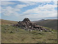
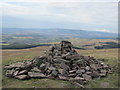
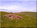
Neolithic and Bronze AgeSite Name: Fan Llia Summit CairnCountry: Wales
NOTE: This site is 0.3 km away from the location you searched for.
County: Powys Type: Cairn
Nearest Town: Sennybridge Nearest Village: Ystradfellte
Map Ref: SN9353218168
Latitude: 51.851917N Longitude: 3.547178W
Condition:
| 5 | Perfect |
| 4 | Almost Perfect |
| 3 | Reasonable but with some damage |
| 2 | Ruined but still recognisable as an ancient site |
| 1 | Pretty much destroyed, possibly visible as crop marks |
| 0 | No data. |
| -1 | Completely destroyed |
| 5 | Superb |
| 4 | Good |
| 3 | Ordinary |
| 2 | Not Good |
| 1 | Awful |
| 0 | No data. |
| 5 | Can be driven to, probably with disabled access |
| 4 | Short walk on a footpath |
| 3 | Requiring a bit more of a walk |
| 2 | A long walk |
| 1 | In the middle of nowhere, a nightmare to find |
| 0 | No data. |
| 5 | co-ordinates taken by GPS or official recorded co-ordinates |
| 4 | co-ordinates scaled from a detailed map |
| 3 | co-ordinates scaled from a bad map |
| 2 | co-ordinates of the nearest village |
| 1 | co-ordinates of the nearest town |
| 0 | no data |
Internal Links:
External Links:
")
It is on a National long distance pathway,the Beacons Way, so it is readily accessible,but a bit of a walk to get to the top. There is a good car park in the valley below at Blaen Llia that connects with the footpath.
This is a fine weather site as it is over 600 meters high.
You may be viewing yesterday's version of this page. To see the most up to date information please register for a free account.
")
")
")
")
Do not use the above information on other web sites or publications without permission of the contributor.
Nearby Images from Geograph Britain and Ireland:

©2023(licence)
©2013(licence)
©2013(licence)
©2014(licence)

©2015(licence)
The above images may not be of the site on this page, they are loaded from Geograph.
Please Submit an Image of this site or go out and take one for us!
Click here to see more info for this site
Nearby sites
Key: Red: member's photo, Blue: 3rd party photo, Yellow: other image, Green: no photo - please go there and take one, Grey: site destroyed
Download sites to:
KML (Google Earth)
GPX (GPS waypoints)
CSV (Garmin/Navman)
CSV (Excel)
To unlock full downloads you need to sign up as a Contributory Member. Otherwise downloads are limited to 50 sites.
Turn off the page maps and other distractions
Nearby sites listing. In the following links * = Image available
678m WNW 303° Fan Llia Round Cairn (2)* Cairn (SN92971855)
1.2km NW 310° Rhyd Uchaf cairn* Cairn (SN92641896)
1.4km NW 310° Rhyd Uchaf Stone Alignment* Stone Row / Alignment (SN92451912)
1.4km WNW 302° Llech Llia multi banked henge* Henge (SN92321896)
1.5km NW 307° Llech Llia Recumbent Monolith* Natural Stone / Erratic / Other Natural Feature (SN92381908)
1.5km NW 311° Maen Llia* Standing Stone (Menhir) (SN9241719186)
1.5km WNW 298° Maen Llia Barrow Round Barrow(s) (SN922189)
1.8km WNW 293° Fan Nedd Cairn* Cairn (SN9184618927)
2.3km WNW 286° Fan Nedd stone pillar* Cairn (SN91341883)
2.9km SW 214° Maen Madoc* Standing Stone (Menhir) (SN91821577)
3.3km SSE 149° Pen Fathor Uchaf* Cairn (SN95211528)
3.4km SE 127° Bedd Llywarch* Standing Stones (SN96251604)
4.0km NNE 27° Craig Cwn Ddu cairns* Cairn (SN95452170)
4.5km SW 218° Blaen-Nedd Isaf Ring Cairn (SN907147)
4.5km SSW 202° Gelli-Nedd* Hillfort (SN91741400)
5.3km NW 322° Nant Cnewr-Fawr Stone* Standing Stone (Menhir) (SN9034122432)
5.4km NE 38° Rock art near Craig Cerrig Gleisiad* Rock Art (SN9697822316)
5.5km NW 323° Nant Cnewr-Fawr Cairn* Cairn (SN9030022608)
5.5km NE 43° Blaenglyn* Cairn (SN974221)
5.6km S 175° Carn yr Arian* Round Cairn (SN93901253)
5.9km SSW 201° Dyffryn Nedd Hillfort (SN913127)
5.9km SSE 151° Blaen Hepste* Henge (SN9633012960)
6.1km W 259° Pwll Byfre Hut Circle 1 Ancient Village or Settlement (SN87501711)
6.1km SE 140° Cefn Esgair Ring Cairn (SN974134)
6.1km ENE 71° Pont-ar-daf Timber Circle (SN994200)
View more nearby sites and additional images


 We would like to know more about this location. Please feel free to add a brief description and any relevant information in your own language.
 Wir möchten mehr über diese Stätte erfahren. Bitte zögern Sie nicht, eine kurze Beschreibung und relevante Informationen in Deutsch hinzuzufügen.
 Nous aimerions en savoir encore un peu sur les lieux. S'il vous plaît n'hesitez pas à ajouter une courte description et tous les renseignements pertinents dans votre propre langue.
 Quisieramos informarnos un poco más de las lugares. No dude en añadir una breve descripción y otros datos relevantes en su propio idioma.