 with our Megalithic Portal iPhone app")

<< Our Photo Pages >> Auldearn Stone Row - Stone Row / Alignment in Scotland in Highlands
Submitted by Anne T on Friday, 06 May 2016 Page Views: 2928
Neolithic and Bronze AgeSite Name: Auldearn Stone Row Alternative Name: KinstearyCountry: Scotland County: Highlands Type: Stone Row / Alignment
Nearest Town: Nairn Nearest Village: Auldearn
Map Ref: NH93125486
Latitude: 57.571121N Longitude: 3.788593W
Condition:
| 5 | Perfect |
| 4 | Almost Perfect |
| 3 | Reasonable but with some damage |
| 2 | Ruined but still recognisable as an ancient site |
| 1 | Pretty much destroyed, possibly visible as crop marks |
| 0 | No data. |
| -1 | Completely destroyed |
| 5 | Superb |
| 4 | Good |
| 3 | Ordinary |
| 2 | Not Good |
| 1 | Awful |
| 0 | No data. |
| 5 | Can be driven to, probably with disabled access |
| 4 | Short walk on a footpath |
| 3 | Requiring a bit more of a walk |
| 2 | A long walk |
| 1 | In the middle of nowhere, a nightmare to find |
| 0 | No data. |
| 5 | co-ordinates taken by GPS or official recorded co-ordinates |
| 4 | co-ordinates scaled from a detailed map |
| 3 | co-ordinates scaled from a bad map |
| 2 | co-ordinates of the nearest village |
| 1 | co-ordinates of the nearest town |
| 0 | no data |
Internal Links:
External Links:
I have visited· I would like to visit
Klingon visited on 10th Feb 2019 - their rating: Cond: 2 Amb: 2 Access: 4
SandyG visited on 9th Jul 2018 - their rating: Cond: 2 Amb: 3 Access: 5 This row stands mainly in a private garden and permission to visit it should be sought at Stonerow House. Car parking is available nearby at NH 93300 54800. It is a short walk from here to the row.
Average ratings for this site from all visit loggers: Condition: 2 Ambience: 2.5 Access: 4.5
")
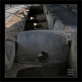
Auldearn Stone Row, also known as Kinsteary, is recorded in Canmore ID 15597 as a "Cairn and Stone Row". The row has a length of 76.2 metres and is at an orientation of 135 degrees. The site sits at an altitude of 37 metres above sea level and looks over the sea to the north and west.
The Canmore record describes a cairn with a stone row extending from it in a south-easterly direction. The cairn is described as having a ditch and vallum; it was excavated in 1903 and found to contain a cist.
The alignment consists of six large boulders some 7 feet high and 27 feet apart. One boulder appears to be missing. The Canmore record goes onto say that of the six stones, only 2 remain upright.
Directions on how to get to this site are given on the Modern Antiquarian site page for Auldearn: "Coming from the east of Auldearn, on the A96, take the B9101 towards the village then take the first minor road heading south east. The cairn and stone row are in the field immediately after Roundall Wood. Look west." (correct as of February 2009).
Update September 2019: The Stone Rows of Great Britain feature an entry for this stone row - see their page for Auldearn, which includes photographs of the alignment and of the individual stones, a description, a simplified plan of the row with its associated cairn, plus access information. SRoGB says that originally the row would have had restricted views of the sea as you moved up and down it.
Note: The Stone Rows of Great Britain notes: "This row stands mainly in a private garden and permission to visit it should be sought at Stonerow House".
You may be viewing yesterday's version of this page. To see the most up to date information please register for a free account.
")
")
")
")
")
")
")
")
")
")
")
Do not use the above information on other web sites or publications without permission of the contributor.
Click here to see more info for this site
Nearby sites
Key: Red: member's photo, Blue: 3rd party photo, Yellow: other image, Green: no photo - please go there and take one, Grey: site destroyed
Download sites to:
KML (Google Earth)
GPX (GPS waypoints)
CSV (Garmin/Navman)
CSV (Excel)
To unlock full downloads you need to sign up as a Contributory Member. Otherwise downloads are limited to 50 sites.
![]()
Turn off the page maps and other distractions
Nearby sites listing. In the following links * = Image available
790m WNW 303° Auldearn Stone Circle* Stone Circle (NH9246755309)
2.5km ESE 118° Moyness* Stone Circle (NH95275364)
3.0km E 88° Golford Ring Cairn* Ring Cairn (NH96165488)
3.4km NE 54° Macbeth's Hillock Natural Stone / Erratic / Other Natural Feature (NH95905675)
4.3km ESE 112° Hanover Cairn (NH971531)
5.1km S 178° Achnatone* Stone Circle (NH932498)
6.0km ENE 61° Brodie* Class II Pictish Symbol Stone (NH98425766)
8.4km WSW 240° Cawdor* Standing Stone (Menhir) (NH857508)
8.8km E 85° Loch of Blairs Cairn (NJ019554)
9.0km SW 224° Little Urchany* Clava Cairn (NH8665648566)
10.5km W 272° Kebbuck Stone* Class I / Class II Hybrid Pictish Symbol Stone (NH826555)
10.7km WSW 258° Loch of the Clans Crannog* Crannog (NH82575297)
10.8km E 86° Altyre House Ogham Stone* Sculptured Stone (NJ03915537)
12.2km S 176° Glenferness* Class II Pictish Symbol Stone (NH93664261)
12.4km ENE 66° Sueno's Stone* Class III Pictish Cross Slab (NJ0465559533)
13.2km SE 130° Chapel Hill (Moray) Stone Circle (NJ030460)
13.6km SE 125° Little Coshellach Round Cairn (NJ040467)
13.8km E 80° Templestone* Stone Circle (NJ0683656941)
14.9km E 81° Califer Round Cairn (NJ079568)
16.0km WSW 240° Dalgrambich Farm* Standing Stones (NH79104715)
16.5km WSW 245° Dalcross Mains* Stone Circle (NH779484)
17.5km NW 314° Fiddler's Well Holy Well or Sacred Spring (NH807673)
17.6km NW 313° St Mary's Well (Cromarty)* Holy Well or Sacred Spring (NH805672)
17.7km SSE 152° Dava Station Round Cairn (NJ010390)
17.8km SE 138° Lynagowan Stone Circle (NJ048414)
View more nearby sites and additional images


 We would like to know more about this location. Please feel free to add a brief description and any relevant information in your own language.
 Wir möchten mehr über diese Stätte erfahren. Bitte zögern Sie nicht, eine kurze Beschreibung und relevante Informationen in Deutsch hinzuzufügen.
 Nous aimerions en savoir encore un peu sur les lieux. S'il vous plaît n'hesitez pas à ajouter une courte description et tous les renseignements pertinents dans votre propre langue.
 Quisieramos informarnos un poco más de las lugares. No dude en añadir una breve descripción y otros datos relevantes en su propio idioma.