<< Our Photo Pages >> Sgwd Gwladus Stone - Natural Stone / Erratic / Other Natural Feature in Wales in Powys
Submitted by pab on Monday, 12 March 2007 Page Views: 7237
Natural PlacesSite Name: Sgwd Gwladus StoneCountry: Wales
NOTE: This site is 3.9 km away from the location you searched for.
County: Powys Type: Natural Stone / Erratic / Other Natural Feature
Map Ref: SN896095
Latitude: 51.773249N Longitude: 3.601477W
Condition:
| 5 | Perfect |
| 4 | Almost Perfect |
| 3 | Reasonable but with some damage |
| 2 | Ruined but still recognisable as an ancient site |
| 1 | Pretty much destroyed, possibly visible as crop marks |
| 0 | No data. |
| -1 | Completely destroyed |
| 5 | Superb |
| 4 | Good |
| 3 | Ordinary |
| 2 | Not Good |
| 1 | Awful |
| 0 | No data. |
| 5 | Can be driven to, probably with disabled access |
| 4 | Short walk on a footpath |
| 3 | Requiring a bit more of a walk |
| 2 | A long walk |
| 1 | In the middle of nowhere, a nightmare to find |
| 0 | No data. |
| 5 | co-ordinates taken by GPS or official recorded co-ordinates |
| 4 | co-ordinates scaled from a detailed map |
| 3 | co-ordinates scaled from a bad map |
| 2 | co-ordinates of the nearest village |
| 1 | co-ordinates of the nearest town |
| 0 | no data |
Internal Links:
External Links:
I have visited· I would like to visit
PAB has visited here
")
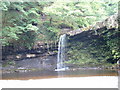
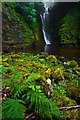
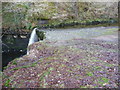
Wonderfully proportioned erratic above the Sgwd Gwladus falls located in the 'Waterfall country' between Ystradfellte and Pontneddfechan.
As can be seen by the comparison with the 'marker' in the accompanying picture, the erratic is approximately 2 metres cubed.
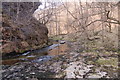
It is next to the Afon (River) Pyrddin which forms the boundary between the counties of Powys and Neath Port Talbot (formerly West Glamorgan) at this point.
You may be viewing yesterday's version of this page. To see the most up to date information please register for a free account.
")
Do not use the above information on other web sites or publications without permission of the contributor.
Nearby Images from Geograph Britain and Ireland:
©2005(licence)
©2010(licence)
©2007(licence)
©2023(licence)
©2012(licence)
The above images may not be of the site on this page, they are loaded from Geograph.
Please Submit an Image of this site or go out and take one for us!
Click here to see more info for this site
Nearby sites
Key: Red: member's photo, Blue: 3rd party photo, Yellow: other image, Green: no photo - please go there and take one, Grey: site destroyed
Download sites to:
KML (Google Earth)
GPX (GPS waypoints)
CSV (Garmin/Navman)
CSV (Excel)
To unlock full downloads you need to sign up as a Contributory Member. Otherwise downloads are limited to 50 sites.
Turn off the page maps and other distractions
Nearby sites listing. In the following links * = Image available
2.4km NNW 342° Nant Hir stone* Marker Stone (SN889118)
3.6km NNE 27° Dyffryn Nedd Hillfort (SN913127)
5.0km NNE 24° Gelli-Nedd* Hillfort (SN91741400)
5.2km NE 54° Carn yr Arian* Round Cairn (SN93901253)
5.3km N 11° Blaen-Nedd Isaf Ring Cairn (SN907147)
5.5km NW 323° Pump Maen (Five Stones)* Stone Row / Alignment (SN86361400)
5.6km S 176° Y Foel Cherwn Cairn (SN89840388)
5.8km S 179° Craig-Y-Pant Cairn (SN89560367)
6.1km NW 325° Saith Maen SE* Stone Row / Alignment (SN862146)
6.1km NNW 327° The Gnomen Standing Stone (Menhir) (SN8635214716)
6.2km NNW 328° Saith Maen East Cairn* Cairn (SN8642414831)
6.3km W 260° Cwm Irfon Standing Stones (Seven Sisters) Standing Stones (SN834085)
6.3km SSE 168° Garn Fach Cairn (SN90740327)
6.4km SSE 159° Llyn Fawr* Holy Well or Sacred Spring (SN91770347)
6.5km NNW 341° Carreg Cadno* Stone Row / Alignment (SN87671569)
6.6km NNW 329° Careg Lywd 2* Stone Row / Alignment (SN8629315186)
6.6km NNE 18° Maen Madoc* Standing Stone (Menhir) (SN91821577)
6.7km SSE 169° Carn Foesan Cairn (SN90780288)
6.9km NNW 328° Penwyllt Cairn* Cairn (SN8606715391)
7.2km NNW 341° The Nipple* Cairn (SN87441635)
7.4km NW 321° Powell's Cave Cave or Rock Shelter (SN84991535)
7.5km ENE 61° Blaen Hepste* Henge (SN9633012960)
7.7km E 94° Mynydd y Glog* Cairn (SN97270886)
7.9km NNW 343° Pwll Byfre Hut Circle 1 Ancient Village or Settlement (SN87501711)
7.9km NNW 343° Pwll Byfre Hut Circle 2 Ancient Village or Settlement (SN87471711)
View more nearby sites and additional images


 We would like to know more about this location. Please feel free to add a brief description and any relevant information in your own language.
 Wir möchten mehr über diese Stätte erfahren. Bitte zögern Sie nicht, eine kurze Beschreibung und relevante Informationen in Deutsch hinzuzufügen.
 Nous aimerions en savoir encore un peu sur les lieux. S'il vous plaît n'hesitez pas à ajouter une courte description et tous les renseignements pertinents dans votre propre langue.
 Quisieramos informarnos un poco más de las lugares. No dude en añadir una breve descripción y otros datos relevantes en su propio idioma.