<< Our Photo Pages >> Gelli-Nedd - Hillfort in Wales in Powys
Submitted by h_fenton on Sunday, 31 August 2014 Page Views: 5235
Iron Age and Later PrehistorySite Name: Gelli-NeddCountry: Wales
NOTE: This site is 0.5 km away from the location you searched for.
County: Powys Type: Hillfort
Nearest Village: Ystradfellte
Map Ref: SN91741400
Latitude: 51.814112N Longitude: 3.571879W
Condition:
| 5 | Perfect |
| 4 | Almost Perfect |
| 3 | Reasonable but with some damage |
| 2 | Ruined but still recognisable as an ancient site |
| 1 | Pretty much destroyed, possibly visible as crop marks |
| 0 | No data. |
| -1 | Completely destroyed |
| 5 | Superb |
| 4 | Good |
| 3 | Ordinary |
| 2 | Not Good |
| 1 | Awful |
| 0 | No data. |
| 5 | Can be driven to, probably with disabled access |
| 4 | Short walk on a footpath |
| 3 | Requiring a bit more of a walk |
| 2 | A long walk |
| 1 | In the middle of nowhere, a nightmare to find |
| 0 | No data. |
| 5 | co-ordinates taken by GPS or official recorded co-ordinates |
| 4 | co-ordinates scaled from a detailed map |
| 3 | co-ordinates scaled from a bad map |
| 2 | co-ordinates of the nearest village |
| 1 | co-ordinates of the nearest town |
| 0 | no data |
Internal Links:
External Links:
I have visited· I would like to visit
DrewParsons would like to visit
")
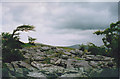
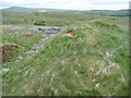
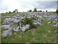
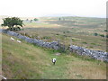
The ditch and rampart continue around the east side but are only slight here, as the main protection is afforded by the slope of the hill. Around the south side the rampart and ditch continue until they reach an extant area of limestone pavement where it is less easy to follow the course - possibly just the slight remains of a wall here. On the West there is no ditch or rampart and the site is protected by a small cliff and a rock scree slope. at the centre of the fort is a small irregular shaped mound with slight traces of a ditch around it measuring 8-10m across.
The ridge which Gelli Nedd hillfort sits on has been extensively worked for limestone although these quarries seem to have had little impact upon the hillfort itself.
More at : Coflein
You may be viewing yesterday's version of this page. To see the most up to date information please register for a free account.
Do not use the above information on other web sites or publications without permission of the contributor.
Nearby Images from Geograph Britain and Ireland:
©2014(licence)
©2011(licence)
©2011(licence)
©2015(licence)
©2005(licence)
The above images may not be of the site on this page, they are loaded from Geograph.
Please Submit an Image of this site or go out and take one for us!
Click here to see more info for this site
Nearby sites
Key: Red: member's photo, Blue: 3rd party photo, Yellow: other image, Green: no photo - please go there and take one, Grey: site destroyed
Download sites to:
KML (Google Earth)
GPX (GPS waypoints)
CSV (Garmin/Navman)
CSV (Excel)
To unlock full downloads you need to sign up as a Contributory Member. Otherwise downloads are limited to 50 sites.
Turn off the page maps and other distractions
Nearby sites listing. In the following links * = Image available
1.3km WNW 303° Blaen-Nedd Isaf Ring Cairn (SN907147)
1.4km SSW 197° Dyffryn Nedd Hillfort (SN913127)
1.8km N 1° Maen Madoc* Standing Stone (Menhir) (SN91821577)
2.6km ESE 123° Carn yr Arian* Round Cairn (SN93901253)
3.6km SW 231° Nant Hir stone* Marker Stone (SN889118)
3.7km ENE 68° Pen Fathor Uchaf* Cairn (SN95211528)
4.4km WNW 291° Carreg Cadno* Stone Row / Alignment (SN87671569)
4.5km NNE 22° Fan Llia Summit Cairn* Cairn (SN9353218168)
4.7km ESE 102° Blaen Hepste* Henge (SN9633012960)
4.7km NNE 14° Fan Llia Round Cairn (2)* Cairn (SN92971855)
4.8km N 354° Fan Nedd stone pillar* Cairn (SN91341883)
4.9km WNW 297° The Nipple* Cairn (SN87441635)
4.9km N 4° Maen Llia Barrow Round Barrow(s) (SN922189)
4.9km N 360° Fan Nedd Cairn* Cairn (SN9184618927)
4.9km ENE 64° Bedd Llywarch* Standing Stones (SN96251604)
5.0km SSW 204° Sgwd Gwladus Stone* Natural Stone / Erratic / Other Natural Feature (SN896095)
5.0km N 5° Llech Llia multi banked henge* Henge (SN92321896)
5.0km N 9° Rhyd Uchaf cairn* Cairn (SN92641896)
5.1km N 6° Llech Llia Recumbent Monolith* Natural Stone / Erratic / Other Natural Feature (SN92381908)
5.2km N 7° Rhyd Uchaf Stone Alignment* Stone Row / Alignment (SN92451912)
5.2km N 6° Maen Llia* Standing Stone (Menhir) (SN9241719186)
5.2km NW 305° Pwll Byfre Hut Circle 1 Ancient Village or Settlement (SN87501711)
5.3km NW 305° Pwll Byfre Hut Circle 2 Ancient Village or Settlement (SN87471711)
5.4km W 269° Pump Maen (Five Stones)* Stone Row / Alignment (SN86361400)
5.4km W 278° Saith Maen East Cairn* Cairn (SN8642414831)
View more nearby sites and additional images


 We would like to know more about this location. Please feel free to add a brief description and any relevant information in your own language.
 Wir möchten mehr über diese Stätte erfahren. Bitte zögern Sie nicht, eine kurze Beschreibung und relevante Informationen in Deutsch hinzuzufügen.
 Nous aimerions en savoir encore un peu sur les lieux. S'il vous plaît n'hesitez pas à ajouter une courte description et tous les renseignements pertinents dans votre propre langue.
 Quisieramos informarnos un poco más de las lugares. No dude en añadir una breve descripción y otros datos relevantes en su propio idioma.