


<< Our Photo Pages >> Mercat Cross (Clackmannan) - Ancient Cross in Scotland in Clackmannanshire
Submitted by Anne T on Monday, 04 December 2017 Page Views: 2325
Early MedievalSite Name: Mercat Cross (Clackmannan) Alternative Name: Burgh Cross (Clackmannan); Clackmannan Cross; Market Cross (Clackmannan)Country: Scotland County: Clackmannanshire Type: Ancient Cross
Nearest Town: Clackmannan
Map Ref: NS9111091889
Latitude: 56.107310N Longitude: 3.752422W
Condition:
| 5 | Perfect |
| 4 | Almost Perfect |
| 3 | Reasonable but with some damage |
| 2 | Ruined but still recognisable as an ancient site |
| 1 | Pretty much destroyed, possibly visible as crop marks |
| 0 | No data. |
| -1 | Completely destroyed |
| 5 | Superb |
| 4 | Good |
| 3 | Ordinary |
| 2 | Not Good |
| 1 | Awful |
| 0 | No data. |
| 5 | Can be driven to, probably with disabled access |
| 4 | Short walk on a footpath |
| 3 | Requiring a bit more of a walk |
| 2 | A long walk |
| 1 | In the middle of nowhere, a nightmare to find |
| 0 | No data. |
| 5 | co-ordinates taken by GPS or official recorded co-ordinates |
| 4 | co-ordinates scaled from a detailed map |
| 3 | co-ordinates scaled from a bad map |
| 2 | co-ordinates of the nearest village |
| 1 | co-ordinates of the nearest town |
| 0 | no data |
Be the first person to rate this site - see the 'Contribute!' box in the right hand menu.
Internal Links:
External Links:
I have visited· I would like to visit
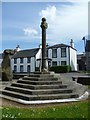
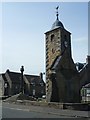
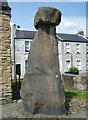
Anne T visited on 14th Jul 2018 - their rating: Cond: 3 Amb: 4 Access: 5 The Mercat Cross, Clackmannan: The Mercat Cross, the Stone of Mannan and the Tolbooth are all in the same small area. When we arrived, it was about 6.40pm and the sun was low in the sky, giving deep shadows. Much to the amusement of the people drinking outside the pub behind the Tolbooth, I took a number of photographs of these monuments, then retreated to the car to try and get out of the heat. Was worth seeing, but at this time of day I wanted something to eat, drink and cool shade!
 (PID:169787)")
The Northern Antiquariann (TNA) features a page for this probably 16th century cross - see their entry for Mercat Cross, Clackmannan, Clackmannanshire, which gives directions for finding the cross together with an image of the 1866 OS map showing the location of the cross, photographs, an 1899 drawing and a brief archaeology & history.
For more information see Canmore ID 48318, an extract of which reads: "stands in the main street beside the Tolbooth. Although the stepped base has been renewed, the shaft is original. It is 9'6" in height, and is octagonal in section, measuring 11" in diameter. The capital is moulded and bears the Bruce arms. (1933, visited 1928). According to Dr Gordon (T C Gordon, The Manse, Clackmannan) the cross is correctly positioned as being on its original site. The Bruce arms on the head of the cross are still to be seen, but the steps are of recent origin (1950)." A more recent entry tells us that works were carried out on the cross in 2006 and 2007.
You may be viewing yesterday's version of this page. To see the most up to date information please register for a free account.
 (PID:184170)")
 (PID:184169)")
 (PID:184168)")
 (PID:184167)")
Do not use the above information on other web sites or publications without permission of the contributor.
Nearby Images from Geograph Britain and Ireland:
©2013(licence)
©2013(licence)
©2013(licence)

©2025(licence)

©2025(licence)
The above images may not be of the site on this page, they are loaded from Geograph.
Please Submit an Image of this site or go out and take one for us!
Click here to see more info for this site
Nearby sites
Key: Red: member's photo, Blue: 3rd party photo, Yellow: other image, Green: no photo - please go there and take one, Grey: site destroyed
Download sites to:
KML (Google Earth)
GPX (GPS waypoints)
CSV (Garmin/Navman)
CSV (Excel)
To unlock full downloads you need to sign up as a Contributory Member. Otherwise downloads are limited to 50 sites.
Turn off the page maps and other distractions
Nearby sites listing. In the following links * = Image available
9m S 178° Stone of Mannan* Standing Stone (Menhir) (NS91119188)
229m S 176° Lady Well (Clackmannan) Holy Well or Sacred Spring (NS91129166)
873m NW 323° Hawk Hill (Alloa) Stone Circle (NS906926)
894m E 81° Hawk Hill Stone Circle (NS920920)
1.2km NW 307° Parkmill Cross (Alloa) Ancient Cross (NS9013392661)
2.0km NE 41° Grassmainston Well (Clackmannan) Holy Well or Sacred Spring (NS9247893403)
2.2km WNW 294° Hawk Hill Cairn (Alloa) Cairn (NS89119282)
3.8km SE 127° Tulliallan Castle Sculptured Stone (NS94058952)
4.4km SE 146° Greenfield Park, Alloa Stone Row / Alignment (NS935882)
4.7km NNE 33° Balhearty Standing Stone (Menhir) (NS9378295816)
4.8km SSE 154° Market Cross (Kincardine)* Ancient Cross (NS9312087515)
5.4km NNE 14° Cunninghar* Stone Circle (NS9256097080)
5.6km N 359° Lady's Well (Tillicoultry) Holy Well or Sacred Spring (NS91119749)
5.7km SE 139° Gubber Hill Standing Stone (Menhir) (NS948875)
5.8km NNE 11° Tillicoultry House Carving (Tillicoultry) Rock Art (NS92409752)
5.8km NNW 335° St Serf's Well (Alva) Holy Well or Sacred Spring (NS88819723)
6.1km WNW 303° Priest's Well (Tullibody) Holy Well or Sacred Spring (NS8606995324)
6.1km WNW 303° The Maiden Stone (Tullibody)* Sculptured Stone (NS86039533)
6.1km WNW 296° Haer Stane* Standing Stone (Menhir) (NS85659475)
6.2km NNW 334° Dwarf's Tomb (Alva) Burial Chamber or Dolmen (NS88489754)
6.3km SW 235° Castleton 1* Rock Art (NS85878840)
6.3km ESE 107° Castle Hill (Culross) Hillfort (NS97118992)
6.4km SW 234° Castleton 2* Rock Art (NS85818831)
6.5km NNW 336° Ladies Well (Alva) Holy Well or Sacred Spring (NS88579788)
6.5km WNW 302° Lady's Well (Tullibody) Holy Well or Sacred Spring (NS85639548)
View more nearby sites and additional images


 We would like to know more about this location. Please feel free to add a brief description and any relevant information in your own language.
 Wir möchten mehr über diese Stätte erfahren. Bitte zögern Sie nicht, eine kurze Beschreibung und relevante Informationen in Deutsch hinzuzufügen.
 Nous aimerions en savoir encore un peu sur les lieux. S'il vous plaît n'hesitez pas à ajouter une courte description et tous les renseignements pertinents dans votre propre langue.
 Quisieramos informarnos un poco más de las lugares. No dude en añadir una breve descripción y otros datos relevantes en su propio idioma.