<< Our Photo Pages >> Mynydd Clywedog - Stone Row / Alignment in Wales in Gwynedd
Submitted by Anne T on Friday, 06 May 2016 Page Views: 4228
Neolithic and Bronze AgeSite Name: Mynydd ClywedogCountry: Wales County: Gwynedd Type: Stone Row / Alignment
Nearest Town: Machynlleth Nearest Village: Nant-y-dugoed
Map Ref: SH9082914260
Latitude: 52.714948N Longitude: 3.617562W
Condition:
| 5 | Perfect |
| 4 | Almost Perfect |
| 3 | Reasonable but with some damage |
| 2 | Ruined but still recognisable as an ancient site |
| 1 | Pretty much destroyed, possibly visible as crop marks |
| 0 | No data. |
| -1 | Completely destroyed |
| 5 | Superb |
| 4 | Good |
| 3 | Ordinary |
| 2 | Not Good |
| 1 | Awful |
| 0 | No data. |
| 5 | Can be driven to, probably with disabled access |
| 4 | Short walk on a footpath |
| 3 | Requiring a bit more of a walk |
| 2 | A long walk |
| 1 | In the middle of nowhere, a nightmare to find |
| 0 | No data. |
| 5 | co-ordinates taken by GPS or official recorded co-ordinates |
| 4 | co-ordinates scaled from a detailed map |
| 3 | co-ordinates scaled from a bad map |
| 2 | co-ordinates of the nearest village |
| 1 | co-ordinates of the nearest town |
| 0 | no data |
Internal Links:
External Links:
I have visited· I would like to visit
SandyG visited on 30th Aug 2018 - their rating: Cond: 4 Amb: 5 Access: 1 Limited road side car parking is available at SH 91262 13047. From here it is possible to carefully cross the busy A458 and follow the farm road to Braich-llwyd and then the track to access land at SH 90203 13770. From here follow the track northward to the row. Alternatively permission to use the track leading north from Braich-llwyd could be sought at the farm or nearby Talglanau.
")
Information for this alignment comes from the Stone Rows of Great Britain website - see their entry for Mynydd Clywedog. SRoGB tells us this single stone row 123.6m long and is made up of at least 10 standing stones. It is "situated at the western foot of a pronounced ridge. The row is orientated north to south and protrudes from deep peat which means that the stones will be much bigger and others may be completely hidden".
The SRoGB entry includes a description, plans of the row (from a survey carried out in August 2019, photographs of the alignment and the individual stones, access information and a list of online resources for more information.
SandyG also explores and illustrates the sea views and landscape features visible from the row, adding: "The row has a sea view reveal, a possible astronomical link and stands in the vicinity of cairns … This stone row was found in the 1980’s by the farmer Tegwyn Jones". The row is also recorded as Coflein NPRN 508330 (Stone Row, Mynydd Clywedog), who surveyed the site in 2009.
Note: Visitors please be careful to follow the access information on the Stone Rows of Great Britain entry - click on the link above. Thank you.
You may be viewing yesterday's version of this page. To see the most up to date information please register for a free account.
")
")
")
")
Do not use the above information on other web sites or publications without permission of the contributor.
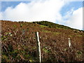
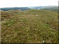
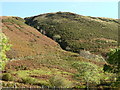
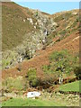
Nearby Images from Geograph Britain and Ireland:
©2007(licence)
©2020(licence)
©2007(licence)
©2007(licence)
©2007(licence)
The above images may not be of the site on this page, they are loaded from Geograph.
Please Submit an Image of this site or go out and take one for us!
Click here to see more info for this site
Nearby sites
Key: Red: member's photo, Blue: 3rd party photo, Yellow: other image, Green: no photo - please go there and take one, Grey: site destroyed
Download sites to:
KML (Google Earth)
GPX (GPS waypoints)
CSV (Garmin/Navman)
CSV (Excel)
To unlock full downloads you need to sign up as a Contributory Member. Otherwise downloads are limited to 50 sites.
![]()
Turn off the page maps and other distractions
Nearby sites listing. In the following links * = Image available
590m SE 140° Ffridd Braich Llwyd Ring Cairn* Ring Cairn (SH912138)
671m SE 145° Ffridd Braich-Llwyd* Stone Row / Alignment (SH912137)
798m SE 133° Ffridd Braich Llwyd Round Cairn* Round Cairn (SH914137)
3.2km SW 222° Collfryn mound* Artificial Mound (SH8864511916)
6.0km WSW 241° Camlan* Modern Stone Circle etc (SH855115)
6.4km ENE 72° The Tryfel Stones* Stone Row / Alignment (SH96991609)
7.8km ENE 78° Mynydd Dyfnant* Stone Row / Alignment (SH9852015742)
8.0km ESE 107° St Tydecho's Well Holy Well or Sacred Spring (SH985118)
10.8km ESE 110° St Cadfan's Well* Holy Well or Sacred Spring (SJ010104)
11.4km WNW 290° Marchnad Mawr Settlement* Ancient Village or Settlement (SH802184)
11.4km WNW 291° Marchnad Mawr Ring Cairn* Ring Cairn (SH802185)
11.5km WNW 291° Cairn North of Nant Helygog* Cairn (SH802186)
11.5km WNW 290° Marchnad Mawr Round Cairn* Round Cairn (SH801185)
12.4km NW 317° Dolddeuli* Standing Stone (Menhir) (SH826236)
13.1km ENE 63° Round Cairn South of Groes y Forwm* Round Cairn (SJ0273019850)
13.2km NNW 330° Pant Clyd Round Cairn* Round Cairn (SH8440225764)
13.2km SSW 212° Maen Llwyd (Commins Coch)* Standing Stone (Menhir) (SH8359303171)
13.3km ESE 108° The Rustica Stone Early Christian Sculptured Stone (SJ0340809775)
13.4km ENE 60° Groes y Forwm Round Cairn* Round Cairn (SJ0267020670)
13.7km S 181° Lled-Croen-Yr-Ych* Stone Circle (SH90400055)
13.8km WNW 284° Y Foel Caerynwch Cairn* Cairn (SH775178)
13.8km S 181° Cerrig Gaerau* Stone Circle (SH903005)
13.9km S 181° Newydd Fynyddog Enclosure Misc. Earthwork (SH903004)
13.9km S 183° Yr Allor Cairn Cairn (SH89840040)
14.0km S 177° Newydd Fynyddog Cairn (SH912003)
View more nearby sites and additional images


 We would like to know more about this location. Please feel free to add a brief description and any relevant information in your own language.
 Wir möchten mehr über diese Stätte erfahren. Bitte zögern Sie nicht, eine kurze Beschreibung und relevante Informationen in Deutsch hinzuzufügen.
 Nous aimerions en savoir encore un peu sur les lieux. S'il vous plaît n'hesitez pas à ajouter une courte description et tous les renseignements pertinents dans votre propre langue.
 Quisieramos informarnos un poco más de las lugares. No dude en añadir una breve descripción y otros datos relevantes en su propio idioma.