


<< Our Photo Pages >> Ogmore Cross Shaft - Early Christian Sculptured Stone in Wales in South Glamorgan
Submitted by coin on Monday, 27 April 2015 Page Views: 3310
Early Medieval (Dark Age)Site Name: Ogmore Cross ShaftCountry: Wales
NOTE: This site is 0.8 km away from the location you searched for.
County: South Glamorgan Type: Early Christian Sculptured Stone
Nearest Town: Bridgend Nearest Village: Ogmore
Map Ref: SS88177698
Latitude: 51.480686N Longitude: 3.611799W
Condition:
| 5 | Perfect |
| 4 | Almost Perfect |
| 3 | Reasonable but with some damage |
| 2 | Ruined but still recognisable as an ancient site |
| 1 | Pretty much destroyed, possibly visible as crop marks |
| 0 | No data. |
| -1 | Completely destroyed |
| 5 | Superb |
| 4 | Good |
| 3 | Ordinary |
| 2 | Not Good |
| 1 | Awful |
| 0 | No data. |
| 5 | Can be driven to, probably with disabled access |
| 4 | Short walk on a footpath |
| 3 | Requiring a bit more of a walk |
| 2 | A long walk |
| 1 | In the middle of nowhere, a nightmare to find |
| 0 | No data. |
| 5 | co-ordinates taken by GPS or official recorded co-ordinates |
| 4 | co-ordinates scaled from a detailed map |
| 3 | co-ordinates scaled from a bad map |
| 2 | co-ordinates of the nearest village |
| 1 | co-ordinates of the nearest town |
| 0 | no data |
Internal Links:
External Links:
I have visited· I would like to visit
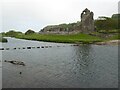
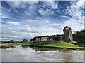
TheCaptain visited on 10th Oct 2018 Day out exploring the south Wales coast. On the way back, stop off at Ogmore Castle, gleaming orange in the setting sun. Within the castle is mounted a stone which clearly has carvings on it, but in the dark shadow of the castle walls, it was impossible to make anything out clearly.
coin have visited here
")
It is part of an early 11th C. shaft of a cross-slab, with inscriptions on both faces (enclosed by triple-moulded borders).
Supposedly, the inscription reads: EST / QUOD.DED[IT] / ARTHMAIL /AGRUM DO / ET GLIGUIS. / ET NERTAT ET FILIE : SU[A]
You may be viewing yesterday's version of this page. To see the most up to date information please register for a free account.
")
")
Do not use the above information on other web sites or publications without permission of the contributor.
Nearby Images from Geograph Britain and Ireland:
©2021(licence)

©2011(licence)
©2023(licence)
©2016(licence)
©2020(licence)
The above images may not be of the site on this page, they are loaded from Geograph.
Please Submit an Image of this site or go out and take one for us!
Click here to see more info for this site
Nearby sites
Key: Red: member's photo, Blue: 3rd party photo, Yellow: other image, Green: no photo - please go there and take one, Grey: site destroyed
Download sites to:
KML (Google Earth)
GPX (GPS waypoints)
CSV (Garmin/Navman)
CSV (Excel)
To unlock full downloads you need to sign up as a Contributory Member. Otherwise downloads are limited to 50 sites.
Turn off the page maps and other distractions
Nearby sites listing. In the following links * = Image available
1.3km NNE 32° Chapel Hill Camp Hillfort (SS88887806)
1.9km S 171° Heol y Mynydd Round Barrow* Round Barrow(s) (SS8841275126)
2.0km WNW 298° Cae Summerhouse* Ancient Village or Settlement (SS86397798)
2.3km W 269° Merthyr Mawr Warren 3 Cairn (SS859770)
2.7km W 265° Merthyr Mawr Warren 2 Cairn (SS855768)
2.8km NW 322° Tythegston* Chambered Tomb (SS86467925)
3.2km W 269° Merthyr Mawr Warren 1 Cairn (SS850770)
3.2km NE 38° Bridgend Recreation Centre* Standing Stone (Menhir) (SS90217951)
4.0km N 350° Cae'r-hen-Eglwys* Standing Stones (SS8753380886)
4.2km NW 312° Mynydd Herbert* Round Barrow(s) (SS85137983)
4.2km S 172° Dunraven* Hillfort (SS887728)
4.5km W 273° St John's Well (South Glamorgan)* Holy Well or Sacred Spring (SS8366877335)
4.6km W 273° St John's Well (Newton)* Holy Well or Sacred Spring (SS836773)
5.2km NW 326° Ty Du Stone or Scratching Post?* Standing Stone (Menhir) (SS85338133)
5.3km NE 36° Pond Cairn* Ring Cairn (SS914812)
5.5km SSE 162° Cwm Bach Hillfort Hillfort (SS89727175)
5.6km WNW 297° Mount Pleasant, Newton Nottage Round Cairn (SS83257960)
5.7km N 351° Cefn Cribbwr* Standing Stone (Menhir) (SS8738882634)
5.7km NE 46° Simondston Cairn* Cairn (SS92378088)
5.8km NE 42° Bronze Age cremation cemetery, Coity Link Road Marker Stone (SS922812)
6.0km W 279° Ffynnon Fawr* Holy Well or Sacred Spring (SS82227808)
6.3km WNW 284° St David's Well (South Glamorgan)* Holy Well or Sacred Spring (SS8203578604)
6.4km ENE 64° St Crallog (Coychurch)* Ancient Cross (SS93997970)
6.4km ENE 64° Ebissar Stone* Ancient Cross (SS93997971)
6.7km NE 41° Coity* Chambered Cairn (SS92698193)
View more nearby sites and additional images


 We would like to know more about this location. Please feel free to add a brief description and any relevant information in your own language.
 Wir möchten mehr über diese Stätte erfahren. Bitte zögern Sie nicht, eine kurze Beschreibung und relevante Informationen in Deutsch hinzuzufügen.
 Nous aimerions en savoir encore un peu sur les lieux. S'il vous plaît n'hesitez pas à ajouter une courte description et tous les renseignements pertinents dans votre propre langue.
 Quisieramos informarnos un poco más de las lugares. No dude en añadir una breve descripción y otros datos relevantes en su propio idioma.