<< Our Photo Pages >> Templand Mains - Standing Stone (Menhir) in Scotland in Dumfries and Galloway
Submitted by markj99 on Thursday, 11 July 2019 Page Views: 1810
Neolithic and Bronze AgeSite Name: Templand MainsCountry: Scotland County: Dumfries and Galloway Type: Standing Stone (Menhir)
Nearest Town: Thornhill
Map Ref: NX87719396
Latitude: 55.227043N Longitude: 3.766965W
Condition:
| 5 | Perfect |
| 4 | Almost Perfect |
| 3 | Reasonable but with some damage |
| 2 | Ruined but still recognisable as an ancient site |
| 1 | Pretty much destroyed, possibly visible as crop marks |
| 0 | No data. |
| -1 | Completely destroyed |
| 5 | Superb |
| 4 | Good |
| 3 | Ordinary |
| 2 | Not Good |
| 1 | Awful |
| 0 | No data. |
| 5 | Can be driven to, probably with disabled access |
| 4 | Short walk on a footpath |
| 3 | Requiring a bit more of a walk |
| 2 | A long walk |
| 1 | In the middle of nowhere, a nightmare to find |
| 0 | No data. |
| 5 | co-ordinates taken by GPS or official recorded co-ordinates |
| 4 | co-ordinates scaled from a detailed map |
| 3 | co-ordinates scaled from a bad map |
| 2 | co-ordinates of the nearest village |
| 1 | co-ordinates of the nearest town |
| 0 | no data |
Internal Links:
External Links:
I have visited· I would like to visit
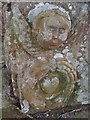
markj99 visited on 18th Apr 2022 - their rating: Cond: 3 Amb: 4 Access: 3 Templand Standing Stone is remarkable for its unusual shape, resembling a low slung bucket seat chair. The SW face of the stone is smooth, possibly as a result of many people sitting in the stone.
")
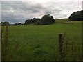
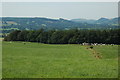
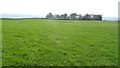
Templand Mains Standing Stone is located in a large field around 400 metres from a narrow lane passing Templand Mains farm. It is an unusual stone, 5 feet high and chair shaped.
Canmore ID 65264 states it is the "remains of a stone circle which gives its name to the farm 'Temple-land' on which it stands (Scots Mag 1806) Two of the stones were still standing in 1806 (R M F Watson 1901) and one in 1913."
Turn right onto the B731 just before you reach Thornhill via the A702 from Penpont. After around 1 mile on the B731 you reach a Y junction. Take the second right towards Templand Cottages for around 500 metres to a wide gateway to park off the road. The stone is visible on the right side.
You may be viewing yesterday's version of this page. To see the most up to date information please register for a free account.
")
")
")
")
Do not use the above information on other web sites or publications without permission of the contributor.
Nearby Images from Geograph Britain and Ireland:
©2009(licence)
©2006(licence)
©2019(licence)
©2009(licence)
©2009(licence)
The above images may not be of the site on this page, they are loaded from Geograph.
Please Submit an Image of this site or go out and take one for us!
Click here to see more info for this site
Nearby sites
Key: Red: member's photo, Blue: 3rd party photo, Yellow: other image, Green: no photo - please go there and take one, Grey: site destroyed
Download sites to:
KML (Google Earth)
GPX (GPS waypoints)
CSV (Garmin/Navman)
CSV (Excel)
To unlock full downloads you need to sign up as a Contributory Member. Otherwise downloads are limited to 50 sites.
Turn off the page maps and other distractions
Nearby sites listing. In the following links * = Image available
1.7km NNW 330° Nith Bridge Cross* Ancient Cross (NX8689095471)
2.9km NNW 332° Penpont Cursus Cursus (NX86409658)
3.8km SSE 149° Kirkpatrick Hill (Closeburn) Holy Well or Sacred Spring (NX896906)
3.9km SE 138° My Lady's Well (Brownhill) Holy Well or Sacred Spring (NX90279100)
4.1km WSW 249° Capenoch* Cairn (NX8385092608)
5.3km W 281° Grennan Hill Hillfort (NX82549507)
5.7km W 268° Tynron Doon* Hillfort (NX8197093927)
6.4km WNW 303° Honeyhole White Cairn* Cairn (NX82389757)
7.0km SSW 198° Fleuchlarg White Cairn* Chambered Cairn (NX85438734)
7.4km N 8° Mary's Well (East Morton) Holy Well or Sacred Spring (NS88870123)
7.9km WSW 238° Glencairn Cursus Cursus (NX80948993)
8.6km E 93° Gulfhill Rig Cairn (NX963933)
9.6km SSW 193° White Cairn, Gilmerston Cairn (NX853847)
9.7km SSE 153° Temple Wood (Dunscore)* Modern Stone Circle etc (NX91848522)
9.8km SSE 168° Springfield Hill Hillfort (NX89448431)
10.0km SSW 211° West Skelston White Cairn* Cairn (NX82358551)
10.5km SSW 202° Glenesslin Schoolhouse* Cairn (NX83488433)
11.3km SE 131° Clonfeckle Cairn (NX960863)
12.3km W 274° St. Conal's Well* Holy Well or Sacred Spring (NX75399508)
14.1km SE 140° Kirkmahoe Cursus Cursus (NX96508286)
14.4km SSE 163° Holywood Cursus Cursus (NX91558004)
14.7km SSE 167° Hall Hill* Hillfort (NX90597949)
15.1km WSW 239° Physic Well (Balmaclellan) Holy Well or Sacred Spring (NX7452586502)
15.6km SSE 150° Holywood B Cursus Cursus (NX951802)
15.7km ENE 68° Lonnachie Rig Cairn (NY024995)
View more nearby sites and additional images


 We would like to know more about this location. Please feel free to add a brief description and any relevant information in your own language.
 Wir möchten mehr über diese Stätte erfahren. Bitte zögern Sie nicht, eine kurze Beschreibung und relevante Informationen in Deutsch hinzuzufügen.
 Nous aimerions en savoir encore un peu sur les lieux. S'il vous plaît n'hesitez pas à ajouter une courte description et tous les renseignements pertinents dans votre propre langue.
 Quisieramos informarnos un poco más de las lugares. No dude en añadir una breve descripción y otros datos relevantes en su propio idioma.