

<< Our Photo Pages >> Lluest Aber Caethon Mound - Round Barrow(s) in Wales in Powys
Submitted by elanvalleypastandpre on Friday, 06 August 2021 Page Views: 240
Neolithic and Bronze AgeSite Name: Lluest Aber Caethon MoundCountry: Wales County: Powys Type: Round Barrow(s)
Nearest Town: Rhayader Nearest Village: Elan Village
Map Ref: SN87146876
Latitude: 52.305323N Longitude: 3.656694W
Condition:
| 5 | Perfect |
| 4 | Almost Perfect |
| 3 | Reasonable but with some damage |
| 2 | Ruined but still recognisable as an ancient site |
| 1 | Pretty much destroyed, possibly visible as crop marks |
| 0 | No data. |
| -1 | Completely destroyed |
| 5 | Superb |
| 4 | Good |
| 3 | Ordinary |
| 2 | Not Good |
| 1 | Awful |
| 0 | No data. |
| 5 | Can be driven to, probably with disabled access |
| 4 | Short walk on a footpath |
| 3 | Requiring a bit more of a walk |
| 2 | A long walk |
| 1 | In the middle of nowhere, a nightmare to find |
| 0 | No data. |
| 5 | co-ordinates taken by GPS or official recorded co-ordinates |
| 4 | co-ordinates scaled from a detailed map |
| 3 | co-ordinates scaled from a bad map |
| 2 | co-ordinates of the nearest village |
| 1 | co-ordinates of the nearest town |
| 0 | no data |
Internal Links:
External Links:
")
You may be viewing yesterday's version of this page. To see the most up to date information please register for a free account.
")
Do not use the above information on other web sites or publications without permission of the contributor.
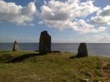
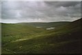
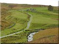
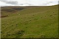
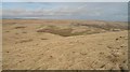
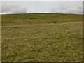
Nearby Images from Geograph Britain and Ireland:
©2007(licence)
©2007(licence)
©2007(licence)
©2009(licence)
©2007(licence)
The above images may not be of the site on this page, they are loaded from Geograph.
Please Submit an Image of this site or go out and take one for us!
Click here to see more info for this site
Nearby sites
Key: Red: member's photo, Blue: 3rd party photo, Yellow: other image, Green: no photo - please go there and take one, Grey: site destroyed
Download sites to:
KML (Google Earth)
GPX (GPS waypoints)
CSV (Garmin/Navman)
CSV (Excel)
To unlock full downloads you need to sign up as a Contributory Member. Otherwise downloads are limited to 50 sites.
Turn off the page maps and other distractions
Nearby sites listing. In the following links * = Image available
458m ENE 79° Lluest Aber Caethon Ring Cairn* Ring Cairn (SN8759268841)
610m WNW 290° Esgair Beddau Cairn 2* Round Barrow(s) (SN8657068982)
653m WNW 291° Esgair Beddau Cairn 1* Round Barrow(s) (SN8653469009)
983m NW 321° Esgair Y Ty Cairn* Cairn (SN86546954)
1.2km ESE 119° Esgair Gris Cairn* Cairn (SN88166817)
2.7km SE 140° Cefn Troed Rhiw Drain Cist* Cist (SN88816667)
3.9km SSW 196° Cerrig-Y-Gadeir* Cairn (SN860650)
4.3km SE 144° Cefn Cwm-Coel Cist* Cist (SN89636519)
4.4km E 98° Esgair Pen-y-Garreg* Stone Row / Alignment (SN9145468091)
4.8km ENE 62° Blaen Fign Cairn 2* Cairn (SN914709)
4.8km E 89° Crugyn Gwyddel Cairn* Cairn (SN91976877)
4.9km NNE 23° Banc Cynnydd Cairn 2* Cairn (SN89177318)
5.1km NNE 23° Banc Cynnydd Cairn* Cairn (SN89227338)
5.3km NW 309° Garreg Bica Standing Stone (Menhir) (SN8303372179)
5.6km ESE 116° Y Glog Fawr Cairn* Cairn (SN92156618)
5.7km ENE 70° Maengwyngweddew* Standing Stone (Menhir) (SN926706)
5.8km ESE 118° Beddau Folau Chambered Cairn* Cairn (SN922659)
5.9km NE 36° Cerrig Llwydion Round Barrow* Round Barrow(s) (SN90677345)
5.9km SSE 152° Llanerchi Mound* Cairn (SN89796351)
5.9km SSE 152° Cefn Llanerchi* Standing Stones (SN89836350)
5.9km E 87° Tre Heslog Cist* Cist (SN931689)
6.0km E 87° Tre Heslog Stone Row* Stone Row / Alignment (SN9310668922)
6.0km NNE 28° Carn Nant Y Ffald* Cairn (SN90057397)
6.0km NNE 30° Carn Wen (Rhiw Afon)* Cairn (SN90287384)
6.0km ESE 116° Glog Fawr Cairn* Cist (SN92486603)
View more nearby sites and additional images


 We would like to know more about this location. Please feel free to add a brief description and any relevant information in your own language.
 Wir möchten mehr über diese Stätte erfahren. Bitte zögern Sie nicht, eine kurze Beschreibung und relevante Informationen in Deutsch hinzuzufügen.
 Nous aimerions en savoir encore un peu sur les lieux. S'il vous plaît n'hesitez pas à ajouter une courte description et tous les renseignements pertinents dans votre propre langue.
 Quisieramos informarnos un poco más de las lugares. No dude en añadir una breve descripción y otros datos relevantes en su propio idioma.