

<< Our Photo Pages >> Carn Twrch - Cairn in Wales in Carmarthenshire
Submitted by geoffstickland on Sunday, 28 June 2020 Page Views: 706
Neolithic and Bronze AgeSite Name: Carn TwrchCountry: Wales County: Carmarthenshire Type: Cairn
Nearest Town: Llandovery Nearest Village: Rhandirmwyn
Map Ref: SN80344630
Latitude: 52.102052N Longitude: 3.748435W
Condition:
| 5 | Perfect |
| 4 | Almost Perfect |
| 3 | Reasonable but with some damage |
| 2 | Ruined but still recognisable as an ancient site |
| 1 | Pretty much destroyed, possibly visible as crop marks |
| 0 | No data. |
| -1 | Completely destroyed |
| 5 | Superb |
| 4 | Good |
| 3 | Ordinary |
| 2 | Not Good |
| 1 | Awful |
| 0 | No data. |
| 5 | Can be driven to, probably with disabled access |
| 4 | Short walk on a footpath |
| 3 | Requiring a bit more of a walk |
| 2 | A long walk |
| 1 | In the middle of nowhere, a nightmare to find |
| 0 | No data. |
| 5 | co-ordinates taken by GPS or official recorded co-ordinates |
| 4 | co-ordinates scaled from a detailed map |
| 3 | co-ordinates scaled from a bad map |
| 2 | co-ordinates of the nearest village |
| 1 | co-ordinates of the nearest town |
| 0 | no data |
Internal Links:
External Links:
I have visited· I would like to visit
geoffstickland has visited here
")
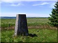
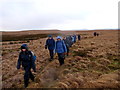
Set on the highest local point, the grass covered cairn seems to have been undisturbed. About 40' across and 6' high, there is an OS Trig Point in the middle of the cairn. There are extensive views to the north and mature, commercial forestry on its other sides.
Coflein site no. 304668
(A sad tale - to my chagrin, I got so excited photographing the trig point that I forget to photograph the cairn itself. I must now retrace the lengthy journey to capture the cairn on film.)
You may be viewing yesterday's version of this page. To see the most up to date information please register for a free account.
")
Do not use the above information on other web sites or publications without permission of the contributor.
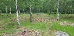
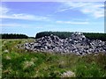
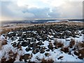
Nearby Images from Geograph Britain and Ireland:
©2008(licence)
©2008(licence)
©2015(licence)
©2014(licence)
©2009(licence)
The above images may not be of the site on this page, they are loaded from Geograph.
Please Submit an Image of this site or go out and take one for us!
Click here to see more info for this site
Nearby sites
Key: Red: member's photo, Blue: 3rd party photo, Yellow: other image, Green: no photo - please go there and take one, Grey: site destroyed
Download sites to:
KML (Google Earth)
GPX (GPS waypoints)
CSV (Garmin/Navman)
CSV (Excel)
To unlock full downloads you need to sign up as a Contributory Member. Otherwise downloads are limited to 50 sites.
Turn off the page maps and other distractions
Nearby sites listing. In the following links * = Image available
290m NW 315° Cerrig Cedny* Cairn (SN80144651)
503m S 172° Carreg Craig y Moch Standing Stone (Menhir) (SN804458)
1.1km SSW 205° Carn Wen (Rhandirmwyn)* Cairn (SN79834527)
1.7km NNE 30° Cefn Ystrad Ffin Cairn* Cairn (SN81234776)
2.1km ESE 123° Cynant Fach Cairn* Cairn (SN82054515)
2.2km S 185° Cerrig Cynant* Stone Circle (SN80114411)
2.5km S 185° Bryn Poeth Uchaf (North & South)* Ring Cairn (SN80054382)
2.7km NE 47° Croes Llywd Fach Cairn* Cairn (SN82374808)
2.7km ENE 71° Cnapau Hafodllewelyn Cairn* Cairn (SN82934711)
2.7km W 262° Ty Newydd Standing Stone* Standing Stone (Menhir) (SN776460)
2.8km NNE 31° Mynydd Trawsnant Cairn* Cairn (SN81834863)
3.3km W 261° Gelli Burial Chamber* Chambered Cairn (SN7703845843)
3.4km SSW 196° Garreg Garn Fair* Standing Stone (Menhir) (SN79334310)
3.4km SSW 196° Garn fawr (Carmarthenshire)* Cairn (SN79334304)
3.8km SSE 162° Maes Mynach Cairn Cemetery - Cwm Lwnor Cairn (SN81404266)
3.9km SSE 156° Maes Mynach Cairn Cemetery - Cwm Lwyndr Cairn Cairn (SN81844266)
4.1km SW 218° Dinas Bach (Cilycwm)* Hillfort (SN77704310)
4.4km S 187° Cae Pentwyr* Cairn (SN79674196)
4.4km E 85° Waun Coli* Cairn (SN84754658)
4.4km E 93° Garn Wen (Llanwrtyd Wells)* Cairn (SN84754597)
4.5km NE 36° Esgair Garn* Cairn (SN83084983)
4.5km NE 43° Cefn Blaencwmhenog Cairn* Cairn (SN8349449500)
4.6km W 277° Randirmwyn Standing Stone* Standing Stone (Menhir) (SN758470)
4.7km SSW 200° Pen Rhiw'r Onen Cairn* Cairn (SN78604197)
4.7km SE 137° Sugar Loaf Hill Fort* Hillfort (SN83484278)
View more nearby sites and additional images


 We would like to know more about this location. Please feel free to add a brief description and any relevant information in your own language.
 Wir möchten mehr über diese Stätte erfahren. Bitte zögern Sie nicht, eine kurze Beschreibung und relevante Informationen in Deutsch hinzuzufügen.
 Nous aimerions en savoir encore un peu sur les lieux. S'il vous plaît n'hesitez pas à ajouter une courte description et tous les renseignements pertinents dans votre propre langue.
 Quisieramos informarnos un poco más de las lugares. No dude en añadir una breve descripción y otros datos relevantes en su propio idioma.