<< Other Photo Pages >> Copa Hill Opencast Mine - Ancient Mine, Quarry or other Industry in Wales in Ceredigion
Submitted by Anonymous on Saturday, 08 June 2024 Page Views: 330
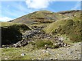
Multi-periodSite Name: Copa Hill Opencast Mine Alternative Name: Bryn CopaCountry: Wales
NOTE: This site is 2.3 km away from the location you searched for.
County: Ceredigion Type: Ancient Mine, Quarry or other Industry
Nearest Village: Cwmystwyth
Map Ref: SN8116075220
Latitude: 52.362110N Longitude: 3.746644W
Condition:
| 5 | Perfect |
| 4 | Almost Perfect |
| 3 | Reasonable but with some damage |
| 2 | Ruined but still recognisable as an ancient site |
| 1 | Pretty much destroyed, possibly visible as crop marks |
| 0 | No data. |
| -1 | Completely destroyed |
| 5 | Superb |
| 4 | Good |
| 3 | Ordinary |
| 2 | Not Good |
| 1 | Awful |
| 0 | No data. |
| 5 | Can be driven to, probably with disabled access |
| 4 | Short walk on a footpath |
| 3 | Requiring a bit more of a walk |
| 2 | A long walk |
| 1 | In the middle of nowhere, a nightmare to find |
| 0 | No data. |
| 5 | co-ordinates taken by GPS or official recorded co-ordinates |
| 4 | co-ordinates scaled from a detailed map |
| 3 | co-ordinates scaled from a bad map |
| 2 | co-ordinates of the nearest village |
| 1 | co-ordinates of the nearest town |
| 0 | no data |
Internal Links:
External Links:
")
Extensive archaeological survey work and investigation was carried out from 1986 to 1999. The earliest mining may have been commenced around 2500BC with surface collection of minerals and undercutting with fire used to excavate the rock and break up the copper ore. By 2000BC opencast mining was being carried out from the down-slope end of the trench, with the mine reaching its maximum depth about a hundred years later. Over the next two to three hundred years, following abandonment of the deeper sections of the mine due to water-logging, the mine continued to be worked upslope (northwards) on a more piecemeal basis. The mine was finally abandoned in 1600BC.
Source: coflein.gov.uk/en/site/33834/
See also: earlyminesresearchgroup.co.uk/comet%20lode%20-%20copa%20hill.html
WARNING: There are very dangerous open mine workings on the way up. Visiting without a guide who knows the area is not recommended.
You may be viewing yesterday's version of this page. To see the most up to date information please register for a free account.
")
")
")
")
Do not use the above information on other web sites or publications without permission of the contributor.
Nearby Images from Geograph Britain and Ireland:
©2016(licence)

©2016(licence)

©2023(licence)

©2014(licence)

©2015(licence)
The above images may not be of the site on this page, they are loaded from Geograph.
Please Submit an Image of this site or go out and take one for us!
Click here to see more info for this site
Nearby sites
Key: Red: member's photo, Blue: 3rd party photo, Yellow: other image, Green: no photo - please go there and take one, Grey: site destroyed
Download sites to:
KML (Google Earth)
GPX (GPS waypoints)
CSV (Garmin/Navman)
CSV (Excel)
To unlock full downloads you need to sign up as a Contributory Member. Otherwise downloads are limited to 50 sites.
Turn off the page maps and other distractions
Nearby sites listing. In the following links * = Image available
3.3km S 184° Domen Milwyn Cairn* Round Barrow(s) (SN8083271967)
3.6km SSE 147° Garreg Bica Standing Stone (Menhir) (SN8303372179)
4.5km E 82° Maen Hir Stone* Standing Stone (Menhir) (SN85597577)
4.6km E 80° Maen Hir Cairn Cemetery* Barrow Cemetery (SN85757592)
4.9km E 81° Glan Fedwen Cairn 2* Cairn (SN86027588)
5.0km E 81° Glan Fedwen Cairn 1* Cairn (SN86147585)
5.2km SSW 202° Carn-Y-Rhyrddod* Cairn (SN7906670426)
5.5km ENE 71° Cistfaen Barrow 2* Round Barrow(s) (SN86407685)
5.5km ENE 70° Cistfaen Cairn 1* Cairn (SN86367701)
5.5km ENE 69° Cistfaen Cairn 2* Cairn (SN86367704)
5.5km SSW 194° Carreg Naw Llyn* Standing Stone (Menhir) (SN79716989)
5.6km ENE 71° Cistfaen Barrow 1* Cist (SN86477694)
5.8km SSW 203° Llan Ddu Fawr Cairn* Cairn (SN78766998)
5.8km SSW 199° Waun Claerddu Cist* Cist (SN79106980)
5.8km SSW 213° Blaen Marchnant Cairn (SN77857040)
6.6km E 89° Blaen Clawdd Du Cairn* Cairn (SN87767517)
6.6km SSW 196° Craig Fawr Cairn (SN792689)
7.0km ENE 78° Carn Y Groes* Cairn (SN88077645)
7.0km WNW 302° Ysbyty Cynfyn* Stone Circle (SN75257908)
7.2km WNW 283° Devil's Punch Bowl* Natural Stone / Erratic / Other Natural Feature (SN7417177025)
7.7km WNW 300° Dolgamfa* Round Cairn (SN7457279172)
7.8km SE 135° Esgair Y Ty Cairn* Cairn (SN86546954)
8.2km SE 138° Esgair Beddau Cairn 1* Round Barrow(s) (SN8653469009)
8.2km ESE 103° Banc Cynnydd Cairn 2* Cairn (SN89177318)
8.2km ESE 102° Banc Cynnydd Cairn* Cairn (SN89227338)
View more nearby sites and additional images


 We would like to know more about this location. Please feel free to add a brief description and any relevant information in your own language.
 Wir möchten mehr über diese Stätte erfahren. Bitte zögern Sie nicht, eine kurze Beschreibung und relevante Informationen in Deutsch hinzuzufügen.
 Nous aimerions en savoir encore un peu sur les lieux. S'il vous plaît n'hesitez pas à ajouter une courte description et tous les renseignements pertinents dans votre propre langue.
 Quisieramos informarnos un poco más de las lugares. No dude en añadir una breve descripción y otros datos relevantes en su propio idioma.