<< Text Pages >> Croft Moraig Carving 1 - Rock Art in Scotland in Perth and Kinross
Submitted by Anne T on Tuesday, 01 August 2017 Page Views: 1539
Rock ArtSite Name: Croft Moraig Carving 1 Alternative Name: Croftmoraig CarvingCountry: Scotland County: Perth and Kinross Type: Rock Art
Nearest Town: Aberfeldy Nearest Village: Stix
Map Ref: NN7974647251
Latitude: 56.601677N Longitude: 3.960381W
Condition:
| 5 | Perfect |
| 4 | Almost Perfect |
| 3 | Reasonable but with some damage |
| 2 | Ruined but still recognisable as an ancient site |
| 1 | Pretty much destroyed, possibly visible as crop marks |
| 0 | No data. |
| -1 | Completely destroyed |
| 5 | Superb |
| 4 | Good |
| 3 | Ordinary |
| 2 | Not Good |
| 1 | Awful |
| 0 | No data. |
| 5 | Can be driven to, probably with disabled access |
| 4 | Short walk on a footpath |
| 3 | Requiring a bit more of a walk |
| 2 | A long walk |
| 1 | In the middle of nowhere, a nightmare to find |
| 0 | No data. |
| 5 | co-ordinates taken by GPS or official recorded co-ordinates |
| 4 | co-ordinates scaled from a detailed map |
| 3 | co-ordinates scaled from a bad map |
| 2 | co-ordinates of the nearest village |
| 1 | co-ordinates of the nearest town |
| 0 | no data |
Be the first person to rate this site - see the 'Contribute!' box in the right hand menu.
Internal Links:
External Links:
Rock Art in Perth and Kinross
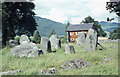
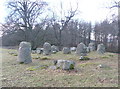
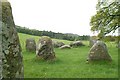
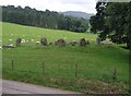
Rock art around the nearby Croft Moraig stone circle is recorded together with information on the stone circle on Canmore ID 24891, who in turn reference Megalithics Website for photographs of the rock art.
This particular cup and ring marked rock, which contains around 19 cups, is featured on The Northern Antiquarian (TNA) - see their page for Croft Moraig Carving (01), Kenmore, Perthshire. Their page gives directions for finding the boulder, together with photographs, a 1910 drawing, references and a brief archaeology and history.
Note: Have you visited this site? Do you have any more information or photographs you can add?
You may be viewing yesterday's version of this page. To see the most up to date information please register for a free account.
Do not use the above information on other web sites or publications without permission of the contributor.
Nearby Images from Geograph Britain and Ireland:
©2014(licence)
©2011(licence)
©2007(licence)
©2005(licence)
©2010(licence)
The above images may not be of the site on this page, they are loaded from Geograph.
Please Submit an Image of this site or go out and take one for us!
Click here to see more info for this site
Nearby sites
Key: Red: member's photo, Blue: 3rd party photo, Yellow: other image, Green: no photo - please go there and take one, Grey: site destroyed
Download sites to:
KML (Google Earth)
GPX (GPS waypoints)
CSV (Garmin/Navman)
CSV (Excel)
To unlock full downloads you need to sign up as a Contributory Member. Otherwise downloads are limited to 50 sites.
Turn off the page maps and other distractions
Nearby sites listing. In the following links * = Image available
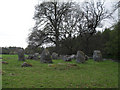
31m NE 50° Croft Moraig* Stone Circle (NN79774727)
571m NE 37° Taymouth (2) Standing Stones (NN801477)
708m SW 217° Taymouth (1)* Standing Stones (NN793467)
963m E 97° St Adamnan's Well* Holy Well or Sacred Spring (NN807471)
1.1km WSW 245° Comrie Bridge Stone Circle (NN787468)
1.1km W 266° An Tobar* Holy Well or Sacred Spring (NN786472)
1.1km N 356° Tirinie Farm Circle Stone Circle (NN797484)
1.1km N 1° Tirinie Farm Barrow Round Barrow(s) (NN798484)
1.3km NNE 22° Carse Farm 2* Stone Circle (NN80284846)
1.6km NNE 16° Carse Farm I* Stone Circle (NN80224873)
1.9km NNE 15° Appin of Dull* Rock Art (NN803491)
2.0km NNE 29° Dull Cairn* Cairn (NN808490)
2.1km NNE 25° Dull Cross (Aberfeldy) Ancient Cross (NN8070649135)
2.2km SSW 195° Tombuie Cottage* Rock Art (NN791451)
2.5km NE 37° Nether Tullicro* Standing Stone (Menhir) (NN81294916)
2.7km SE 143° Craig Hill* Rock Art (NN81334506)
3.2km SW 227° Spar Island* Crannog (NN773451)
3.3km NE 51° Balhomais* Stone Circle (NN82384926)
3.6km SW 227° Scottish Crannog Centre* Museum (NN7704444910)
3.8km NNE 32° Lurgan* Rock Art (NN8185550425)
3.9km NE 55° Weem Cursus Cursus (NN83044939)
4.4km SSW 213° Balmacnaughton* Rock Art (NN7729043649)
4.8km E 96° Coilleachur Stone Circle (NN845466)
4.9km E 88° An Torr* Rock Art (NN84694729)
5.1km ENE 57° Weem Woods (Dull)* Rock Art (NN841499)
View more nearby sites and additional images


 We would like to know more about this location. Please feel free to add a brief description and any relevant information in your own language.
 Wir möchten mehr über diese Stätte erfahren. Bitte zögern Sie nicht, eine kurze Beschreibung und relevante Informationen in Deutsch hinzuzufügen.
 Nous aimerions en savoir encore un peu sur les lieux. S'il vous plaît n'hesitez pas à ajouter une courte description et tous les renseignements pertinents dans votre propre langue.
 Quisieramos informarnos un poco más de las lugares. No dude en añadir una breve descripción y otros datos relevantes en su propio idioma.