


<< Our Photo Pages >> Dalgrambich Farm - Standing Stones in Scotland in Highlands
Submitted by mattchapman on Friday, 22 January 2016 Page Views: 3103
Neolithic and Bronze AgeSite Name: Dalgrambich FarmCountry: Scotland
NOTE: This site is 3.7 km away from the location you searched for.
County: Highlands Type: Standing Stones
Nearest Town: Inverness Nearest Village: Croy
Map Ref: NH79104715
Latitude: 57.498374N Longitude: 4.019005W
Condition:
| 5 | Perfect |
| 4 | Almost Perfect |
| 3 | Reasonable but with some damage |
| 2 | Ruined but still recognisable as an ancient site |
| 1 | Pretty much destroyed, possibly visible as crop marks |
| 0 | No data. |
| -1 | Completely destroyed |
| 5 | Superb |
| 4 | Good |
| 3 | Ordinary |
| 2 | Not Good |
| 1 | Awful |
| 0 | No data. |
| 5 | Can be driven to, probably with disabled access |
| 4 | Short walk on a footpath |
| 3 | Requiring a bit more of a walk |
| 2 | A long walk |
| 1 | In the middle of nowhere, a nightmare to find |
| 0 | No data. |
| 5 | co-ordinates taken by GPS or official recorded co-ordinates |
| 4 | co-ordinates scaled from a detailed map |
| 3 | co-ordinates scaled from a bad map |
| 2 | co-ordinates of the nearest village |
| 1 | co-ordinates of the nearest town |
| 0 | no data |
Internal Links:
External Links:
")
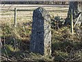
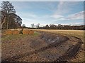
About 6.5 to 7 foot tall the story given to me was that
the farmer's ( he was Seventy odd ) father had had some men ploughing the land when the plough encountered this stone lying prostrate. The workers where in the act of dragging it to the river Nairn to dump it when his father saw what was happening and stopped them with the warning that the stone must never leave the field for fear of bad luck striking the farm.
So the stone was re erected where it stands in the corner of the field.
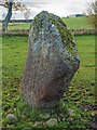
Just to the south of this is a smaller stone that seems roughly dressed but is to large for a gate post and not by any obvious entry to a field. May be they formed a back marker and for sight for astronomical observation as the distant horizon is remarkably level. But with out the larger stones original position, who knows.
You may be viewing yesterday's version of this page. To see the most up to date information please register for a free account.
")
")
Do not use the above information on other web sites or publications without permission of the contributor.
Nearby Images from Geograph Britain and Ireland:
©2016(licence)
©2016(licence)
©2016(licence)
©2017(licence)
©2016(licence)
The above images may not be of the site on this page, they are loaded from Geograph.
Please Submit an Image of this site or go out and take one for us!
Click here to see more info for this site
Nearby sites
Key: Red: member's photo, Blue: 3rd party photo, Yellow: other image, Green: no photo - please go there and take one, Grey: site destroyed
Download sites to:
KML (Google Earth)
GPX (GPS waypoints)
CSV (Garmin/Navman)
CSV (Excel)
To unlock full downloads you need to sign up as a Contributory Member. Otherwise downloads are limited to 50 sites.
Turn off the page maps and other distractions
Nearby sites listing. In the following links * = Image available
1.7km NW 315° Dalcross Mains* Stone Circle (NH779484)
4.0km SW 228° Mains of Clava SE* Cairn (NH76054457)
4.2km SW 231° Balnuaran of Clava (Stone)* Standing Stone (Menhir) (NH758446)
4.3km SW 230° Balnuaran Of Clava NE* Clava Cairn (NH7576744478)
4.3km SW 228° Balnuaran of Clava E* Clava Cairn (NH75804435)
4.3km SW 229° Balnuaran of Clava Centre* Ring Cairn (NH7572044438)
4.4km SW 230° Balnuaran of Clava Kerb Cairn* Cairn (NH7567444422)
4.4km SW 229° Balnuaran of Clava SW* Clava Cairn (NH7568944380)
4.5km WSW 244° Cumberland's Stone* Natural Stone / Erratic / Other Natural Feature (NH74974526)
5.0km SW 229° Milltown Of Clava* Cairn (NH7525043971)
5.2km SW 228° Culdoich* Ring Cairn (NH75114378)
5.2km WSW 244° The Well of The Dead* Holy Well or Sacred Spring (NH7431844971)
5.5km WSW 239° Leanach NE Chambered Cairn (NH74344444)
5.5km WSW 238° Leanach Stone Circle (NH743444)
5.6km SW 218° Culdoich S Stone Circle (NH755428)
5.7km WSW 237° Culchunaig* Stone Circle (NH74194416)
5.8km WNW 283° Newton Of Petty Ring Cairn (NH73484858)
6.6km W 273° Cullearnie* Stone Circle (NH72504768)
6.8km NNE 29° Loch of the Clans Crannog* Crannog (NH82575297)
7.0km WSW 253° St Mary's Well (Culloden)* Holy Well or Sacred Spring (NH723453)
7.4km SW 230° Forrest Cottage* Chambered Cairn (NH733426)
7.5km W 272° Allanfearn* Chambered Cairn (NH716476)
7.5km ENE 59° Cawdor* Standing Stone (Menhir) (NH857508)
7.7km ENE 78° Little Urchany* Clava Cairn (NH8665648566)
8.4km W 267° Milton Stone Row Stone Row / Alignment (NH70704690)
View more nearby sites and additional images


 We would like to know more about this location. Please feel free to add a brief description and any relevant information in your own language.
 Wir möchten mehr über diese Stätte erfahren. Bitte zögern Sie nicht, eine kurze Beschreibung und relevante Informationen in Deutsch hinzuzufügen.
 Nous aimerions en savoir encore un peu sur les lieux. S'il vous plaît n'hesitez pas à ajouter une courte description et tous les renseignements pertinents dans votre propre langue.
 Quisieramos informarnos un poco más de las lugares. No dude en añadir una breve descripción y otros datos relevantes en su propio idioma.