


<< Our Photo Pages >> Balmacnaughton - Rock Art in Scotland in Perth and Kinross
Submitted by tiompan on Saturday, 11 February 2012 Page Views: 4208
Rock ArtSite Name: BalmacnaughtonCountry: Scotland County: Perth and Kinross Type: Rock Art
Map Ref: NN7729043649
Latitude: 56.568700N Longitude: 3.998651W
Condition:
| 5 | Perfect |
| 4 | Almost Perfect |
| 3 | Reasonable but with some damage |
| 2 | Ruined but still recognisable as an ancient site |
| 1 | Pretty much destroyed, possibly visible as crop marks |
| 0 | No data. |
| -1 | Completely destroyed |
| 5 | Superb |
| 4 | Good |
| 3 | Ordinary |
| 2 | Not Good |
| 1 | Awful |
| 0 | No data. |
| 5 | Can be driven to, probably with disabled access |
| 4 | Short walk on a footpath |
| 3 | Requiring a bit more of a walk |
| 2 | A long walk |
| 1 | In the middle of nowhere, a nightmare to find |
| 0 | No data. |
| 5 | co-ordinates taken by GPS or official recorded co-ordinates |
| 4 | co-ordinates scaled from a detailed map |
| 3 | co-ordinates scaled from a bad map |
| 2 | co-ordinates of the nearest village |
| 1 | co-ordinates of the nearest town |
| 0 | no data |
Internal Links:
External Links:
")
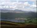
Cup and ring marked site above Kenmore.
You may be viewing yesterday's version of this page. To see the most up to date information please register for a free account.
")
")
")
Do not use the above information on other web sites or publications without permission of the contributor.
Nearby Images from Geograph Britain and Ireland:
©2005(licence)
©2016(licence)

©2014(licence)
©2015(licence)

©2025(licence)
The above images may not be of the site on this page, they are loaded from Geograph.
Please Submit an Image of this site or go out and take one for us!
Click here to see more info for this site
Nearby sites
Key: Red: member's photo, Blue: 3rd party photo, Yellow: other image, Green: no photo - please go there and take one, Grey: site destroyed
Download sites to:
KML (Google Earth)
GPX (GPS waypoints)
CSV (Garmin/Navman)
CSV (Excel)
To unlock full downloads you need to sign up as a Contributory Member. Otherwise downloads are limited to 50 sites.
Turn off the page maps and other distractions
Nearby sites listing. In the following links * = Image available
1.2km SW 229° Queen's Wood (Acharn) Rock Art (NN76404291)
1.3km SSW 202° Acharn Falls* Stone Circle (NN7678742495)
1.3km NNW 347° Scottish Crannog Centre* Museum (NN7704444910)
1.4km WSW 238° Acharn Burn* Cairn (NN76074294)
1.4km N 359° Spar Island* Crannog (NN773451)
2.3km NE 50° Tombuie Cottage* Rock Art (NN791451)
3.4km NNE 22° Comrie Bridge Stone Circle (NN787468)
3.6km NNE 32° Taymouth (1)* Standing Stones (NN793467)
3.8km NNE 19° An Tobar* Holy Well or Sacred Spring (NN786472)
4.3km NW 318° Fortingall S* Stone Circle (NN7454746927)
4.3km ENE 69° Craig Hill* Rock Art (NN81334506)
4.3km NW 319° Fortingall NE* Stone Circle (NN7453546977)
4.3km NW 318° Fortingall SW* Stone Circle (NN7451446960)
4.4km NNE 33° Croft Moraig Carving 1 Rock Art (NN7974647251)
4.4km NNE 33° Croft Moraig* Stone Circle (NN79774727)
4.6km NW 316° Fortingall church crosses* Ancient Cross (NN74204702)
4.6km NW 314° Clach a' Phlaigh* Standing Stone (Menhir) (NN74064693)
4.8km NE 43° St Adamnan's Well* Holy Well or Sacred Spring (NN807471)
4.9km NW 312° Fortingall Modern Stone Circle* Modern Stone Circle etc (NN73754703)
4.9km NNE 33° Taymouth (2) Standing Stones (NN801477)
5.0km WNW 302° Bridge of Lyon Standing Stones* Standing Stones (NN73144641)
5.0km W 276° Oakbank Crannog* Crannog (NN723443)
5.0km WNW 304° Lyon Bridge Cairn* Cairn (NN73174657)
5.1km WNW 287° Cromrar 1* Rock Art (NN72474531)
5.1km WNW 284° Cromrar 2* Rock Art (NN72344507)
View more nearby sites and additional images


 We would like to know more about this location. Please feel free to add a brief description and any relevant information in your own language.
 Wir möchten mehr über diese Stätte erfahren. Bitte zögern Sie nicht, eine kurze Beschreibung und relevante Informationen in Deutsch hinzuzufügen.
 Nous aimerions en savoir encore un peu sur les lieux. S'il vous plaît n'hesitez pas à ajouter une courte description et tous les renseignements pertinents dans votre propre langue.
 Quisieramos informarnos un poco más de las lugares. No dude en añadir una breve descripción y otros datos relevantes en su propio idioma.