<< Our Photo Pages >> Ancient Footprints on Kenfig Beach - Ancient Village or Settlement in Wales in South Glamorgan
Submitted by Andy B on Monday, 14 February 2011 Page Views: 11717
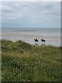
Mesolithic, Palaeolithic and EarlierSite Name: Ancient Footprints on Kenfig Beach Alternative Name: Kenfig SandsCountry: Wales County: South Glamorgan Type: Ancient Village or Settlement
Nearest Village: Kenfig
Map Ref: SS785807
Latitude: 51.512122N Longitude: 3.752266W
Condition:
| 5 | Perfect |
| 4 | Almost Perfect |
| 3 | Reasonable but with some damage |
| 2 | Ruined but still recognisable as an ancient site |
| 1 | Pretty much destroyed, possibly visible as crop marks |
| 0 | No data. |
| -1 | Completely destroyed |
| 5 | Superb |
| 4 | Good |
| 3 | Ordinary |
| 2 | Not Good |
| 1 | Awful |
| 0 | No data. |
| 5 | Can be driven to, probably with disabled access |
| 4 | Short walk on a footpath |
| 3 | Requiring a bit more of a walk |
| 2 | A long walk |
| 1 | In the middle of nowhere, a nightmare to find |
| 0 | No data. |
| 5 | co-ordinates taken by GPS or official recorded co-ordinates |
| 4 | co-ordinates scaled from a detailed map |
| 3 | co-ordinates scaled from a bad map |
| 2 | co-ordinates of the nearest village |
| 1 | co-ordinates of the nearest town |
| 0 | no data |
Internal Links:
External Links:
I have visited· I would like to visit
Sacredspace would like to visit
")
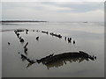
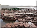
He said, "We found the first on January 19 2007, the day after storms had whipped up the sand revealing the bedrock below. The peat beds were formed from the floor of a vast forest, which once stretched right across the valley which now forms the Bristol Channel, until sea levels rose approximately 8,000 years ago."
The next day they found about 10 more footprints, going in both directions, along with smaller ones that could have been made by a child.
"The prints are deeply impressed into the surface, which illustrates their antiquity as the peat beds are now almost rock-hard, having been under tons of sand for the last 6,000 years.
Source: ICWales
The prints have been investigated and verified by Glamorgan-Gwent Archaeological Trust, they have reported it in their newsletter and produced two reports, here and here (PDF)
Steve announced the discovery in our forum at the time.
You may be viewing yesterday's version of this page. To see the most up to date information please register for a free account.
")
Do not use the above information on other web sites or publications without permission of the contributor.
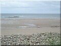
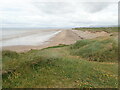
Nearby Images from Geograph Britain and Ireland:
©2007(licence)
©2014(licence)
©2021(licence)
©2021(licence)
©2021(licence)
The above images may not be of the site on this page, they are loaded from Geograph.
Please Submit an Image of this site or go out and take one for us!
Click here to see more info for this site
Nearby sites
Key: Red: member's photo, Blue: 3rd party photo, Yellow: other image, Green: no photo - please go there and take one, Grey: site destroyed
Download sites to:
KML (Google Earth)
GPX (GPS waypoints)
CSV (Garmin/Navman)
CSV (Excel)
To unlock full downloads you need to sign up as a Contributory Member. Otherwise downloads are limited to 50 sites.
Turn off the page maps and other distractions
Nearby sites listing. In the following links * = Image available
2.4km NE 36° Ffynnon Lygad Holy Well or Sacred Spring (SS79968261)
2.8km NE 56° Croes Y Ddadl Ancient Village or Settlement (SS80868222)
3.5km NNE 28° Tyn'r y selar* Standing Stone (Menhir) (SS80248374)
4.1km ENE 65° Pyle Slab Early Christian Sculptured Stone (SS82238232)
4.1km ESE 119° St David's Well (South Glamorgan)* Holy Well or Sacred Spring (SS8203578604)
4.5km SE 124° Ffynnon Fawr* Holy Well or Sacred Spring (SS82227808)
4.9km ESE 102° Mount Pleasant, Newton Nottage Round Cairn (SS83257960)
5.8km N 10° Margam Gorsedd Stone Circle* Modern Stone Circle etc (SS7961886387)
5.9km NNE 14° Margam Stones Museum* Museum (SS801864)
5.9km N 9° Ffynnon Pedr* Holy Well or Sacred Spring (SS79538654)
6.0km ENE 69° Pen-Y-Castell (Cynffig)* Ancient Village or Settlement (SS84228270)
6.1km ESE 122° St John's Well (Newton)* Holy Well or Sacred Spring (SS836773)
6.2km ESE 122° St John's Well (South Glamorgan)* Holy Well or Sacred Spring (SS8366877335)
6.2km NNE 12° Half Moon Camp Ancient Village or Settlement (SS79968673)
6.4km NNE 18° Mynydd y Castell* Hillfort (SS806867)
6.4km NNE 17° Lady's Well (South Glamorgan)* Holy Well or Sacred Spring (SS80478675)
6.5km NNE 15° Ffynnon Gyffyr* Holy Well or Sacred Spring (SS8030486920)
6.7km E 96° Mynydd Herbert* Round Barrow(s) (SS85137983)
6.8km E 83° Ty Du Stone or Scratching Post?* Standing Stone (Menhir) (SS85338133)
7.5km NNE 31° Ton-Mawr Hill Fort* Hillfort (SS825870)
7.5km ESE 118° Merthyr Mawr Warren 1 Cairn (SS850770)
7.7km N 3° Mynydd Brombil Ancient Village or Settlement (SS79048839)
8.0km N 5° Ergyd Isaf 1 Round Barrow(s) (SS79438864)
8.0km ESE 118° Merthyr Mawr Warren 2 Cairn (SS855768)
8.0km N 5° Ergyd Isaf 2 Round Barrow(s) (SS79458866)
View more nearby sites and additional images


 We would like to know more about this location. Please feel free to add a brief description and any relevant information in your own language.
 Wir möchten mehr über diese Stätte erfahren. Bitte zögern Sie nicht, eine kurze Beschreibung und relevante Informationen in Deutsch hinzuzufügen.
 Nous aimerions en savoir encore un peu sur les lieux. S'il vous plaît n'hesitez pas à ajouter une courte description et tous les renseignements pertinents dans votre propre langue.
 Quisieramos informarnos un poco más de las lugares. No dude en añadir una breve descripción y otros datos relevantes en su propio idioma.