<< Our Photo Pages >> Clach a' Phlaigh - Standing Stone (Menhir) in Scotland in Perth and Kinross
Submitted by BigSweetie on Friday, 26 March 2004 Page Views: 13276
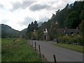
Neolithic and Bronze AgeSite Name: Clach a' Phlaigh Alternative Name: Carn na Marbh, Fortingall, Plague StoneCountry: Scotland County: Perth and Kinross Type: Standing Stone (Menhir)
Nearest Town: Kenmore Nearest Village: Fortingall
Map Ref: NN74064693 Landranger Map Number: 51
Latitude: 56.597301N Longitude: 4.052776W
Condition:
| 5 | Perfect |
| 4 | Almost Perfect |
| 3 | Reasonable but with some damage |
| 2 | Ruined but still recognisable as an ancient site |
| 1 | Pretty much destroyed, possibly visible as crop marks |
| 0 | No data. |
| -1 | Completely destroyed |
| 5 | Superb |
| 4 | Good |
| 3 | Ordinary |
| 2 | Not Good |
| 1 | Awful |
| 0 | No data. |
| 5 | Can be driven to, probably with disabled access |
| 4 | Short walk on a footpath |
| 3 | Requiring a bit more of a walk |
| 2 | A long walk |
| 1 | In the middle of nowhere, a nightmare to find |
| 0 | No data. |
| 5 | co-ordinates taken by GPS or official recorded co-ordinates |
| 4 | co-ordinates scaled from a detailed map |
| 3 | co-ordinates scaled from a bad map |
| 2 | co-ordinates of the nearest village |
| 1 | co-ordinates of the nearest town |
| 0 | no data |
Internal Links:
External Links:
I have visited· I would like to visit
Uralsdaughter visited on 18th Aug 2018 - their rating: Cond: 3 Amb: 4 Access: 4
Andy B have visited here
")
Standing stone (Carn na Marbh). The stone marks the mound under which victims of the 14th century Great Plague were buried. As such it is presumably not ancient, or at least disturbed from its original position.
You may be viewing yesterday's version of this page. To see the most up to date information please register for a free account.
")
")
")
")
Do not use the above information on other web sites or publications without permission of the contributor.
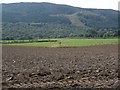
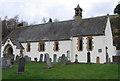
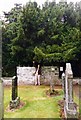
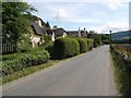
Nearby Images from Geograph Britain and Ireland:
©2011(licence)
©2006(licence)
©2010(licence)
©2011(licence)
©2009(licence)
The above images may not be of the site on this page, they are loaded from Geograph.
Please Submit an Image of this site or go out and take one for us!
Click here to see more info for this site
Nearby sites
Key: Red: member's photo, Blue: 3rd party photo, Yellow: other image, Green: no photo - please go there and take one, Grey: site destroyed
Download sites to:
KML (Google Earth)
GPX (GPS waypoints)
CSV (Garmin/Navman)
CSV (Excel)
To unlock full downloads you need to sign up as a Contributory Member. Otherwise downloads are limited to 50 sites.
Turn off the page maps and other distractions
Nearby sites listing. In the following links * = Image available
166m NE 55° Fortingall church crosses* Ancient Cross (NN74204702)
325m WNW 286° Fortingall Modern Stone Circle* Modern Stone Circle etc (NN73754703)
454m E 84° Fortingall SW* Stone Circle (NN7451446960)
476m E 83° Fortingall NE* Stone Circle (NN7453546977)
485m E 89° Fortingall S* Stone Circle (NN7454746927)
957m WSW 246° Lyon Bridge Cairn* Cairn (NN73174657)
1.1km WSW 239° Bridge of Lyon Standing Stones* Standing Stones (NN73144641)
1.2km WSW 249° Bridge of Lyon long cairn* Long Barrow (NN72964655)
2.3km SW 223° Cromrar 1* Rock Art (NN72474531)
2.5km SW 221° Cromrar 2* Rock Art (NN72344507)
2.7km SW 222° Cromrar 3 Rock Art (NN72184500)
2.7km SW 222° Fearnan Rock Art (NN72184497)
3.1km WNW 285° Coille Dhubh Standing Stones (NN711478)
3.1km SW 223° Clach-na-Cruich (Fearnan) Rock Art (NN7186844743)
3.2km SSW 212° Oakbank Crannog* Crannog (NN723443)
3.6km ESE 122° Scottish Crannog Centre* Museum (NN7704444910)
3.7km ESE 118° Spar Island* Crannog (NN773451)
4.5km SSE 152° Acharn Burn* Cairn (NN76074294)
4.5km E 85° An Tobar* Holy Well or Sacred Spring (NN786472)
4.6km SE 134° Balmacnaughton* Rock Art (NN7729043649)
4.6km E 90° Comrie Bridge Stone Circle (NN787468)
4.6km SSE 148° Queen's Wood (Acharn) Rock Art (NN76404291)
5.2km SSE 147° Acharn Falls* Stone Circle (NN7678742495)
5.2km E 91° Taymouth (1)* Standing Stones (NN793467)
5.3km ESE 108° Tombuie Cottage* Rock Art (NN791451)
View more nearby sites and additional images


 We would like to know more about this location. Please feel free to add a brief description and any relevant information in your own language.
 Wir möchten mehr über diese Stätte erfahren. Bitte zögern Sie nicht, eine kurze Beschreibung und relevante Informationen in Deutsch hinzuzufügen.
 Nous aimerions en savoir encore un peu sur les lieux. S'il vous plaît n'hesitez pas à ajouter une courte description et tous les renseignements pertinents dans votre propre langue.
 Quisieramos informarnos un poco más de las lugares. No dude en añadir una breve descripción y otros datos relevantes en su propio idioma.