<< Text Pages >> Achnagarron Stones - Standing Stones in Scotland in Highlands
Submitted by DavidHoyle on Tuesday, 24 January 2023 Page Views: 626
Neolithic and Bronze AgeSite Name: Achnagarron StonesCountry: Scotland
NOTE: This site is 1.979 km away from the location you searched for.
County: Highlands Type: Standing Stones
Nearest Town: Dornoch Nearest Village: Rogart
Map Ref: NC7329804978
Latitude: 58.015848N Longitude: 4.146309W
Condition:
| 5 | Perfect |
| 4 | Almost Perfect |
| 3 | Reasonable but with some damage |
| 2 | Ruined but still recognisable as an ancient site |
| 1 | Pretty much destroyed, possibly visible as crop marks |
| 0 | No data. |
| -1 | Completely destroyed |
| 5 | Superb |
| 4 | Good |
| 3 | Ordinary |
| 2 | Not Good |
| 1 | Awful |
| 0 | No data. |
| 5 | Can be driven to, probably with disabled access |
| 4 | Short walk on a footpath |
| 3 | Requiring a bit more of a walk |
| 2 | A long walk |
| 1 | In the middle of nowhere, a nightmare to find |
| 0 | No data. |
| 5 | co-ordinates taken by GPS or official recorded co-ordinates |
| 4 | co-ordinates scaled from a detailed map |
| 3 | co-ordinates scaled from a bad map |
| 2 | co-ordinates of the nearest village |
| 1 | co-ordinates of the nearest town |
| 0 | no data |
Be the first person to rate this site - see the 'Contribute!' box in the right hand menu.
Internal Links:
External Links:
Standing Stones in Highlands
Site from OS Map
58.0158449, -4.1463058
https://rogartheritage.co.uk/antiquities/achnagarron-stones-and-tumuli/
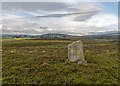
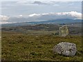
“Two standing stones, situated about 30m apart, and a spread of small cairns are situated on a heather-covered rise to the N of Achngarron. The ENE stone (NC 7329 0498, ROG95 921) stands 1.6m high, is 0.8m square at the base, with its faces presented to the cardinal points of the compass. It leans to the S and there are packing stones visible at the base of the stone. The WSW stone (NC 7327 0497, ROG95 922) is 1.3m in height, subrectangular in section, and measures 0.9m from N to S by 0.6m transversely. The small cairns extend for a distance of up to 140m from E to W by 60m transversely along the spine of the hill on which the standing stones are set.”
https://her.highland.gov.uk/Monument/MHG10614
Possibly remains of a Stone Circle.
https://goo.gl/maps/t2VDwQVy9UBjsLXF7
You may be viewing yesterday's version of this page. To see the most up to date information please register for a free account.
Do not use the above information on other web sites or publications without permission of the contributor.
Nearby Images from Geograph Britain and Ireland:
©2019(licence)

©2019(licence)
©2019(licence)

©2005(licence)
©2005(licence)
The above images may not be of the site on this page, they are loaded from Geograph.
Please Submit an Image of this site or go out and take one for us!
Click here to see more info for this site
Nearby sites
Key: Red: member's photo, Blue: 3rd party photo, Yellow: other image, Green: no photo - please go there and take one, Grey: site destroyed
Download sites to:
KML (Google Earth)
GPX (GPS waypoints)
CSV (Garmin/Navman)
CSV (Excel)
To unlock full downloads you need to sign up as a Contributory Member. Otherwise downloads are limited to 50 sites.
Turn off the page maps and other distractions
Nearby sites listing. In the following links * = Image available
5.2km N 353° Cnoc An Liath-Bhaid* Stone Circle (NC728102)
5.6km S 170° Carn Liath (Dornoch) Chambered Cairn (NH74119945)
5.7km NW 315° West Langwell Cairns Cairn (NC69410917)
5.8km NW 315° West Langwell Hut Circle Ancient Village or Settlement (NC69300921)
5.8km NW 315° Lang Well Holy Well or Sacred Spring (NC69300921)
5.9km NW 310° West Langwell Ancient Village or Settlement (NC68880888)
6.2km SSE 162° Thor's Tower Broch or Nuraghe (NH7599)
6.6km SSW 203° Strath Tollidh* Broch or Nuraghe (NH705990)
6.9km SSE 147° Aberscross* Stone Circle (NH7690399077)
8.0km NE 41° Coich Burn Broch or Nuraghe (NC78801087)
9.1km SE 132° St. Carden's Chapel Class I Pictish Symbol Stone (NH79939870)
10.2km ENE 60° Kilbraur Broch* Broch or Nuraghe (NC823098)
10.3km W 267° Allt Na Meirle Broch or Nuraghe (NC63000484)
10.4km ESE 101° Backies Broch* Broch or Nuraghe (NC83450261)
10.5km NE 35° Caisteal Na Coille* Broch or Nuraghe (NC79571337)
11.2km ENE 58° Ascoile Henge (NC83091058)
11.4km E 81° Carrol* Broch or Nuraghe (NC84620646)
11.6km SSE 153° Skelbo Wood Broch or Nuraghe (NH78209443)
12.4km ESE 107° Dunrobin Castle* Museum (NC85110103)
12.5km ESE 107° Craigton 1 Class I Pictish Symbol Stone (NC85130093)
13.6km ENE 77° Killin Broch* Broch or Nuraghe (NC867076)
14.2km ESE 103° Carn Liath (Sutherland)* Broch or Nuraghe (NC8703801376)
14.4km WNW 282° Saval Cairn Cairn (NC59220837)
15.0km W 268° River Shin SE Stone Circle (NC58220492)
15.0km W 268° Shin River* Stone Circle (NC582049)
View more nearby sites and additional images

")
 We would like to know more about this location. Please feel free to add a brief description and any relevant information in your own language.
 Wir möchten mehr über diese Stätte erfahren. Bitte zögern Sie nicht, eine kurze Beschreibung und relevante Informationen in Deutsch hinzuzufügen.
 Nous aimerions en savoir encore un peu sur les lieux. S'il vous plaît n'hesitez pas à ajouter une courte description et tous les renseignements pertinents dans votre propre langue.
 Quisieramos informarnos un poco más de las lugares. No dude en añadir una breve descripción y otros datos relevantes en su propio idioma.