<< Our Photo Pages >> Bridge of Lyon long cairn - Long Barrow in Scotland in Perth and Kinross
Submitted by rogerkread on Tuesday, 09 May 2017 Page Views: 1748
Neolithic and Bronze AgeSite Name: Bridge of Lyon long cairn Alternative Name: FortingallCountry: Scotland County: Perth and Kinross Type: Long Barrow
Nearest Town: Kenmore Nearest Village: Fortingall
Map Ref: NN72964655
Latitude: 56.593593N Longitude: 4.070492W
Condition:
| 5 | Perfect |
| 4 | Almost Perfect |
| 3 | Reasonable but with some damage |
| 2 | Ruined but still recognisable as an ancient site |
| 1 | Pretty much destroyed, possibly visible as crop marks |
| 0 | No data. |
| -1 | Completely destroyed |
| 5 | Superb |
| 4 | Good |
| 3 | Ordinary |
| 2 | Not Good |
| 1 | Awful |
| 0 | No data. |
| 5 | Can be driven to, probably with disabled access |
| 4 | Short walk on a footpath |
| 3 | Requiring a bit more of a walk |
| 2 | A long walk |
| 1 | In the middle of nowhere, a nightmare to find |
| 0 | No data. |
| 5 | co-ordinates taken by GPS or official recorded co-ordinates |
| 4 | co-ordinates scaled from a detailed map |
| 3 | co-ordinates scaled from a bad map |
| 2 | co-ordinates of the nearest village |
| 1 | co-ordinates of the nearest town |
| 0 | no data |
Internal Links:
External Links:
I have visited· I would like to visit
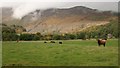
Uralsdaughter visited on 18th Aug 2018 - their rating: Cond: 3 Amb: 4 Access: 4 Field was full of curious cows.
")
A rather battered long cairn close to the road, easily reached with gates into the field near each end of the cairn. About 5 feet high and 100 feet long according to Canmore.
See the listing for Canmore ID 24999 Fortingall Long Cairn (Neolithic) which says adds: "NN 729 466: Possible Long Cairn, Fortingall. A mound of earth and stones measuring 105' along the ENE-WSW axis, and about 5' high. Across the E end it is about 30' wide, across the centre it is about 38', and about the same across the W end. In plan, the ends appear to be rounded. There is a very slight dip in the surface of the field along the S side of the mound which might indicate the presence of a ditch some 8' - 10' wide. On the N side, this feature, if it exists, is obscured by an old dyke running at an oblique angle to the side of the cairn."
You may be viewing yesterday's version of this page. To see the most up to date information please register for a free account.
")
Do not use the above information on other web sites or publications without permission of the contributor.
Nearby Images from Geograph Britain and Ireland:
©2018(licence)
©2017(licence)
©2007(licence)
©2010(licence)
©2012(licence)
The above images may not be of the site on this page, they are loaded from Geograph.
Please Submit an Image of this site or go out and take one for us!
Click here to see more info for this site
Nearby sites
Key: Red: member's photo, Blue: 3rd party photo, Yellow: other image, Green: no photo - please go there and take one, Grey: site destroyed
Download sites to:
KML (Google Earth)
GPX (GPS waypoints)
CSV (Garmin/Navman)
CSV (Excel)
To unlock full downloads you need to sign up as a Contributory Member. Otherwise downloads are limited to 50 sites.
Turn off the page maps and other distractions
Nearby sites listing. In the following links * = Image available
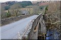
210m E 83° Lyon Bridge Cairn* Cairn (NN73174657)
227m SE 126° Bridge of Lyon Standing Stones* Standing Stones (NN73144641)
922m ENE 57° Fortingall Modern Stone Circle* Modern Stone Circle etc (NN73754703)
1.2km ENE 69° Clach a' Phlaigh* Standing Stone (Menhir) (NN74064693)
1.3km ENE 67° Fortingall church crosses* Ancient Cross (NN74204702)
1.3km SSW 200° Cromrar 1* Rock Art (NN72474531)
1.6km ENE 73° Fortingall SW* Stone Circle (NN7451446960)
1.6km SSW 201° Cromrar 2* Rock Art (NN72344507)
1.6km ENE 75° Fortingall S* Stone Circle (NN7454746927)
1.6km ENE 73° Fortingall NE* Stone Circle (NN7453546977)
1.7km SSW 205° Cromrar 3 Rock Art (NN72184500)
1.8km SSW 205° Fearnan Rock Art (NN72184497)
2.1km SSW 209° Clach-na-Cruich (Fearnan) Rock Art (NN7186844743)
2.2km WNW 302° Coille Dhubh Standing Stones (NN711478)
2.3km SSW 195° Oakbank Crannog* Crannog (NN723443)
4.4km ESE 110° Scottish Crannog Centre* Museum (NN7704444910)
4.6km ESE 107° Spar Island* Crannog (NN773451)
4.8km SE 138° Acharn Burn* Cairn (NN76074294)
5.0km SE 135° Queen's Wood (Acharn) Rock Art (NN76404291)
5.2km ESE 122° Balmacnaughton* Rock Art (NN7729043649)
5.5km SW 224° Allt Coire Phadairlidh 1* Rock Art (NN690427)
5.6km SE 135° Acharn Falls* Stone Circle (NN7678742495)
5.7km E 82° An Tobar* Holy Well or Sacred Spring (NN786472)
5.7km E 86° Comrie Bridge Stone Circle (NN787468)
6.3km ESE 102° Tombuie Cottage* Rock Art (NN791451)
View more nearby sites and additional images


 We would like to know more about this location. Please feel free to add a brief description and any relevant information in your own language.
 Wir möchten mehr über diese Stätte erfahren. Bitte zögern Sie nicht, eine kurze Beschreibung und relevante Informationen in Deutsch hinzuzufügen.
 Nous aimerions en savoir encore un peu sur les lieux. S'il vous plaît n'hesitez pas à ajouter une courte description et tous les renseignements pertinents dans votre propre langue.
 Quisieramos informarnos un poco más de las lugares. No dude en añadir una breve descripción y otros datos relevantes en su propio idioma.