<< Text Pages >> Loch Earn - Chambered Cairn in Scotland in Perth and Kinross
Submitted by Nick on Monday, 03 November 2003 Page Views: 9646
Neolithic and Bronze AgeSite Name: Loch Earn Alternative Name: KindrochetCountry: Scotland County: Perth and Kinross Type: Chambered Cairn
Nearest Town: Lochearnhead Nearest Village: St Fillians
Map Ref: NN723230 Landranger Map Number: 51
Latitude: 56.381980N Longitude: 4.069683W
Condition:
| 5 | Perfect |
| 4 | Almost Perfect |
| 3 | Reasonable but with some damage |
| 2 | Ruined but still recognisable as an ancient site |
| 1 | Pretty much destroyed, possibly visible as crop marks |
| 0 | No data. |
| -1 | Completely destroyed |
| 5 | Superb |
| 4 | Good |
| 3 | Ordinary |
| 2 | Not Good |
| 1 | Awful |
| 0 | No data. |
| 5 | Can be driven to, probably with disabled access |
| 4 | Short walk on a footpath |
| 3 | Requiring a bit more of a walk |
| 2 | A long walk |
| 1 | In the middle of nowhere, a nightmare to find |
| 0 | No data. |
| 5 | co-ordinates taken by GPS or official recorded co-ordinates |
| 4 | co-ordinates scaled from a detailed map |
| 3 | co-ordinates scaled from a bad map |
| 2 | co-ordinates of the nearest village |
| 1 | co-ordinates of the nearest town |
| 0 | no data |
Internal Links:
External Links:
I have visited· I would like to visit
MegalithicDania visited on 1st Jul 2013 - their rating: Cond: 4 Amb: 4 Access: 4
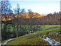
Off the A85 just before St Fillans, park beside the two cottages at Kindrochet (south side of the road), and ask at the second cottage - the man who lives there is very friendly (as are his dogs!) and will explain how to approach the chambered cairn if the bull is in a nearby field. Approaching from Dundurn farm is more difficult. Kindrochet Chambered Cairn is now in considerable disarray, but still well worth a look. Measuring around 130 feet by 30 feet, many of the internal features are still discernible even amongs the scatter of rubble and field clearance. The view to the west showed Dundurn hill clearly in the background, and it was easy to see why this site had been chosen. I took a number of photographs, but none of them really gives a great impression of this very peaceful place. Looking west along the length of the cairn gives a clear view of Dundurn hill fort. According to Canmore, it was excavated by Childe in 1929 and 1930, when it was found to be made of large water-worn boulders and to measure 135ft by a greatest width 36ft within a kerb embedded in virgin soil. Laid out with the long axis E and W, it contained three cists. The central cist contained a leaf-shaped arrowhead.
You may be viewing yesterday's version of this page. To see the most up to date information please register for a free account.
Do not use the above information on other web sites or publications without permission of the contributor.
Nearby Images from Geograph Britain and Ireland:

©2009(licence)

©2008(licence)
©2008(licence)

©2012(licence)

©2011(licence)
The above images may not be of the site on this page, they are loaded from Geograph.
Please Submit an Image of this site or go out and take one for us!
Click here to see more info for this site
Nearby sites
Key: Red: member's photo, Blue: 3rd party photo, Yellow: other image, Green: no photo - please go there and take one, Grey: site destroyed
Download sites to:
KML (Google Earth)
GPX (GPS waypoints)
CSV (Garmin/Navman)
CSV (Excel)
To unlock full downloads you need to sign up as a Contributory Member. Otherwise downloads are limited to 50 sites.
Turn off the page maps and other distractions
Nearby sites listing. In the following links * = Image available
223m NNW 332° Kindrochat Chambered Cairn (NN722232)
1.5km W 278° St Fillan's Chair (Dundurn) Natural Stone / Erratic / Other Natural Feature (NN70812325)
1.5km W 278° St Fillan's Well (Comrie) Holy Well or Sacred Spring (NN70802327)
1.7km E 88° Cluan-Glasdale Stone Circle (NN7423)
2.0km WNW 285° St Fillan's Chapel (Comrie)* Ancient Cross (NN7038323579)
2.3km WNW 299° Little Port* Standing Stone (Menhir) (NN70342415)
3.2km E 98° Tullybannocher* Stone Circle (NN75482247)
4.3km ESE 110° Craggish (Comrie) Standing Stones (NN763214)
4.5km ESE 113° Comrie Cursus Cursus (NN76422112)
4.6km ESE 118° Craggish Stone Row / Alignment (NN763207)
4.8km E 100° Tom na Chessaig Stone Circle (NN770220)
5.3km E 95° Coney Hill (Comrie)* Misc. Earthwork (NN77552238)
5.5km ESE 115° Comrie Cursus Cursus (NN77252048)
5.6km ESE 113° West Cowden* Stone Row / Alignment (NN7744520645)
5.7km ESE 115° Comrie Cursus Cursus (NN77422047)
6.0km ESE 105° Dalginross* Stone Circle (NN7802521264)
6.4km ENE 69° Balmuick* Stone Circle (NN78362513)
7.3km ESE 116° Auchingarrich Farm Standing Stone (Menhir) (NN78731958)
7.8km E 91° Lawers* Standing Stone (Menhir) (NN80102267)
8.2km SE 129° Giant's Knowe (Culloch) Cairn (NN78481762)
8.6km SE 125° Craigneich Farm* Standing Stone (Menhir) (NN7922617871)
8.9km E 87° Clathick House Standing Stone (Menhir) (NN81212315)
9.0km SE 129° Dunruchan C (Muthill)* Standing Stone (Menhir) (NN7910817137)
9.1km SE 131° Dunruchan D (Muthill)* Standing Stone (Menhir) (NN7904416881)
9.1km SE 131° Dunruchan E (Muthill)* Standing Stone (Menhir) (NN7899716819)
View more nearby sites and additional images


 We would like to know more about this location. Please feel free to add a brief description and any relevant information in your own language.
 Wir möchten mehr über diese Stätte erfahren. Bitte zögern Sie nicht, eine kurze Beschreibung und relevante Informationen in Deutsch hinzuzufügen.
 Nous aimerions en savoir encore un peu sur les lieux. S'il vous plaît n'hesitez pas à ajouter une courte description et tous les renseignements pertinents dans votre propre langue.
 Quisieramos informarnos un poco más de las lugares. No dude en añadir una breve descripción y otros datos relevantes en su propio idioma.