<< Our Photo Pages >> Kenric's Stone (Llanelltyd) - Early Christian Sculptured Stone in Wales in Gwynedd
Submitted by Sunny100 on Thursday, 18 May 2023 Page Views: 5813
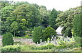
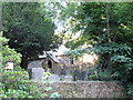
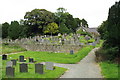
Early Medieval (Dark Age)Site Name: Kenric's Stone (Llanelltyd) Alternative Name: Cynwrig's Stone, Cenrick's StoneCountry: Wales County: Gwynedd Type: Early Christian Sculptured Stone
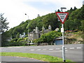
Nearest Town: Dolgellau Nearest Village: Llanelltyd
Map Ref: SH717195
Latitude: 52.757827N Longitude: 3.902632W
Condition:
| 5 | Perfect |
| 4 | Almost Perfect |
| 3 | Reasonable but with some damage |
| 2 | Ruined but still recognisable as an ancient site |
| 1 | Pretty much destroyed, possibly visible as crop marks |
| 0 | No data. |
| -1 | Completely destroyed |
| 5 | Superb |
| 4 | Good |
| 3 | Ordinary |
| 2 | Not Good |
| 1 | Awful |
| 0 | No data. |
| 5 | Can be driven to, probably with disabled access |
| 4 | Short walk on a footpath |
| 3 | Requiring a bit more of a walk |
| 2 | A long walk |
| 1 | In the middle of nowhere, a nightmare to find |
| 0 | No data. |
| 5 | co-ordinates taken by GPS or official recorded co-ordinates |
| 4 | co-ordinates scaled from a detailed map |
| 3 | co-ordinates scaled from a bad map |
| 2 | co-ordinates of the nearest village |
| 1 | co-ordinates of the nearest town |
| 0 | no data |
Internal Links:
External Links:
 (PID:258109)")
In the church a 4 foot high coffin-shaped stone stands near the altar, but its age is uncertain, probably 7th-11th century. Carved onto it is a footprint said to have been made by a pilgrim about to go overseas, whether to the Holy Land, Ireland or to Bardsey Island just across the bay. He may have had his footprint carved so as to guarantee a safe journey and a safe return.
A faint Latin inscription on the stone recalls VESTIGUM KENRIC TENETURE IN CAPITRE LAPIDID ET IPESEMET ANTEQUOM PEREGRE PRAFECTUS EST or when translated something like 'The footprint of Kenric imprinted at the head of this stone before he set out for foreign parts'. The stone was discovered under the floor of a small building in the churchyard in 1876.
You may be viewing yesterday's version of this page. To see the most up to date information please register for a free account.
 (PID:258110)")
Do not use the above information on other web sites or publications without permission of the contributor.
Nearby Images from Geograph Britain and Ireland:
©2007(licence)
©2007(licence)
©2008(licence)

©2024(licence)
©2007(licence)
The above images may not be of the site on this page, they are loaded from Geograph.
Please Submit an Image of this site or go out and take one for us!
Click here to see more info for this site
Nearby sites
Key: Red: member's photo, Blue: 3rd party photo, Yellow: other image, Green: no photo - please go there and take one, Grey: site destroyed
Download sites to:
KML (Google Earth)
GPX (GPS waypoints)
CSV (Garmin/Navman)
CSV (Excel)
To unlock full downloads you need to sign up as a Contributory Member. Otherwise downloads are limited to 50 sites.
Turn off the page maps and other distractions
Nearby sites listing. In the following links * = Image available
565m SE 134° Pentre Farm Barrow* Round Barrow(s) (SH721191)
988m NW 314° Tan Y Graig Cairn* Round Cairn (SH710202)
1.0km E 94° Coed Pen Y Bryn Defended Settlement* Hillfort (SH727194)
1.1km NW 306° Llyn Tan Y Graig Cairn* Cairn (SH708202)
1.2km NW 310° Cairn South of Mynydd Maes Mawr* Cairn (SH708203)
1.8km SSE 162° Pandy'r Odyn Well* Holy Well or Sacred Spring (SH722178)
1.8km SSE 149° Dolgellau* Modern Stone Circle etc (SH72581792)
1.8km ENE 59° Foel Faner* Hillfort (SH733204)
2.1km SSE 154° Ffynnon Fair (Dolgellau)* Holy Well or Sacred Spring (SH72601755)
2.5km N 5° Cefn Coch Cairn and Cist* Cairn (SH720220)
3.0km NNE 12° Tyddyn Bach Stone* Standing Stone (Menhir) (SH7241022420)
3.2km ENE 68° Caer Isaf Moel-Offrwm* Hillfort (SH747206)
3.3km N 1° Dolmelynllyn Estate Hut Circle* Ancient Village or Settlement (SH7187022823)
3.4km SSW 210° Waen Fechan Cairn 4* Cairn (SH699166)
3.4km SW 216° Waen Fechan Cairn 3* Cairn (SH696168)
3.5km SSE 155° Coed Croes Cairn* Cairn (SH731163)
3.5km SSW 213° Waen Fechan cairn 2* Cairn (SH69731660)
3.5km SW 215° Waen Fechan cairn 1* Cairn (SH69621666)
3.5km N 3° Dolmelynllyn Estate Platform House* Ancient Village or Settlement (SH7197223010)
3.5km ENE 63° Moel Offrwm* Hillfort (SH749210)
3.6km NNE 19° Carreg Coed Y Brenin* Modern Stone Circle etc (SH730229)
3.8km NE 48° Tyddyn Bach Round Barrow* Round Barrow(s) (SH74572196)
3.8km SW 214° Cairn North of Craig Y Castell.* Round Cairn (SH695164)
3.8km SSW 212° Craig Y Castell Stone Feature* Modern Stone Circle etc (SH696163)
4.1km N 4° Berth Llwyd Hut Circle* Ancient Village or Settlement (SH7210023550)
View more nearby sites and additional images


 We would like to know more about this location. Please feel free to add a brief description and any relevant information in your own language.
 Wir möchten mehr über diese Stätte erfahren. Bitte zögern Sie nicht, eine kurze Beschreibung und relevante Informationen in Deutsch hinzuzufügen.
 Nous aimerions en savoir encore un peu sur les lieux. S'il vous plaît n'hesitez pas à ajouter une courte description et tous les renseignements pertinents dans votre propre langue.
 Quisieramos informarnos un poco más de las lugares. No dude en añadir una breve descripción y otros datos relevantes en su propio idioma.