<< Our Photo Pages >> Pant y Griafolen - Ancient Village or Settlement in Wales in Conwy
Submitted by Postman on Wednesday, 03 October 2012 Page Views: 3218
Multi-periodSite Name: Pant y GriafolenCountry: Wales County: Conwy Type: Ancient Village or Settlement
Nearest Town: Bethesda
Map Ref: SH707665
Latitude: 53.179843N Longitude: 3.936228W
Condition:
| 5 | Perfect |
| 4 | Almost Perfect |
| 3 | Reasonable but with some damage |
| 2 | Ruined but still recognisable as an ancient site |
| 1 | Pretty much destroyed, possibly visible as crop marks |
| 0 | No data. |
| -1 | Completely destroyed |
| 5 | Superb |
| 4 | Good |
| 3 | Ordinary |
| 2 | Not Good |
| 1 | Awful |
| 0 | No data. |
| 5 | Can be driven to, probably with disabled access |
| 4 | Short walk on a footpath |
| 3 | Requiring a bit more of a walk |
| 2 | A long walk |
| 1 | In the middle of nowhere, a nightmare to find |
| 0 | No data. |
| 5 | co-ordinates taken by GPS or official recorded co-ordinates |
| 4 | co-ordinates scaled from a detailed map |
| 3 | co-ordinates scaled from a bad map |
| 2 | co-ordinates of the nearest village |
| 1 | co-ordinates of the nearest town |
| 0 | no data |
Internal Links:
External Links:
")
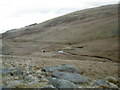
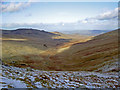
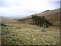
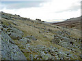
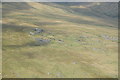
Tucked away in the mountains is this Bronze Age settlement. Beside the Afon Dulyn and not far from The twin lakes Mellynllyn and Dulyn reservoirs. Several still recognisable hut circles and some enclosure walls can be traced. The mountains loom large and brooding over this place, not a place for those of a nervous disposition.
You may be viewing yesterday's version of this page. To see the most up to date information please register for a free account.
")
")
")
")
Do not use the above information on other web sites or publications without permission of the contributor.
Nearby Images from Geograph Britain and Ireland:
©2008(licence)
©2008(licence)
©2005(licence)
©2008(licence)
©2013(licence)
The above images may not be of the site on this page, they are loaded from Geograph.
Please Submit an Image of this site or go out and take one for us!
Click here to see more info for this site
Nearby sites
Key: Red: member's photo, Blue: 3rd party photo, Yellow: other image, Green: no photo - please go there and take one, Grey: site destroyed
Download sites to:
KML (Google Earth)
GPX (GPS waypoints)
CSV (Garmin/Navman)
CSV (Excel)
To unlock full downloads you need to sign up as a Contributory Member. Otherwise downloads are limited to 50 sites.
Turn off the page maps and other distractions
Nearby sites listing. In the following links * = Image available
1.3km NNE 28° Afon Garreg Wen* Standing Stone (Menhir) (SH71336761)
1.8km ENE 77° Clogwyn-yr-Eryr* Stone Row / Alignment (SH72506687)
1.9km WSW 250° Foel Grach* Cairn (SH68886589)
2.8km NE 51° Ffrith-Y-Bont Stone Row* Stone Row / Alignment (SH72946819)
2.8km ENE 69° Hafodygors Wen* Ring Cairn (SH73366742)
3.1km N 1° Carnedd Penyborth Goch Cairn Cairn (SH70846959)
3.2km SW 227° Carnedd Llewelyn* Cairn (SH683644)
3.9km ENE 75° Waen Bryn-Gwenith* Burial Chamber or Dolmen (SH74476738)
4.1km N 358° Carnedd y Ddelw* Clava Cairn (SH707706)
4.3km SSE 166° Pen Llithrig Y Wrach* Cairn (SH71606232)
4.5km E 93° Cae Du* Cairn (SH75206616)
4.6km WNW 287° Drosgl* Cairn (SH663680)
4.7km NNW 341° Afon Anafon Arrow Stone* Sculptured Stone (SH69267098)
5.1km NE 55° Pen-y-Gaer (Conwy)* Hillfort (SH750693)
5.1km NNE 18° Cerrig Pryfaid* Stone Circle (SH72467133)
5.2km N 8° Barclodiad-y-Gawres (Conwy)* Cairn (SH716716)
5.2km N 8° Bwlch y Ddeufaen* Standing Stones (SH716716)
5.3km N 7° Bwlch y Ddeufaen S Standing Stone (Menhir) (SH7151071772)
5.4km N 7° Bwlch y Ddeufaen N Standing Stone (Menhir) (SH7145671828)
5.5km N 1° Llanerch Fedw* Cairn (SH709720)
5.5km NW 313° Coed Aber Roundhouse* Ancient Village or Settlement (SH6674570381)
5.6km SSE 168° Maen Trichwmwd Natural Stone / Erratic / Other Natural Feature (SH7169260962)
5.7km S 169° Bwlch Cowlyd Hut Circles* Ancient Village or Settlement (SH716609)
5.7km NW 319° Meuryn Isaf Cairn (SH671709)
5.7km S 180° Tal y Braich* Stone Circle (SH705608)
View more nearby sites and additional images


 We would like to know more about this location. Please feel free to add a brief description and any relevant information in your own language.
 Wir möchten mehr über diese Stätte erfahren. Bitte zögern Sie nicht, eine kurze Beschreibung und relevante Informationen in Deutsch hinzuzufügen.
 Nous aimerions en savoir encore un peu sur les lieux. S'il vous plaît n'hesitez pas à ajouter une courte description et tous les renseignements pertinents dans votre propre langue.
 Quisieramos informarnos un poco más de las lugares. No dude en añadir una breve descripción y otros datos relevantes en su propio idioma.