<< Our Photo Pages >> Giant's Dike - Hillfort in Scotland in Dumfries and Galloway
Submitted by markj99 on Friday, 18 February 2022 Page Views: 511
Iron Age and Later PrehistorySite Name: Giant's Dike Alternative Name: Barstobrick HillCountry: Scotland County: Dumfries and Galloway Type: Hillfort
Nearest Town: Castle Douglas Nearest Village: Ringford
Map Ref: NX68736065
Latitude: 54.923226N Longitude: 4.049811W
Condition:
| 5 | Perfect |
| 4 | Almost Perfect |
| 3 | Reasonable but with some damage |
| 2 | Ruined but still recognisable as an ancient site |
| 1 | Pretty much destroyed, possibly visible as crop marks |
| 0 | No data. |
| -1 | Completely destroyed |
| 5 | Superb |
| 4 | Good |
| 3 | Ordinary |
| 2 | Not Good |
| 1 | Awful |
| 0 | No data. |
| 5 | Can be driven to, probably with disabled access |
| 4 | Short walk on a footpath |
| 3 | Requiring a bit more of a walk |
| 2 | A long walk |
| 1 | In the middle of nowhere, a nightmare to find |
| 0 | No data. |
| 5 | co-ordinates taken by GPS or official recorded co-ordinates |
| 4 | co-ordinates scaled from a detailed map |
| 3 | co-ordinates scaled from a bad map |
| 2 | co-ordinates of the nearest village |
| 1 | co-ordinates of the nearest town |
| 0 | no data |
Internal Links:
External Links:
I have visited· I would like to visit
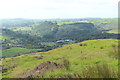
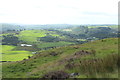
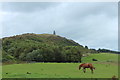
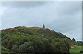
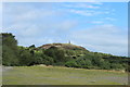
markj99 visited on 14th Feb 2022 - their rating: Cond: 2 Amb: 4 Access: 3 Giant's Dike Hillfort is easily visited from a trail leading N from Barstobrick Visitor centre. It is easily spotted by heading for the prominent Nielson's Monument on the summit of the hill. The path is muddy in places so stout footwear is advised.
")
Giant's Dike Hillfort consists of a ruined wall surrounding the upper slopes of Barstobrick Hill c. 1.75 miles N of Ringford in Dumfries and Galloway. According to Canmore ID 64189 there are remnants of the wall running from N to S on the hill, the E Flank relying on a steep craggy slope for natural defence. The internal area of the fort has no significant features beyond the modern addition of Nielson's Monument on the summit of Barstobrick Hill.
You may be viewing yesterday's version of this page. To see the most up to date information please register for a free account.
")
")
")
")
Do not use the above information on other web sites or publications without permission of the contributor.
Nearby Images from Geograph Britain and Ireland:
©2016(licence)
©2016(licence)
©2016(licence)
©2016(licence)
©2016(licence)
The above images may not be of the site on this page, they are loaded from Geograph.
Please Submit an Image of this site or go out and take one for us!
Click here to see more info for this site
Nearby sites
Key: Red: member's photo, Blue: 3rd party photo, Yellow: other image, Green: no photo - please go there and take one, Grey: site destroyed
Download sites to:
KML (Google Earth)
GPX (GPS waypoints)
CSV (Garmin/Navman)
CSV (Excel)
To unlock full downloads you need to sign up as a Contributory Member. Otherwise downloads are limited to 50 sites.
Turn off the page maps and other distractions
Nearby sites listing. In the following links * = Image available
2.6km WNW 286° Lairdmannoch* Stone Circle (NX66286143)
3.7km SSE 165° Holy Well (Parton) Holy Well or Sacred Spring (NX696570)
4.1km SSW 204° Fairies Well (Tongland) Holy Well or Sacred Spring (NX6695556911)
4.2km SSE 154° Park of Tongland Marked Stone Rock Art (NX70475685)
4.7km SSE 163° Park Of Tongland Stones* Standing Stones (NX69965609)
4.7km SE 136° St Ringan's Well (Kelton) Holy Well or Sacred Spring (NX71905713)
5.8km ENE 72° Little Wood Hill* Causewayed Enclosure (NX7433862318)
5.9km NW 316° Lochenbreck Well (Balmaghie) Holy Well or Sacred Spring (NX6479065025)
6.0km NW 307° Spa Well (Balmaghie) Holy Well or Sacred Spring (NX6400964416)
6.8km SSW 202° The Doon (Twynholm)* Hillfort (NX66035438)
7.1km ESE 106° Gelston White Cairn* Cairn (NX75555850)
7.3km ENE 61° Greenlaw Cairn (NX75186404)
7.3km SSW 201° Arden Fort* Hillfort (NX65875395)
7.3km S 172° Carse Moat* Hillfort (NX69555336)
7.8km SSW 199° Ingle Stone (Ingleston)* Natural Stone / Erratic / Other Natural Feature (NX6597753324)
8.4km SSE 164° Culdoach* Rock Art (NX70835250)
9.1km ENE 72° Ernespie* Stone Circle (NX77476321)
9.4km N 11° St Ninian's Well (Parton) Holy Well or Sacred Spring (NX7079369806)
9.6km WSW 248° Harper's Hill Standing Stone* Standing Stone (Menhir) (NX59735726)
9.6km S 180° Soaperie Gardens Well (Kirkcudbright)* Holy Well or Sacred Spring (NX6843251039)
9.8km S 182° Mercat Cross (Kirkcudbright)* Ancient Cross (NX6807650896)
9.8km S 181° Stewartry Museum* Museum (NX68335086)
9.9km S 178° Kirkcudbright Standing Stones* Standing Stones (NX6870450736)
10.3km ENE 60° St Michael's Well (Crossmichael) Holy Well or Sacred Spring (NX7783865566)
10.5km S 181° Butter Well (Kirkcudbright) Holy Well or Sacred Spring (NX6821250148)
View more nearby sites and additional images


 We would like to know more about this location. Please feel free to add a brief description and any relevant information in your own language.
 Wir möchten mehr über diese Stätte erfahren. Bitte zögern Sie nicht, eine kurze Beschreibung und relevante Informationen in Deutsch hinzuzufügen.
 Nous aimerions en savoir encore un peu sur les lieux. S'il vous plaît n'hesitez pas à ajouter une courte description et tous les renseignements pertinents dans votre propre langue.
 Quisieramos informarnos un poco más de las lugares. No dude en añadir una breve descripción y otros datos relevantes en su propio idioma.