<< Our Photo Pages >> Foel Ganol - Cairn in Wales in Conwy
Submitted by postman on Wednesday, 20 November 2013 Page Views: 3244
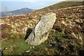
Neolithic and Bronze AgeSite Name: Foel GanolCountry: Wales County: Conwy Type: Cairn
Nearest Town: Llanfairfechan Nearest Village: Nant y Felin
Map Ref: SH68597221
Latitude: 53.230621N Longitude: 3.970133W
Condition:
| 5 | Perfect |
| 4 | Almost Perfect |
| 3 | Reasonable but with some damage |
| 2 | Ruined but still recognisable as an ancient site |
| 1 | Pretty much destroyed, possibly visible as crop marks |
| 0 | No data. |
| -1 | Completely destroyed |
| 5 | Superb |
| 4 | Good |
| 3 | Ordinary |
| 2 | Not Good |
| 1 | Awful |
| 0 | No data. |
| 5 | Can be driven to, probably with disabled access |
| 4 | Short walk on a footpath |
| 3 | Requiring a bit more of a walk |
| 2 | A long walk |
| 1 | In the middle of nowhere, a nightmare to find |
| 0 | No data. |
| 5 | co-ordinates taken by GPS or official recorded co-ordinates |
| 4 | co-ordinates scaled from a detailed map |
| 3 | co-ordinates scaled from a bad map |
| 2 | co-ordinates of the nearest village |
| 1 | co-ordinates of the nearest town |
| 0 | no data |
Internal Links:
External Links:
")
Coflein says this about the cairn
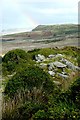
Cairn NNW of Foel Ganol at 1000ft above sea level. A circular mound of stones, 45ft in diameter and 3ft high on ground sloping to the N. Irregular hollows in the mound are probably the result of casual digging
Not far down the track from Foel Dduarth Arrow stone, and only ten minutes from the national wonder that is Carnedd y Saeson. In fact there are cairns, Arrow stones, possible standing stones, and habitation sites from many periods. This is a place heaving with history. Also there are the views across the Straits to Angelsey, and in the opposite direction the ground goes up and up, which is always nice.
You may be viewing yesterday's version of this page. To see the most up to date information please register for a free account.
")
")
")
")
Do not use the above information on other web sites or publications without permission of the contributor.
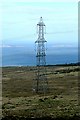
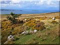
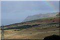
Nearby Images from Geograph Britain and Ireland:
©2009(licence)
©2013(licence)
©2009(licence)
©2009(licence)
©2011(licence)
The above images may not be of the site on this page, they are loaded from Geograph.
Please Submit an Image of this site or go out and take one for us!
Click here to see more info for this site
Nearby sites
Key: Red: member's photo, Blue: 3rd party photo, Yellow: other image, Green: no photo - please go there and take one, Grey: site destroyed
Download sites to:
KML (Google Earth)
GPX (GPS waypoints)
CSV (Garmin/Navman)
CSV (Excel)
To unlock full downloads you need to sign up as a Contributory Member. Otherwise downloads are limited to 50 sites.
Turn off the page maps and other distractions
Nearby sites listing. In the following links * = Image available
483m SW 230° Foel Dduarth (East)* Ancient Village or Settlement (SH68217191)
509m E 90° Carn yr Llechwedd* Cairn (SH691722)
596m WSW 251° Nant y Felin-fach Cairn* Cairn (SH68027203)
660m ENE 74° Ffridd Newydd Arrow stones* Rock Art (SH69237238)
753m SW 230° Foel Dduarth (Centre)* Ancient Village or Settlement (SH68007174)
813m E 82° Maen Ffordd Rufeinig* Standing Stone (Menhir) (SH694723)
889m WSW 236° Carnedd y Saeson* Cairn (SH6783471738)
960m W 259° Bod-Silin Cairns* Barrow Cemetery (SH67647205)
1.1km SW 234° Foel Dduarth (West)* Ancient Village or Settlement (SH67717161)
1.1km WSW 246° Wern-y-Pandy Settlement* Ancient Village or Settlement (SH676718)
1.2km NE 39° Garreg Fawr* Carving (SH6939373132)
1.3km WSW 244° Anafon Valley Cairns* Cairn (SH67397166)
1.4km SSE 150° Afon Anafon Arrow Stone* Sculptured Stone (SH69267098)
2.0km SW 227° Meuryn Isaf Cairn (SH671709)
2.1km NE 40° Dinas Settlement* Ancient Village or Settlement (SH700738)
2.3km W 276° Maes Y Gaer* Hillfort (SH663725)
2.3km E 94° Llanerch Fedw* Cairn (SH709720)
2.6km SW 224° Coed Aber Roundhouse* Ancient Village or Settlement (SH6674570381)
2.6km SE 126° Carnedd y Ddelw* Clava Cairn (SH707706)
2.9km E 96° Bwlch y Ddeufaen N Standing Stone (Menhir) (SH7145671828)
2.9km E 97° Bwlch y Ddeufaen S Standing Stone (Menhir) (SH7151071772)
3.1km E 100° Barclodiad-y-Gawres (Conwy)* Cairn (SH716716)
3.1km E 100° Bwlch y Ddeufaen* Standing Stones (SH716716)
3.4km SE 138° Carnedd Penyborth Goch Cairn Cairn (SH70846959)
3.5km WSW 246° Cras (Gwynedd)* Cairn (SH65397089)
View more nearby sites and additional images


 We would like to know more about this location. Please feel free to add a brief description and any relevant information in your own language.
 Wir möchten mehr über diese Stätte erfahren. Bitte zögern Sie nicht, eine kurze Beschreibung und relevante Informationen in Deutsch hinzuzufügen.
 Nous aimerions en savoir encore un peu sur les lieux. S'il vous plaît n'hesitez pas à ajouter une courte description et tous les renseignements pertinents dans votre propre langue.
 Quisieramos informarnos un poco más de las lugares. No dude en añadir una breve descripción y otros datos relevantes en su propio idioma.