<< Our Photo Pages >> Tomfat Plantation - Chambered Cairn in Scotland in Highlands
Submitted by Spindrift on Wednesday, 03 March 2004 Page Views: 7037
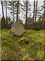
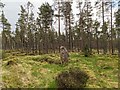
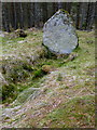
Neolithic and Bronze AgeSite Name: Tomfat PlantationCountry: Scotland County: Highlands Type: Chambered Cairn
Nearest Town: Inverness
Map Ref: NH678374 Landranger Map Number: 26
Latitude: 57.407702N Longitude: 4.202136W
Condition:
| 5 | Perfect |
| 4 | Almost Perfect |
| 3 | Reasonable but with some damage |
| 2 | Ruined but still recognisable as an ancient site |
| 1 | Pretty much destroyed, possibly visible as crop marks |
| 0 | No data. |
| -1 | Completely destroyed |
| 5 | Superb |
| 4 | Good |
| 3 | Ordinary |
| 2 | Not Good |
| 1 | Awful |
| 0 | No data. |
| 5 | Can be driven to, probably with disabled access |
| 4 | Short walk on a footpath |
| 3 | Requiring a bit more of a walk |
| 2 | A long walk |
| 1 | In the middle of nowhere, a nightmare to find |
| 0 | No data. |
| 5 | co-ordinates taken by GPS or official recorded co-ordinates |
| 4 | co-ordinates scaled from a detailed map |
| 3 | co-ordinates scaled from a bad map |
| 2 | co-ordinates of the nearest village |
| 1 | co-ordinates of the nearest town |
| 0 | no data |
Internal Links:
External Links:
I have visited· I would like to visit
SolarMegalith would like to visit
")
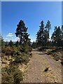
Park at the entrance car park for the forest. Take track immediately on the right after going through the gate. Follow this for approx 200 m then turn right onto another smaller track ( it goes over the low remains of an old wall). This track winds its way through the forest and eventually takes you right to the site.
You may be viewing yesterday's version of this page. To see the most up to date information please register for a free account.
")
")
")
Do not use the above information on other web sites or publications without permission of the contributor.
Nearby Images from Geograph Britain and Ireland:
©2020(licence)
©2020(licence)
©2008(licence)
©2023(licence)
©2022(licence)
The above images may not be of the site on this page, they are loaded from Geograph.
Please Submit an Image of this site or go out and take one for us!
Click here to see more info for this site
Nearby sites
Key: Red: member's photo, Blue: 3rd party photo, Yellow: other image, Green: no photo - please go there and take one, Grey: site destroyed
Download sites to:
KML (Google Earth)
GPX (GPS waypoints)
CSV (Garmin/Navman)
CSV (Excel)
To unlock full downloads you need to sign up as a Contributory Member. Otherwise downloads are limited to 50 sites.
Turn off the page maps and other distractions
Nearby sites listing. In the following links * = Image available
1.5km S 177° Gask Henge* Henge (NH67833590)
1.5km S 173° Gask Cairn* Ring Cairn (NH6794435860)
3.0km WNW 285° Essich Moor* Chambered Cairn (NH649383)
3.6km E 98° Midlairgs Stone Circle (NH714368)
3.8km S 177° Tordarroch cup-marked stone* Rock Art (NH679336)
3.9km S 175° Tordarroch Cairn* Clava Cairn (NH68013349)
4.2km S 171° Croftcroy Stone Circle* Stone Circle (NH6835133191)
4.3km S 172° Croftcroy Chambered Tomb Chambered Tomb (NH683331)
4.5km NW 309° Torbreck* Stone Circle (NH64384039)
4.6km N 7° Druidtemple* Stone Circle (NH685420)
5.8km WNW 284° Kinchyle Of Dores* Stone Circle (NH62153898)
6.1km SW 214° Eastertown Cairn* Cairn (NH64203245)
6.1km NE 51° Daviot Ring Cairn* Stone Circle (NH727411)
7.2km N 8° Essich House Class I Pictish Symbol Stone (NH69004456)
7.4km SW 228° West Town* Chambered Cairn (NH62173258)
7.5km N 354° Broad Stone Early Christian Sculptured Stone (NH672449)
7.6km NE 45° Forrest Cottage* Chambered Cairn (NH733426)
7.6km NNW 346° Knocknagael* Class I Pictish Symbol Stone (NH662448)
7.7km N 5° Raigmore* Clava Cairn (NH6878445083)
7.9km N 350° Inverness Museum* Museum (NH66684519)
7.9km N 350° Clach-na-Crudainn* Standing Stone (Menhir) (NH66684521)
7.9km N 7° Beechwood Farm Site Ancient Mine, Quarry or other Industry (NH6908045190)
7.9km WSW 257° Aldourie* Ring Cairn (NH59993587)
8.1km NW 315° Ladystone Farm* Stone Row / Alignment (NH62204330)
8.3km NW 323° Leachkin* Chambered Cairn (NH62964416)
View more nearby sites and additional images


 We would like to know more about this location. Please feel free to add a brief description and any relevant information in your own language.
 Wir möchten mehr über diese Stätte erfahren. Bitte zögern Sie nicht, eine kurze Beschreibung und relevante Informationen in Deutsch hinzuzufügen.
 Nous aimerions en savoir encore un peu sur les lieux. S'il vous plaît n'hesitez pas à ajouter une courte description et tous les renseignements pertinents dans votre propre langue.
 Quisieramos informarnos un poco más de las lugares. No dude en añadir una breve descripción y otros datos relevantes en su propio idioma.