


<< Our Photo Pages >> Gask Henge - Henge in Scotland in Highlands
Submitted by mattchapman on Tuesday, 17 May 2016 Page Views: 2592
Neolithic and Bronze AgeSite Name: Gask HengeCountry: Scotland County: Highlands Type: Henge
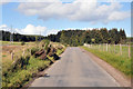
Nearest Town: Inverness Nearest Village: Balnafoich.
Map Ref: NH67833590
Latitude: 57.394247N Longitude: 4.20083W
Condition:
| 5 | Perfect |
| 4 | Almost Perfect |
| 3 | Reasonable but with some damage |
| 2 | Ruined but still recognisable as an ancient site |
| 1 | Pretty much destroyed, possibly visible as crop marks |
| 0 | No data. |
| -1 | Completely destroyed |
| 5 | Superb |
| 4 | Good |
| 3 | Ordinary |
| 2 | Not Good |
| 1 | Awful |
| 0 | No data. |
| 5 | Can be driven to, probably with disabled access |
| 4 | Short walk on a footpath |
| 3 | Requiring a bit more of a walk |
| 2 | A long walk |
| 1 | In the middle of nowhere, a nightmare to find |
| 0 | No data. |
| 5 | co-ordinates taken by GPS or official recorded co-ordinates |
| 4 | co-ordinates scaled from a detailed map |
| 3 | co-ordinates scaled from a bad map |
| 2 | co-ordinates of the nearest village |
| 1 | co-ordinates of the nearest town |
| 0 | no data |
Be the first person to rate this site - see the 'Contribute!' box in the right hand menu.
Internal Links:
External Links:
")
Canmore report below.
Henge (possible)
Site Name Gask
Classification Henge (possible)
Canmore ID 305331
Site Number NH63NE 93
NGR NH 6783 3590
Datum OSGB36 - NGR
Permalink http://canmore.org.uk/site/305331
Ordnance Survey licence number 100057073. All rights reserved.
© Copyright and database right 2016.
View on large map
Correction Favourite
Administrative Areas
Council Highland Parish Daviot And Dunlichity Former Region Highland Former District Inverness Former County Inverness-shire
Activities
Field Visit (2009)
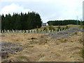
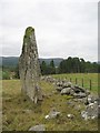
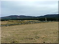
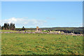
NH 6783 3590 A possible unrecorded henge was noticed during a visit to the fallen standing stone (HHER MHG 32689) near the Clava ring cairn at Gask (NH63NE 10). Just under half of a substantial circular structure with an external bank and internal ditch can be seen projecting from under the modern road (B861) on the opposite side from the ring cairn. This area was until recently under modern pine plantation. There are tree stumps emerging from the bank and a large quantity of brashing has been left lying over parts of it.
The bank and ditch are both c2.5m wide and the ditch reaches a maximum depth of c1.1m. The bank remains are slightly higher than the current road while the central area is slightly below it. The width of the site measured along the roadside is 22m, making the site originally c25m in diameter and placing the centre of the site roughly in the middle of the road.
Projecting the line of the bank by eye suggests that the possible standing stone could have stood on the bank or just outside it (possibly near an entrance?). This might imply that the present road line may be the result of earlier traffic passing through the henge using entrances on a roughly N–S axis. Both the bank and central area have visible stones. Some of those on the bank are quite large and could perhaps be monoliths.
It has been suggested (D Scott, pers comm) that from the Gask ring cairn the fallen standing stone would indicate the setting position of the sun at the summer quarter days (early May and August). From the estimated centre of the henge this stone would also indicate the rising position of the sun at mid-summer, and the largest monolith at the ring cairn would indicate the winter quarter day’s sunrise (early February and November).
Archive: D Trevarthen
David Trevarthen
Further Details
References
Trevarthen, D. (2009a) Gask 'henge', Highland (Daviot and Dunlichity parish), field visit', Discovery Excav Scot, New, vol. 10, 2009. Cathedral Communications Limited, Wiltshire, England. Page(s): 96
You may be viewing yesterday's version of this page. To see the most up to date information please register for a free account.
")
")
")
Do not use the above information on other web sites or publications without permission of the contributor.
Nearby Images from Geograph Britain and Ireland:
©2010(licence)
©2010(licence)
©2006(licence)
©2010(licence)
©2010(licence)
The above images may not be of the site on this page, they are loaded from Geograph.
Please Submit an Image of this site or go out and take one for us!
Click here to see more info for this site
Nearby sites
Key: Red: member's photo, Blue: 3rd party photo, Yellow: other image, Green: no photo - please go there and take one, Grey: site destroyed
Download sites to:
KML (Google Earth)
GPX (GPS waypoints)
CSV (Garmin/Navman)
CSV (Excel)
To unlock full downloads you need to sign up as a Contributory Member. Otherwise downloads are limited to 50 sites.
Turn off the page maps and other distractions
Nearby sites listing. In the following links * = Image available
120m ESE 108° Gask Cairn* Ring Cairn (NH6794435860)
1.5km N 357° Tomfat Plantation* Chambered Cairn (NH678374)
2.3km S 176° Tordarroch cup-marked stone* Rock Art (NH679336)
2.4km S 174° Tordarroch Cairn* Clava Cairn (NH68013349)
2.8km SSE 167° Croftcroy Stone Circle* Stone Circle (NH6835133191)
2.8km SSE 169° Croftcroy Chambered Tomb Chambered Tomb (NH683331)
3.7km ENE 74° Midlairgs Stone Circle (NH714368)
3.8km NW 308° Essich Moor* Chambered Cairn (NH649383)
5.0km SW 225° Eastertown Cairn* Cairn (NH64203245)
5.7km NW 321° Torbreck* Stone Circle (NH64384039)
6.1km N 4° Druidtemple* Stone Circle (NH685420)
6.4km WNW 297° Kinchyle Of Dores* Stone Circle (NH62153898)
6.5km WSW 238° West Town* Chambered Cairn (NH62173258)
7.1km NE 41° Daviot Ring Cairn* Stone Circle (NH727411)
7.8km W 268° Aldourie* Ring Cairn (NH59993587)
8.6km NE 37° Forrest Cottage* Chambered Cairn (NH733426)
8.7km N 6° Essich House Class I Pictish Symbol Stone (NH69004456)
9.0km N 354° Broad Stone Early Christian Sculptured Stone (NH672449)
9.0km NNW 348° Knocknagael* Class I Pictish Symbol Stone (NH662448)
9.2km N 4° Raigmore* Clava Cairn (NH6878445083)
9.3km NW 321° Ladystone Farm* Stone Row / Alignment (NH62204330)
9.3km N 351° Inverness Museum* Museum (NH66684519)
9.4km N 6° Beechwood Farm Site Ancient Mine, Quarry or other Industry (NH6908045190)
9.4km N 351° Clach-na-Crudainn* Standing Stone (Menhir) (NH66684521)
9.6km NNW 328° Leachkin* Chambered Cairn (NH62964416)
View more nearby sites and additional images


 We would like to know more about this location. Please feel free to add a brief description and any relevant information in your own language.
 Wir möchten mehr über diese Stätte erfahren. Bitte zögern Sie nicht, eine kurze Beschreibung und relevante Informationen in Deutsch hinzuzufügen.
 Nous aimerions en savoir encore un peu sur les lieux. S'il vous plaît n'hesitez pas à ajouter une courte description et tous les renseignements pertinents dans votre propre langue.
 Quisieramos informarnos un poco más de las lugares. No dude en añadir una breve descripción y otros datos relevantes en su propio idioma.