<< Our Photo Pages >> Carn Liath, Alness - Cairn in Scotland in Highlands
Submitted by markj99 on Wednesday, 23 September 2020 Page Views: 917
Neolithic and Bronze AgeSite Name: Carn Liath, Alness Alternative Name: DalmoreCountry: Scotland County: Highlands Type: Cairn
Nearest Town: Alness
Map Ref: NH66626952
Latitude: 57.695654N Longitude: 4.23939W
Condition:
| 5 | Perfect |
| 4 | Almost Perfect |
| 3 | Reasonable but with some damage |
| 2 | Ruined but still recognisable as an ancient site |
| 1 | Pretty much destroyed, possibly visible as crop marks |
| 0 | No data. |
| -1 | Completely destroyed |
| 5 | Superb |
| 4 | Good |
| 3 | Ordinary |
| 2 | Not Good |
| 1 | Awful |
| 0 | No data. |
| 5 | Can be driven to, probably with disabled access |
| 4 | Short walk on a footpath |
| 3 | Requiring a bit more of a walk |
| 2 | A long walk |
| 1 | In the middle of nowhere, a nightmare to find |
| 0 | No data. |
| 5 | co-ordinates taken by GPS or official recorded co-ordinates |
| 4 | co-ordinates scaled from a detailed map |
| 3 | co-ordinates scaled from a bad map |
| 2 | co-ordinates of the nearest village |
| 1 | co-ordinates of the nearest town |
| 0 | no data |
Internal Links:
External Links:
")
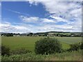
Many antiquarians will have driven past this cairn, sited in a field E of Alness on the A9. I saw what I imagined to be a cairn surrounded by a ring of trees. Just for once I was correct.
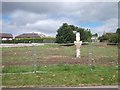
Canmore ID 13615 confirms the existence of a 60 ft cairn which was removed about 1810. A substantial capstone was left covering a 3.5 x 2.5 x 2 foot cist.
A circular stone wall was built inside the cairn boundary and trees were planted round the levelled interior.
These trees have grown tall but the level grassy interior and central cist and capstone are still preserved. Somehow, for me, the ring of mature trees round the naked cist give this site a sacred aspect.
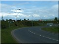
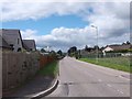
Directions: Turn off the A9 to Alness, turn L along Obsdale Road, turn L into Kendall Crescent then L again into Salvesson Crescent. The cairn lies within 150 yards E of this location.
You may be viewing yesterday's version of this page. To see the most up to date information please register for a free account.
")
")
")
Do not use the above information on other web sites or publications without permission of the contributor.
Nearby Images from Geograph Britain and Ireland:
©2005(licence)
©2023(licence)
©2015(licence)
©2015(licence)
©2022(licence)
The above images may not be of the site on this page, they are loaded from Geograph.
Please Submit an Image of this site or go out and take one for us!
Click here to see more info for this site
Nearby sites
Key: Red: member's photo, Blue: 3rd party photo, Yellow: other image, Green: no photo - please go there and take one, Grey: site destroyed
Download sites to:
KML (Google Earth)
GPX (GPS waypoints)
CSV (Garmin/Navman)
CSV (Excel)
To unlock full downloads you need to sign up as a Contributory Member. Otherwise downloads are limited to 50 sites.
Turn off the page maps and other distractions
Nearby sites listing. In the following links * = Image available
1.6km ESE 107° Rosskeen* Class I Pictish Symbol Stone (NH6809969024)
1.7km NNW 329° Mill craig Chambered Tomb (NH658710)
1.8km NNW 345° Nonakiln Class I Pictish Symbol Stone (NH66217124)
2.9km NNW 337° Cnoc Navie Chambered Cairn (NH656722)
4.5km NNE 20° Newmore Wood Rock Art (NH68327366)
4.8km NNW 343° Stittenham Cairn 2 Cairn (NH65367413)
5.0km NNW 336° Dalnavie Class I Pictish Symbol Stone (NH64737414)
5.0km NNW 339° The Ardross Wolf Class I Pictish Stone* Class I Pictish Symbol Stone (NH650743)
5.1km NNW 338° Stittenham Cairn 1 Chambered Tomb (NH649743)
5.8km NW 326° Carn Nam Fiann Chambered Cairn (NH63517441)
6.4km NNE 27° King's Head Cairn Chambered Cairn (NH69777513)
6.7km NNE 28° Kinrive West Chambered Cairn (NH69937538)
6.7km S 183° Mid Brae Chambered Cairn (NH661628)
7.2km NNW 331° Baldoon Chambered Cairn (NH63317591)
7.3km NW 313° Carn Na Feinne Chambered Cairn (NH615747)
7.3km SSW 195° St Martin's Well (Fortrose)* Holy Well or Sacred Spring (NH645625)
8.2km S 185° Wester Brae* Chambered Cairn (NH65646139)
8.2km NE 34° Scotsburn House Dun* Stone Fort or Dun (NH71487616)
8.3km NE 34° Scotsburn House Chambered Cairn Chambered Cairn (NH71537618)
8.3km WSW 247° Carn Liath (Upper Park) Chambered Cairn (NH589665)
8.7km S 189° Woodhead Round Chambered Cairn* Chambered Cairn (NH650610)
8.9km S 187° Woodhead Long* Chambered Cairn (NH653607)
9.0km NE 35° Scotsburn Wood West Chambered Tomb (NH721767)
9.3km WSW 247° Swordale Chambered Cairn Chambered Cairn (NH57886614)
9.4km WNW 296° Boath Short Chambered Cairn (NH58337395)
View more nearby sites and additional images


 We would like to know more about this location. Please feel free to add a brief description and any relevant information in your own language.
 Wir möchten mehr über diese Stätte erfahren. Bitte zögern Sie nicht, eine kurze Beschreibung und relevante Informationen in Deutsch hinzuzufügen.
 Nous aimerions en savoir encore un peu sur les lieux. S'il vous plaît n'hesitez pas à ajouter une courte description et tous les renseignements pertinents dans votre propre langue.
 Quisieramos informarnos un poco más de las lugares. No dude en añadir una breve descripción y otros datos relevantes en su propio idioma.