


<< Our Photo Pages >> Cairn N of Moel Wnion - Cairn in Wales in Gwynedd
Submitted by Postman on Saturday, 06 October 2012 Page Views: 2649
Neolithic and Bronze AgeSite Name: Cairn N of Moel WnionCountry: Wales County: Gwynedd Type: Cairn
Nearest Town: Bethesda
Map Ref: SH65197071
Latitude: 53.216294N Longitude: 4.0204W
Condition:
| 5 | Perfect |
| 4 | Almost Perfect |
| 3 | Reasonable but with some damage |
| 2 | Ruined but still recognisable as an ancient site |
| 1 | Pretty much destroyed, possibly visible as crop marks |
| 0 | No data. |
| -1 | Completely destroyed |
| 5 | Superb |
| 4 | Good |
| 3 | Ordinary |
| 2 | Not Good |
| 1 | Awful |
| 0 | No data. |
| 5 | Can be driven to, probably with disabled access |
| 4 | Short walk on a footpath |
| 3 | Requiring a bit more of a walk |
| 2 | A long walk |
| 1 | In the middle of nowhere, a nightmare to find |
| 0 | No data. |
| 5 | co-ordinates taken by GPS or official recorded co-ordinates |
| 4 | co-ordinates scaled from a detailed map |
| 3 | co-ordinates scaled from a bad map |
| 2 | co-ordinates of the nearest village |
| 1 | co-ordinates of the nearest town |
| 0 | no data |
Internal Links:
External Links:
")
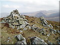
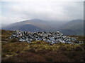
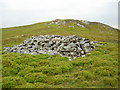
There are two cairns just below the summit of Moel Wnion, Cras is one and this one is the other, Coflein have named it "Cairn north of Moel Wnion". When Coflein was at school I bet it's teacher was always saying you must try harder. But they got the discription bang on. It has been badly mutilated by farmers past, who made it into sheep shelters, it is therefore a testament to its bronze age builders, because theres at least four sheep pens in the cairn. But they couldn't hide the fact that this is a large and very old pile of stones. I wonder if Like at Cras there could be another cist/chamber in the middle under all that stone?
You may be viewing yesterday's version of this page. To see the most up to date information please register for a free account.
")
")
Do not use the above information on other web sites or publications without permission of the contributor.
Nearby Images from Geograph Britain and Ireland:

©2013(licence)
©2021(licence)
©2008(licence)
©2021(licence)
©2008(licence)
The above images may not be of the site on this page, they are loaded from Geograph.
Please Submit an Image of this site or go out and take one for us!
Click here to see more info for this site
Nearby sites
Key: Red: member's photo, Blue: 3rd party photo, Yellow: other image, Green: no photo - please go there and take one, Grey: site destroyed
Download sites to:
KML (Google Earth)
GPX (GPS waypoints)
CSV (Garmin/Navman)
CSV (Excel)
To unlock full downloads you need to sign up as a Contributory Member. Otherwise downloads are limited to 50 sites.
Turn off the page maps and other distractions
Nearby sites listing. In the following links * = Image available
269m NE 46° Cras (Gwynedd)* Cairn (SH65397089)
1.0km SSW 191° Moel Wnion (Gwynedd)* Cairn (SH64966971)
1.6km E 100° Coed Aber Roundhouse* Ancient Village or Settlement (SH6674570381)
1.9km E 83° Meuryn Isaf Cairn (SH671709)
2.1km NNE 30° Maes Y Gaer* Hillfort (SH663725)
2.2km SSW 208° Hut Circle at Twll Pant Hiriol* Ancient Village or Settlement (SH641688)
2.4km ENE 65° Anafon Valley Cairns* Cairn (SH67397166)
2.6km ENE 64° Wern-y-Pandy Settlement* Ancient Village or Settlement (SH676718)
2.7km ENE 69° Foel Dduarth (West)* Ancient Village or Settlement (SH67717161)
2.8km SSW 210° Bwlch ym Mhwll-le* Cairn (SH63746835)
2.8km ENE 60° Bod-Silin Cairns* Barrow Cemetery (SH67647205)
2.8km ENE 67° Carnedd y Saeson* Cairn (SH6783471738)
2.9km SSE 156° Drosgl* Cairn (SH663680)
3.0km ENE 68° Foel Dduarth (Centre)* Ancient Village or Settlement (SH68007174)
3.1km SSW 212° Moel Faban* Cairn (SH63486811)
3.1km ENE 63° Nant y Felin-fach Cairn* Cairn (SH68027203)
3.2km ENE 67° Foel Dduarth (East)* Ancient Village or Settlement (SH68217191)
3.3km SSW 207° Moel Faban Arrow Stone* Carving (SH63576780)
3.5km SW 214° Cairn cemetery, W. shoulder of Moel Faban* Cairn (SH63156789)
3.7km SW 218° Fortified hut settlement above Rachub* Hillfort (SH62826790)
3.7km ENE 65° Foel Ganol* Cairn (SH68597221)
3.8km WSW 247° Rhiw Goch Enclosed Hut Circle Settlement* Ancient Village or Settlement (SH61696931)
4.1km E 85° Afon Anafon Arrow Stone* Sculptured Stone (SH69267098)
4.2km SW 228° Maes Bleddyn Hut Circle Settlement* Ancient Village or Settlement (SH6200768009)
4.2km ENE 67° Carn yr Llechwedd* Cairn (SH691722)
View more nearby sites and additional images


 We would like to know more about this location. Please feel free to add a brief description and any relevant information in your own language.
 Wir möchten mehr über diese Stätte erfahren. Bitte zögern Sie nicht, eine kurze Beschreibung und relevante Informationen in Deutsch hinzuzufügen.
 Nous aimerions en savoir encore un peu sur les lieux. S'il vous plaît n'hesitez pas à ajouter une courte description et tous les renseignements pertinents dans votre propre langue.
 Quisieramos informarnos un poco más de las lugares. No dude en añadir una breve descripción y otros datos relevantes en su propio idioma.