<< Our Photo Pages >> Moel Wnion (Gwynedd) - Cairn in Wales in Gwynedd
Submitted by Postman on Saturday, 06 October 2012 Page Views: 3085
Neolithic and Bronze AgeSite Name: Moel Wnion (Gwynedd)Country: Wales County: Gwynedd Type: Cairn
Map Ref: SH64966971
Latitude: 53.207252N Longitude: 4.023419W
Condition:
| 5 | Perfect |
| 4 | Almost Perfect |
| 3 | Reasonable but with some damage |
| 2 | Ruined but still recognisable as an ancient site |
| 1 | Pretty much destroyed, possibly visible as crop marks |
| 0 | No data. |
| -1 | Completely destroyed |
| 5 | Superb |
| 4 | Good |
| 3 | Ordinary |
| 2 | Not Good |
| 1 | Awful |
| 0 | No data. |
| 5 | Can be driven to, probably with disabled access |
| 4 | Short walk on a footpath |
| 3 | Requiring a bit more of a walk |
| 2 | A long walk |
| 1 | In the middle of nowhere, a nightmare to find |
| 0 | No data. |
| 5 | co-ordinates taken by GPS or official recorded co-ordinates |
| 4 | co-ordinates scaled from a detailed map |
| 3 | co-ordinates scaled from a bad map |
| 2 | co-ordinates of the nearest village |
| 1 | co-ordinates of the nearest town |
| 0 | no data |
Internal Links:
External Links:
 (PID:95415)")
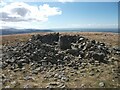
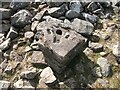
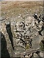
Five hundred and eighty meters up in the air is the cairn on Moel Wnion. Sadly the ordnance survey planted their part time trig point in the middle of it, a large concrete block still occupies the cairns interior. I suppose the walking wallies have had a hand in its present state as well.
There should have been epic views all round, but alas the clouds closed in and reduced the views to about twenty yards. A visit should be combined with Cras and it's very near neighbour, for most rewards go in good weather!
You may be viewing yesterday's version of this page. To see the most up to date information please register for a free account.
 (PID:95416)")
Do not use the above information on other web sites or publications without permission of the contributor.
Nearby Images from Geograph Britain and Ireland:

©2011(licence)

©2021(licence)
©2020(licence)
©2020(licence)
©2020(licence)
The above images may not be of the site on this page, they are loaded from Geograph.
Please Submit an Image of this site or go out and take one for us!
Click here to see more info for this site
Nearby sites
Key: Red: member's photo, Blue: 3rd party photo, Yellow: other image, Green: no photo - please go there and take one, Grey: site destroyed
Download sites to:
KML (Google Earth)
GPX (GPS waypoints)
CSV (Garmin/Navman)
CSV (Excel)
To unlock full downloads you need to sign up as a Contributory Member. Otherwise downloads are limited to 50 sites.
Turn off the page maps and other distractions
Nearby sites listing. In the following links * = Image available
1.0km NNE 11° Cairn N of Moel Wnion* Cairn (SH65197071)
1.2km SW 222° Hut Circle at Twll Pant Hiriol* Ancient Village or Settlement (SH641688)
1.3km NNE 18° Cras (Gwynedd)* Cairn (SH65397089)
1.8km SW 220° Bwlch ym Mhwll-le* Cairn (SH63746835)
1.9km ENE 68° Coed Aber Roundhouse* Ancient Village or Settlement (SH6674570381)
2.2km SE 140° Drosgl* Cairn (SH663680)
2.2km SW 221° Moel Faban* Cairn (SH63486811)
2.4km SW 214° Moel Faban Arrow Stone* Carving (SH63576780)
2.4km ENE 59° Meuryn Isaf Cairn (SH671709)
2.6km SW 223° Cairn cemetery, W. shoulder of Moel Faban* Cairn (SH63156789)
2.8km SW 228° Fortified hut settlement above Rachub* Hillfort (SH62826790)
3.1km NNE 24° Maes Y Gaer* Hillfort (SH663725)
3.1km NE 50° Anafon Valley Cairns* Cairn (SH67397166)
3.3km SW 219° Pen Y Gaer (Bethesda)* Hillfort (SH62826725)
3.3km SW 219° Pen y Gaer* Hillfort (SH62826725)
3.3km W 261° Rhiw Goch Enclosed Hut Circle Settlement* Ancient Village or Settlement (SH61696931)
3.3km NE 54° Foel Dduarth (West)* Ancient Village or Settlement (SH67717161)
3.4km NE 50° Wern-y-Pandy Settlement* Ancient Village or Settlement (SH676718)
3.4km WSW 238° Maes Bleddyn Hut Circle Settlement* Ancient Village or Settlement (SH6200768009)
3.5km NE 53° Carnedd y Saeson* Cairn (SH6783471738)
3.6km NE 47° Bod-Silin Cairns* Barrow Cemetery (SH67647205)
3.6km NE 55° Foel Dduarth (Centre)* Ancient Village or Settlement (SH68007174)
3.8km NE 51° Nant y Felin-fach Cairn* Cairn (SH68027203)
3.9km NE 54° Foel Dduarth (East)* Ancient Village or Settlement (SH68217191)
4.4km NE 54° Foel Ganol* Cairn (SH68597221)
View more nearby sites and additional images


 We would like to know more about this location. Please feel free to add a brief description and any relevant information in your own language.
 Wir möchten mehr über diese Stätte erfahren. Bitte zögern Sie nicht, eine kurze Beschreibung und relevante Informationen in Deutsch hinzuzufügen.
 Nous aimerions en savoir encore un peu sur les lieux. S'il vous plaît n'hesitez pas à ajouter une courte description et tous les renseignements pertinents dans votre propre langue.
 Quisieramos informarnos un poco más de las lugares. No dude en añadir una breve descripción y otros datos relevantes en su propio idioma.