<< Our Photo Pages >> Ffridd Fron Kerb Cairn and Cist - Cairn in Wales in Gwynedd
Submitted by TAlanJones on Monday, 21 March 2022 Page Views: 464
Neolithic and Bronze AgeSite Name: Ffridd Fron Kerb Cairn and CistCountry: Wales County: Gwynedd Type: Cairn
Nearest Town: Harlech Nearest Village: Talsarnau
Map Ref: SH63153238
Latitude: 52.871439N Longitude: 4.034644W
Condition:
| 5 | Perfect |
| 4 | Almost Perfect |
| 3 | Reasonable but with some damage |
| 2 | Ruined but still recognisable as an ancient site |
| 1 | Pretty much destroyed, possibly visible as crop marks |
| 0 | No data. |
| -1 | Completely destroyed |
| 5 | Superb |
| 4 | Good |
| 3 | Ordinary |
| 2 | Not Good |
| 1 | Awful |
| 0 | No data. |
| 5 | Can be driven to, probably with disabled access |
| 4 | Short walk on a footpath |
| 3 | Requiring a bit more of a walk |
| 2 | A long walk |
| 1 | In the middle of nowhere, a nightmare to find |
| 0 | No data. |
| 5 | co-ordinates taken by GPS or official recorded co-ordinates |
| 4 | co-ordinates scaled from a detailed map |
| 3 | co-ordinates scaled from a bad map |
| 2 | co-ordinates of the nearest village |
| 1 | co-ordinates of the nearest town |
| 0 | no data |
Internal Links:
External Links:
")
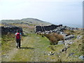
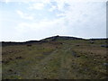
Situated on a level/shelf on an east facing slope the cairn lies partially hidden by tall marsh grasses.
This is a well preserved burial cairn with an array of upright slabs of stone, the tallest about 0.6m in height adorning the circumference like a mini Bryn Cader Faner. I counted 10 uprights of various sizes. The cairn has a 5m diameter and it is almost completely round. The central cist is equally well preserved measuring about 1m by 0.6m. This is a lovely little monument and I'm pleased to include it on this site.
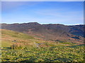
The cairn's location provides for extensive views of the Cwm Mawr valley over towards Cwm Buchan and Bwlch Tyddiad.
You may be viewing yesterday's version of this page. To see the most up to date information please register for a free account.
")
")
")
")
Do not use the above information on other web sites or publications without permission of the contributor.
Nearby Images from Geograph Britain and Ireland:
©2014(licence)
©2015(licence)
©2009(licence)
©2007(licence)
©2015(licence)
The above images may not be of the site on this page, they are loaded from Geograph.
Please Submit an Image of this site or go out and take one for us!
Click here to see more info for this site
Nearby sites
Key: Red: member's photo, Blue: 3rd party photo, Yellow: other image, Green: no photo - please go there and take one, Grey: site destroyed
Download sites to:
KML (Google Earth)
GPX (GPS waypoints)
CSV (Garmin/Navman)
CSV (Excel)
To unlock full downloads you need to sign up as a Contributory Member. Otherwise downloads are limited to 50 sites.
Turn off the page maps and other distractions
Nearby sites listing. In the following links * = Image available
430m SSW 196° Moel-Y-Gerddi Ancient Village or Settlement (SH63023197)
823m N 4° Cairn East of Llyn y Fedw* Cairn (SH63233320)
1.0km N 356° Settlement North of Llyn y Fedw* Ancient Village or Settlement (SH631334)
1.1km NNE 31° Hut Circle West of Nant Steicyn* Ancient Village or Settlement (SH63733329)
1.3km WNW 285° Moel Goedog Hut Circle* Ancient Village or Settlement (SH6193732739)
1.5km WSW 257° Settlement 500m SE of Moel Goedog* Ancient Village or Settlement (SH617321)
1.6km N 5° Standing Stone South of Afon Eisingrug* Standing Stone (Menhir) (SH63323395)
1.6km WNW 287° Ffridd Fedw* Ancient Village or Settlement (SH616329)
1.7km WSW 259° Settlement 400m SE of Moel Goedog* Ancient Village or Settlement (SH615321)
1.8km W 273° Moel Goedog Hillfort* Hillfort (SH61373251)
1.8km WNW 288° Tyddyn Sion Wyn* Ring Cairn (SH61453300)
1.9km W 266° Hut Circle and Enclosure E of Erw Wen* Ancient Village or Settlement (SH61253230)
2.0km NNW 340° Moel Y Glo Enclosed Hut circles* Ancient Village or Settlement (SH625343)
2.0km NNW 342° Moel y Glo Homestead* Ancient Village or Settlement (SH62573434)
2.1km SSW 207° Hut Circle near Gerddi Bluog* Ancient Village or Settlement (SH62183057)
2.1km W 263° Hut Circle SW Moel Goedog* Ancient Village or Settlement (SH611322)
2.1km W 270° Moel Goedog E* Ring Cairn (SH61053244)
2.1km W 270° Moel Goedog W* Ring Cairn (SH6100332456)
2.1km SW 234° Hut Circle and Enclosure, Moel y Gerddi* Ancient Village or Settlement (SH6138031160)
2.2km NNE 19° Afon Eisingrug Cairns* Barrow Cemetery (SH639344)
2.2km NNE 19° Cairn, S of llyn Caerwych* Round Cairn (SH63943444)
2.2km W 266° Moel Goedog 5* Standing Stone (Menhir) (SH60943229)
2.2km SW 235° Bedd Gorfal* Stone Circle (SH61293114)
2.2km NNE 18° Afon Eisingrug Hut Circle* Ancient Village or Settlement (SH639345)
2.3km W 263° Moel Goedog 4* Standing Stone (Menhir) (SH60893216)
View more nearby sites and additional images


 We would like to know more about this location. Please feel free to add a brief description and any relevant information in your own language.
 Wir möchten mehr über diese Stätte erfahren. Bitte zögern Sie nicht, eine kurze Beschreibung und relevante Informationen in Deutsch hinzuzufügen.
 Nous aimerions en savoir encore un peu sur les lieux. S'il vous plaît n'hesitez pas à ajouter une courte description et tous les renseignements pertinents dans votre propre langue.
 Quisieramos informarnos un poco más de las lugares. No dude en añadir una breve descripción y otros datos relevantes en su propio idioma.