


<< Our Photo Pages >> Fortified hut settlement above Rachub - Hillfort in Wales in Gwynedd
Submitted by Postman on Friday, 22 August 2025 Page Views: 6027
Iron Age and Later PrehistorySite Name: Fortified hut settlement above RachubCountry: Wales County: Gwynedd Type: Hillfort
Nearest Town: Bethesda
Map Ref: SH62826790
Latitude: 53.190445N Longitude: 4.054661W
Condition:
| 5 | Perfect |
| 4 | Almost Perfect |
| 3 | Reasonable but with some damage |
| 2 | Ruined but still recognisable as an ancient site |
| 1 | Pretty much destroyed, possibly visible as crop marks |
| 0 | No data. |
| -1 | Completely destroyed |
| 5 | Superb |
| 4 | Good |
| 3 | Ordinary |
| 2 | Not Good |
| 1 | Awful |
| 0 | No data. |
| 5 | Can be driven to, probably with disabled access |
| 4 | Short walk on a footpath |
| 3 | Requiring a bit more of a walk |
| 2 | A long walk |
| 1 | In the middle of nowhere, a nightmare to find |
| 0 | No data. |
| 5 | co-ordinates taken by GPS or official recorded co-ordinates |
| 4 | co-ordinates scaled from a detailed map |
| 3 | co-ordinates scaled from a bad map |
| 2 | co-ordinates of the nearest village |
| 1 | co-ordinates of the nearest town |
| 0 | no data |
Internal Links:
External Links:
")
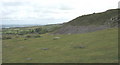
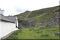
On my visit the sky was a dirty grey, the hills have been quarried away, and the fort is barely there at all anymore. One for the enthusiastic obsessive completist. That's me then.
You may be viewing yesterday's version of this page. To see the most up to date information please register for a free account.
")
")
Do not use the above information on other web sites or publications without permission of the contributor.
Nearby Images from Geograph Britain and Ireland:
©2007(licence)
©2018(licence)
©2018(licence)
©2007(licence)

©2016(licence)
The above images may not be of the site on this page, they are loaded from Geograph.
Please Submit an Image of this site or go out and take one for us!
Click here to see more info for this site
Nearby sites
Key: Red: member's photo, Blue: 3rd party photo, Yellow: other image, Green: no photo - please go there and take one, Grey: site destroyed
Download sites to:
KML (Google Earth)
GPX (GPS waypoints)
CSV (Garmin/Navman)
CSV (Excel)
To unlock full downloads you need to sign up as a Contributory Member. Otherwise downloads are limited to 50 sites.
Turn off the page maps and other distractions
Nearby sites listing. In the following links * = Image available
329m E 90° Cairn cemetery, W. shoulder of Moel Faban* Cairn (SH63156789)
650m S 178° Pen Y Gaer (Bethesda)* Hillfort (SH62826725)
650m S 178° Pen y Gaer* Hillfort (SH62826725)
691m ENE 71° Moel Faban* Cairn (SH63486811)
754m E 96° Moel Faban Arrow Stone* Carving (SH63576780)
818m W 276° Maes Bleddyn Hut Circle Settlement* Ancient Village or Settlement (SH6200768009)
1.0km ENE 62° Bwlch ym Mhwll-le* Cairn (SH63746835)
1.6km NE 53° Hut Circle at Twll Pant Hiriol* Ancient Village or Settlement (SH641688)
1.8km NW 320° Rhiw Goch Enclosed Hut Circle Settlement* Ancient Village or Settlement (SH61696931)
2.5km WSW 246° Sling (Llandegai)* Chambered Tomb (SH60556695)
2.7km WNW 290° Pen Dinas Camp* Hillfort (SH603689)
2.8km NE 48° Moel Wnion (Gwynedd)* Cairn (SH64966971)
3.5km E 87° Drosgl* Cairn (SH663680)
3.7km NE 38° Cairn N of Moel Wnion* Cairn (SH65197071)
3.9km NE 39° Cras (Gwynedd)* Cairn (SH65397089)
4.2km NW 316° Llandegai Bronze Age Settlement* Ancient Village or Settlement (SH600710)
4.2km WSW 243° Carnedd Moel Y Ci* Round Cairn (SH59036608)
4.4km NW 313° Llandegai Cursus Cursus (SH597710)
4.5km WSW 244° Ty'n Llidiard Hut Circle Settlement* Ancient Village or Settlement (SH5873066090)
4.6km NW 311° Llandegai Henge Complex* Henge (SH59407100)
4.6km NW 311° Llandegai Cursus* Cursus (SH594710)
4.6km NE 56° Coed Aber Roundhouse* Ancient Village or Settlement (SH6674570381)
5.2km NE 53° Meuryn Isaf Cairn (SH671709)
5.8km NE 35° Maes Y Gaer* Hillfort (SH663725)
5.9km NE 49° Anafon Valley Cairns* Cairn (SH67397166)
View more nearby sites and additional images


 We would like to know more about this location. Please feel free to add a brief description and any relevant information in your own language.
 Wir möchten mehr über diese Stätte erfahren. Bitte zögern Sie nicht, eine kurze Beschreibung und relevante Informationen in Deutsch hinzuzufügen.
 Nous aimerions en savoir encore un peu sur les lieux. S'il vous plaît n'hesitez pas à ajouter une courte description et tous les renseignements pertinents dans votre propre langue.
 Quisieramos informarnos un poco más de las lugares. No dude en añadir una breve descripción y otros datos relevantes en su propio idioma.