


<< Our Photo Pages >> Ffynnon Peris - Holy Well or Sacred Spring in Wales in Gwynedd
Submitted by KiwiBetsy on Sunday, 21 November 2004 Page Views: 11404
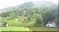
Springs and Holy WellsSite Name: Ffynnon Peris Alternative Name: Saint's Well, Ffynnon Beris, Nant PerisCountry: Wales
NOTE: This site is 1.0 km away from the location you searched for.
County: Gwynedd Type: Holy Well or Sacred Spring
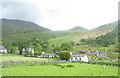
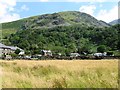
Nearest Town: Llanberis Nearest Village: Nant Peris
Map Ref: SH6084358359
Latitude: 53.104224N Longitude: 4.080082W
Condition:
| 5 | Perfect |
| 4 | Almost Perfect |
| 3 | Reasonable but with some damage |
| 2 | Ruined but still recognisable as an ancient site |
| 1 | Pretty much destroyed, possibly visible as crop marks |
| 0 | No data. |
| -1 | Completely destroyed |
| 5 | Superb |
| 4 | Good |
| 3 | Ordinary |
| 2 | Not Good |
| 1 | Awful |
| 0 | No data. |
| 5 | Can be driven to, probably with disabled access |
| 4 | Short walk on a footpath |
| 3 | Requiring a bit more of a walk |
| 2 | A long walk |
| 1 | In the middle of nowhere, a nightmare to find |
| 0 | No data. |
| 5 | co-ordinates taken by GPS or official recorded co-ordinates |
| 4 | co-ordinates scaled from a detailed map |
| 3 | co-ordinates scaled from a bad map |
| 2 | co-ordinates of the nearest village |
| 1 | co-ordinates of the nearest town |
| 0 | no data |
Internal Links:
External Links:
")
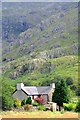
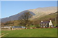
We found Ffynnon Peris in the village of Nant Peris on the Pass of Llanberis road.
In a private garden not far from the church, behind a wrought iron fence and beneath a fine rock outcrop and hawthorn trees was the remains of the old stone wellhouse. Steps still lead down to the water where a slate shelf creates a square pool. Ferns grow out of every crevice and the crystal clear water still looks as if it could support the two trout which legend says would appear to signify that a cure would be wrought. Contributions to the donation box plus 6 shillings and 4 pence formed the salary of the parish clerk back in 1776.
This fine well is dedicated to St Peris who was said to have settled here and drank from it’s waters daily.
Don’t forget to ask permission to visit this well but in fact on the day that we called in 2003, we spoke to a bemused holidaymaker who had rented the cottage on a self catering basis.
You may be viewing yesterday's version of this page. To see the most up to date information please register for a free account.
Do not use the above information on other web sites or publications without permission of the contributor.
Nearby Images from Geograph Britain and Ireland:
©2012(licence)
©2007(licence)
©2014(licence)
©2012(licence)
©2007(licence)
The above images may not be of the site on this page, they are loaded from Geograph.
Please Submit an Image of this site or go out and take one for us!
Click here to see more info for this site
Nearby sites
Key: Red: member's photo, Blue: 3rd party photo, Yellow: other image, Green: no photo - please go there and take one, Grey: site destroyed
Download sites to:
KML (Google Earth)
GPX (GPS waypoints)
CSV (Garmin/Navman)
CSV (Excel)
To unlock full downloads you need to sign up as a Contributory Member. Otherwise downloads are limited to 50 sites.
Turn off the page maps and other distractions
Nearby sites listing. In the following links * = Image available
2.8km WNW 299° Parc Bach* Chambered Tomb (SH5846359778)
4.6km ESE 113° Dyffryn Mymbyr (stone circle)* Stone Circle (SH6505656464)
5.2km ENE 69° Nant Bochllwyd Hut Circle Settlement* Ancient Village or Settlement (SH6577060100)
5.6km WNW 285° Chwarel Fawr Stones* Rock Art (SH5549660004)
5.6km ENE 79° Sion a Siân (Adam and Eve) Stones* Natural Stone / Erratic / Other Natural Feature (SH664593)
6.2km SE 131° Cwm Dyli North settlement* Ancient Village or Settlement (SH65485415)
6.5km WNW 300° Pen-y-bwlch settlement Ancient Village or Settlement (SH55336177)
6.5km NE 48° Carnedd Fach* Cairn (SH6580062620)
6.8km WNW 298° Parc Y Gleision Hut Circle Settlement* Ancient Village or Settlement (SH549617)
6.9km NE 47° Carnedd Dafydd (Conwy)* Cairn (SH661629)
7.0km NE 47° Cairn SW of Carnedd Dafydd* Cairn (SH66136293)
7.0km ESE 122° Nant-y-Llys* Cairn (SH66725450)
7.0km WNW 298° Parc-y-Gleision Standing Stone* Standing Stone (Menhir) (SH54706180)
7.1km WSW 244° Craig Cwmbychan Cairn* Cairn (SH54335542)
7.3km NNW 329° Enclosed Hut Group SW of Cae'r Mynydd* Ancient Village or Settlement (SH57256469)
7.5km NW 314° Cae Corniog Enclosed Hut Group* Ancient Village or Settlement (SH55576368)
7.5km ENE 78° Gwern Gof Isaf* Ancient Village or Settlement (SH68265971)
7.5km WNW 295° Hafodlas Cairn Circle* Cairn (SH54056170)
7.6km SSW 204° Pitt's Head (Cerrig Collwyn)* Natural Stone / Erratic / Other Natural Feature (SH5760651516)
7.8km WSW 240° Mynydd Mawr Cairn* Cairn (SH53965469)
7.9km ESE 102° Dyffryn Mymbyr Round Barrow(s) (SH68565648)
7.9km ESE 102° Dyffryn Mymbyr* Standing Stone (Menhir) (SH68565648)
7.9km NNW 345° Carnedd Moel Y Ci* Round Cairn (SH59036608)
8.0km NNW 328° Coed y Castell Enclosed Hut Circle Settlement* Ancient Village or Settlement (SH5681065230)
8.0km NNW 343° Ty'n Llidiard Hut Circle Settlement* Ancient Village or Settlement (SH5873066090)
View more nearby sites and additional images


 We would like to know more about this location. Please feel free to add a brief description and any relevant information in your own language.
 Wir möchten mehr über diese Stätte erfahren. Bitte zögern Sie nicht, eine kurze Beschreibung und relevante Informationen in Deutsch hinzuzufügen.
 Nous aimerions en savoir encore un peu sur les lieux. S'il vous plaît n'hesitez pas à ajouter une courte description et tous les renseignements pertinents dans votre propre langue.
 Quisieramos informarnos un poco más de las lugares. No dude en añadir una breve descripción y otros datos relevantes en su propio idioma.