<< Our Photo Pages >> Borth Sands Submerged Forest - Natural Stone / Erratic / Other Natural Feature in Wales in Ceredigion

Submitted by coldrum on Wednesday, 27 July 2011  Page Views: 9818

Natural PlacesSite Name: Borth Sands Submerged Forest
Country: Wales County: Ceredigion Type: Natural Stone / Erratic / Other Natural Feature

Map Ref: SN60429255
Latitude: 52.512914N  Longitude: 4.058269W
Condition:
5Perfect
4Almost Perfect
3Reasonable but with some damage
2Ruined but still recognisable as an ancient site
1Pretty much destroyed, possibly visible as crop marks
0No data.
-1Completely destroyed
no data Ambience:
5Superb
4Good
3Ordinary
2Not Good
1Awful
0No data.
no data Access:
5Can be driven to, probably with disabled access
4Short walk on a footpath
3Requiring a bit more of a walk
2A long walk
1In the middle of nowhere, a nightmare to find
0No data.
no data Accuracy:
5co-ordinates taken by GPS or official recorded co-ordinates
4co-ordinates scaled from a detailed map
3co-ordinates scaled from a bad map
2co-ordinates of the nearest village
1co-ordinates of the nearest town
0no data
5
Be the first person to rate this site - see the 'Contribute!' box in the right hand menu.

Internal Links:
External Links:

I have visited· I would like to visit

bat400 would like to visit

Orcinus visited The submerged forest and peat beds extend a little further north and can also be seen at low winter tides in Tywyn on the north side of the Dyfi Estuary

geoffstickland have visited here

Borth Sands Submerged Forest
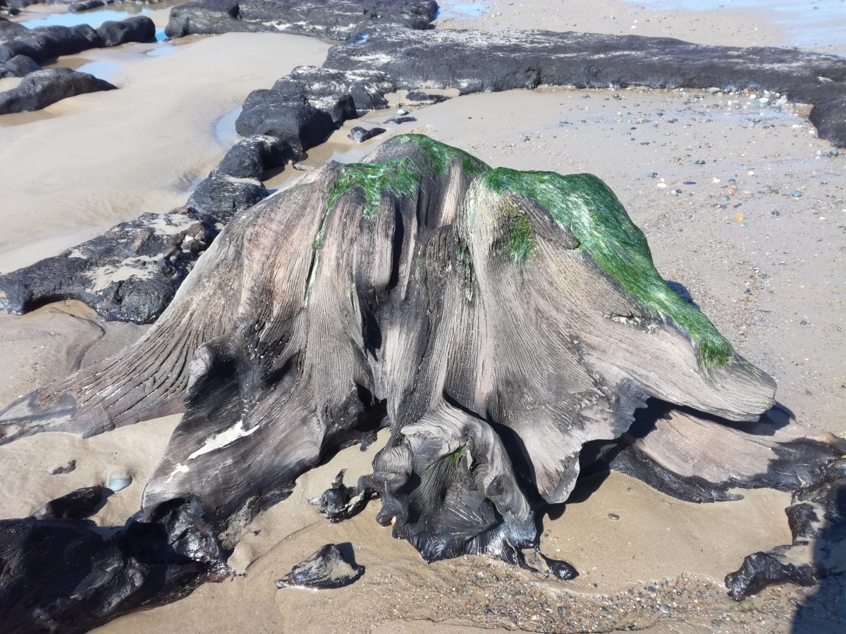
Borth Sands Submerged Forest submitted by geoffstickland : these roots would have been several feet underground when the tree was in its prime (Vote or comment on this photo)
Preserved human footprints in Ceredigion.
Areas of peat with neolithic finds, including human and animal footprints fossilized in the now hardened peat surface, a line of post holes and scatters of burnt stone.

Coflein entry:
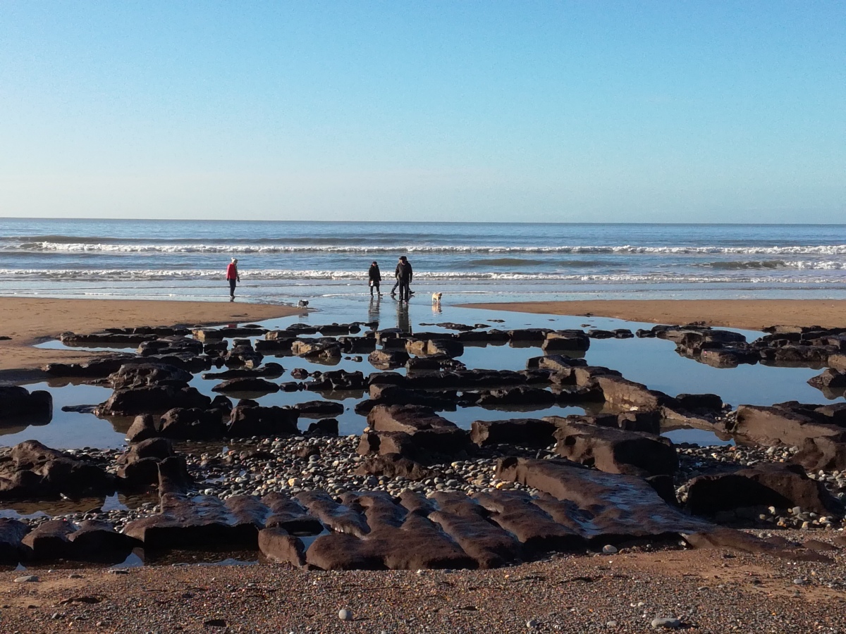
"The submerged forest extends along the beach for some 4.1 km at Borth and Ynyslas. The exposures comprise compacted peat and the stumps and branches of trees. Only small sections are exposed at any one time, most often after heavy winter storms when the covering of sand has been drawn down (e.g. extensive exposures late January - early March 2010).

Event and Histrorical Information:
A survey was undertaken in 1985 by Uinversity of Lampeter accompanied by an analysis of palaeobotanical aspects. The results suggest that the forest florished between 5,000 and 4,500 BP. From 4,800 - 4,000 BP, the area became waterlogged with peat growth, although oaks were growing until 3100 BP at the southern end. A hearth was dated by association with the peat to 4,000 BP. A number of finds have come from the submerged forest - a mesolithic composite tool of antler, two flints, the skeleton of an auroch and a piece of antler."

Source: Royal Commission on the Ancient and Historical Monuments of Wales.
You may be viewing yesterday's version of this page. To see the most up to date information please register for a free account.

Borth Sands Submerged Forest
Borth Sands Submerged Forest submitted by Orcinus : Submerged forest peat beds exposed north of Borth at Tywyn (Vote or comment on this photo)

Borth Sands Submerged Forest
Borth Sands Submerged Forest submitted by Orcinus : part of the submerged forest exposed at Tywyn, north of Borth (Vote or comment on this photo)

Borth Sands Submerged Forest
Borth Sands Submerged Forest submitted by Orcinus : Exposed peat beds at Tywyn (Vote or comment on this photo)

Borth Sands Submerged Forest
Borth Sands Submerged Forest submitted by geoffstickland : ancient root system revealed (Vote or comment on this photo)

Borth Sands Submerged Forest
Borth Sands Submerged Forest submitted by bat400 : Borth Beach Sub Tree, 23 March 2008. Photo by Author Badgernet. This file is licensed under the Creative Commons Attribution-Share Alike 3.0 Unported license.

Borth Sands Submerged Forest
Borth Sands Submerged Forest submitted by geoffstickland : ancient forest revealed at low tide

Do not use the above information on other web sites or publications without permission of the contributor.
Click here to see more info for this site

Nearby sites

Click here to view sites on an interactive OS map

Key: Red: member's photo, Blue: 3rd party photo, Yellow: other image, Green: no photo - please go there and take one, Grey: site destroyed

Download sites to:
KML (Google Earth)
GPX (GPS waypoints)
CSV (Garmin/Navman)
CSV (Excel)

To unlock full downloads you need to sign up as a Contributory Member. Otherwise downloads are limited to 50 sites.


Turn off the page maps and other distractions

Nearby sites listing. In the following links * = Image available
 5.9km S 189° Cerig Y Gath Burial Chamber or Dolmen (SN59378678)
 6.0km SSE 160° St Michael's Church Well Holy Well or Sacred Spring (SN62328687)
 6.4km NNE 20° Happy Valley Tumulus* Round Barrow(s) (SN62809846)
 6.8km SSE 165° Ruel Uchaf Ancient Village or Settlement (SN620859)
 6.8km E 100° Bedd Taliesin* Round Cairn (SN67149121)
 7.3km N 352° Esguan Stone* Standing Stone (Menhir) (SN5961499839)
 7.4km NE 39° Carn March Arthur Stone* Standing Stone (Menhir) (SN6526298167)
 7.7km NE 36° Llyn Barfog Cairn* Cairn (SN65159868)
 7.8km NE 36° Llyn Barfog Stone Standing Stone (Menhir) (SN6521298686)
 8.4km SSE 166° Bow Street* Ancient Village or Settlement (SN6223584325)
 8.5km E 87° Carn Wen (Tre-Taliesin) Cairn (SN689927)
 8.5km SSE 151° Cwrt Enclosure Ancient Village or Settlement (SN64348503)
 8.5km NNW 347° St Cadfan (Tywyn)* Early Christian Sculptured Stone (SH58770094)
 8.6km SSE 159° Hen Gaer Hillfort (SN633844)
 8.9km SSE 165° Gorgerddan Enclosure Ancient Village or Settlement (SN62418387)
 9.0km N 354° Croes Faen* Standing Stone (Menhir) (SH59690154)
 9.0km SSE 166° Gorgerddan Round Barrow(s) (SN62328373)
 9.2km NNE 18° Nant Y Bala Cairn (SH6343301213)
 9.3km SSE 154° Penrhyncoch War Memorial Standing Stone (Menhir) (SN6422984058)
 9.3km SSE 165° Plas Gogerddan* Stone Row / Alignment (SN626835)
 9.3km SSE 165° Plas Gogerddan Barrow* Round Barrow(s) (SN62658348)
 9.4km SE 136° Banc Troed Rhiw Seiri* Ring Cairn (SN6679385583)
 9.6km NE 36° Eglwys Gwyddelod* Stone Circle (SH66260016)
 9.7km SSE 149° Bryntirion Well* Holy Well or Sacred Spring (SN65158407)
 9.7km E 97° Moel y Llyn Stone Circle* Stone Circle (SN7010091160)
View more nearby sites and additional images

<< Hemis Shukpachan cup marked stone

Nab Head (Pembrokeshire) >>

Please add your thoughts on this site

Landscapes of Neolithic Ireland, Cooney

Landscapes of Neolithic Ireland, Cooney

Sponsors

Auto-Translation (Google)

Translate from English into:

"Borth Sands Submerged Forest" | Login/Create an Account | 5 News and Comments
  
Go back to top of page    Comments are owned by the poster. We aren't responsible for their content.
Re: Borth Sands Submerged Forest Exposed by Storm Francis by AngieLake on Friday, 11 September 2020
(User Info | Send a Message)
Just noticed this story in the Daily Mail online:

https://www.dailymail.co.uk/sciencetech/article-8718291/Storm-Francis-uncovers-mythical-Sunken-Kingdom-Wales.html

Some good photos and a map. It's a new site not too far from Borth:

"Petrified woodland remains have been previously found on the beaches at the Welsh town of Borth
But Storm Francis revealed previously unknown ancient trees 13 miles (21km) south in Llanrhystud"
[ Reply to This ]

Re: Borth Sands 4000 yr old Red Deer Skull & Antlers by AngieLake on Friday, 29 April 2016
(User Info | Send a Message)
Very interesting article in D.Mail online today, with stunning photos of the submerged forest on Borth Sands, where 4000 yr old Red Deer antlers have recently been uncovered.
Quote:
"The 4ft-wide antlers belonged to a giant stag which roamed the forest during the Bronze Age, and were laid bare by strong tides on the Cardigan Bay coastline."

Read more: http://www.dailymail.co.uk/news/article-3566100/Deer-skull-antlers-4-000-YEARS-old-walkers-beach-storms-uncovered-ancient-forest.html#ixzz47FTqCLBY

[ Reply to This ]

Re: Borth Sands Submerged Forest by Andy B on Wednesday, 06 April 2016
(User Info | Send a Message)
Forests drowned in ancient memory
Borth, Ceredigion The stumps rise from clots of dark peat lying on boulder-clay and held together by a lattice of blanched roots

Small waves hissed into the pebbled shore, clacked stone against stone as I made my way to the drowned forest. One of many around the coasts of Wales (a particularly fine example lies just beyond the east end of Rhyl’s promenade), that at Borth has become more prominent since storms in 2014 scoured away covering sand, which in time will conceal it again.

http://www.theguardian.com/environment/2016/apr/02/country-diary-forests-drowned-ancient-memory
[ Reply to This ]

Ancient footprints found in peat at Borth beach by bat400 on Monday, 03 December 2012
(User Info | Send a Message)
Archaeologists are racing to record and excavate the find in peat at Borth, which gives a snapshot of a time when the shore lay further west. The team believes the footprints could be 3,000 to 4,000 years old. Staff and students from the University of Wales Trinity St David are carrying out the work.

As well as the footprints, a line of post holes has been found, which could have been a causeway. They lie across an area that would have been salt marsh when the footprints were made.

The Royal Commission on Ancient and Historic Monuments is providing survey support, mapping the extent of the peat and other exposed features.

Submerged forests have been found further north on the beach and nearby in the past. Dr Martin Bates is one of the archaeologists leading the excavation team, and it was his father, retired geologist Denis Bates, who discovered the footprints last month.

Dr Bates told BBC Wales' news website: "My father has had an interest in submerged forests for many years. He was down in February as this part of the beach was very clear.
"For various reasons the patterns of sand movement have been temporarily altered and it means this area of beach has been stripped of sand.

"He noticed the marks and told me they didn't look natural."

He estimates they have a window of a few months to log the discoveries and take samples away for environmental testing before the sands shift again and cover the footprints up.

"What we have never had before is documented evidence of human habitation."

Dr Bates added that there were a range of footprints discovered, including cattle, sheep or goat and possibly a bear. However the one which resonates with him is a print which belonged to a young child.

"We have got a footprint of a four-year-old's foot where we can see the toes and everything. I can stand where this child was standing about 4,000 years ago and even though we would have been seeing different things, the intimacy of that is quite special."

Work in previous years on submerged forests found on the area to the north has established that a forest was growing in the area between 3000 and 2500 BC.

Thanks to coldrum for the link. For more, see http://www.bbc.co.uk.
[ Reply to This ]

Re: Borth Sands Submerged Forest by bat400 on Monday, 03 December 2012
(User Info | Send a Message)
In spring 2012 archaeologists had a short window of opportunity to record, excavate and carry out palaeo-environemntal sampling of a large expanse of peat recently exposed beneath the sands on the beach. The peat together with a number of tree stumps and branches, provided a glimpse at the earlier Prehistoric environment, a time when the sea shore lay further west and this was an area of salt marsh. Of particular interest are the series of human and animal footprints fossilized in the now hardened peat surface, a line of post holes perhaps part of a causeway that once crossed the marsh.

The emergency archaeological work was carried out by staff and students of the School of Archaeology, History and Anthropology at the University of Wales Trinity St David. The Royal Commission has provided survey support, mapping the extents of the peat and other exposed features.

Thanks to coldrum for this link. Read more at Heritage of Wales News
[ Reply to This ]

Your Name: Anonymous [ Register Now ]
Subject:


Add your comment or contribution to this page. Spam or offensive posts are deleted immediately, don't even bother

<<< What is five plus one as a number? (Please type the answer to this question in the little box on the left)
You can also embed videos and other things. For Youtube please copy and paste the 'embed code'.
For Google Street View please include Street View in the text.
Create a web link like this: <a href="https://www.megalithic.co.uk">This is a link</a>  

Allowed HTML is:
<p> <b> <i> <a> <img> <em> <br> <strong> <blockquote> <tt> <li> <ol> <ul> <object> <param> <embed> <iframe>

We would like to know more about this location. Please feel free to add a brief description and any relevant information in your own language.
Wir möchten mehr über diese Stätte erfahren. Bitte zögern Sie nicht, eine kurze Beschreibung und relevante Informationen in Deutsch hinzuzufügen.
Nous aimerions en savoir encore un peu sur les lieux. S'il vous plaît n'hesitez pas à ajouter une courte description et tous les renseignements pertinents dans votre propre langue.
Quisieramos informarnos un poco más de las lugares. No dude en añadir una breve descripción y otros datos relevantes en su propio idioma.