


<< Our Photo Pages >> Castell y Gaer - Hillfort in Wales in Gwynedd
Submitted by Postman on Saturday, 13 October 2012 Page Views: 5958
Iron Age and Later PrehistorySite Name: Castell y GaerCountry: Wales
NOTE: This site is 0.5 km away from the location you searched for.
County: Gwynedd Type: Hillfort
Nearest Town: Barmouth Nearest Village: Llwyngwril
Map Ref: SH593090
Latitude: 52.660410N Longitude: 4.081756W
Condition:
| 5 | Perfect |
| 4 | Almost Perfect |
| 3 | Reasonable but with some damage |
| 2 | Ruined but still recognisable as an ancient site |
| 1 | Pretty much destroyed, possibly visible as crop marks |
| 0 | No data. |
| -1 | Completely destroyed |
| 5 | Superb |
| 4 | Good |
| 3 | Ordinary |
| 2 | Not Good |
| 1 | Awful |
| 0 | No data. |
| 5 | Can be driven to, probably with disabled access |
| 4 | Short walk on a footpath |
| 3 | Requiring a bit more of a walk |
| 2 | A long walk |
| 1 | In the middle of nowhere, a nightmare to find |
| 0 | No data. |
| 5 | co-ordinates taken by GPS or official recorded co-ordinates |
| 4 | co-ordinates scaled from a detailed map |
| 3 | co-ordinates scaled from a bad map |
| 2 | co-ordinates of the nearest village |
| 1 | co-ordinates of the nearest town |
| 0 | no data |
Internal Links:
External Links:
I have visited· I would like to visit
Orcinus would like to visit
")
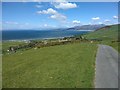
Right by the side of the road south of Llwyngwril. Not the best fort i've ever seen or the best countryside, but it's here and its not going anywhere. Tumbled walls are best seen on the east and south, possible entrance at the north.
You may be viewing yesterday's version of this page. To see the most up to date information please register for a free account.
")
")
Do not use the above information on other web sites or publications without permission of the contributor.
Nearby Images from Geograph Britain and Ireland:

©2012(licence)
©2019(licence)

©2009(licence)

©2012(licence)

©2010(licence)
The above images may not be of the site on this page, they are loaded from Geograph.
Please Submit an Image of this site or go out and take one for us!
Click here to see more info for this site
Nearby sites
Key: Red: member's photo, Blue: 3rd party photo, Yellow: other image, Green: no photo - please go there and take one, Grey: site destroyed
Download sites to:
KML (Google Earth)
GPX (GPS waypoints)
CSV (Garmin/Navman)
CSV (Excel)
To unlock full downloads you need to sign up as a Contributory Member. Otherwise downloads are limited to 50 sites.
Turn off the page maps and other distractions
Nearby sites listing. In the following links * = Image available
1.5km NNE 30° Gwastadgoed* Standing Stones (SH601103)
1.9km ESE 107° Afon Gwril Cairn* Cairn (SH611084)
1.9km NE 37° Cefnfeusydd Farm Cairns* Cairn (SH605105)
2.0km SE 133° Circular Enclosure West of Allt Lwyd* Ancient Village or Settlement (SH607076)
2.0km ESE 121° Cairn West of Allt Lwyd* Cairn (SH610079)
2.1km ESE 102° Afon Gwril Hut Circle Settlement* Ancient Village or Settlement (SH613085)
2.1km ESE 108° Cairn South of Afon Gwril* Cairn (SH613083)
2.1km SE 133° Cairn east of Cae'r Mynach* Cairn (SH608075)
2.1km SE 137° Hut Circles And Enclosure East of Cae'r Mynach* Ancient Village or Settlement (SH607074)
2.5km ESE 117° Allt Lwyd Cairn and Ritual Complex* Cairn (SH615078)
2.5km ESE 119° Cairn and enclosure south of Allt Lwyd* Cairn (SH615077)
3.0km NE 44° Morfa Stone* Standing Stone (Menhir) (SH6144811077)
3.1km E 96° Twll Y Darren Round Barrow(s) (SH624086)
3.3km NE 41° Hut Enclosure and Early Field System South of Mynydd Graigwen* Ancient Village or Settlement (SH615114)
3.3km NE 45° Waun Oer* Stone Row / Alignment (SH61741128)
3.3km S 189° Rhyd y Criw* Standing Stone (Menhir) (SH5868505721)
3.4km NE 39° Gallt Ffynnon Yr Hydd Enclosure* Ancient Village or Settlement (SH615116)
3.5km NE 46° Waun-Oer tomb* Chambered Tomb (SH6192711394)
3.7km SE 145° Glanmachlas Standing Stones* Standing Stones (SH6132905937)
3.9km NE 46° Cairn West of Bryn Seward* Cairn (SH622116)
4.0km S 190° Fron Eunydd Carreg Wen* Standing Stone (Menhir) (SH5851605111)
4.0km SE 128° Tyrgawen* Standing Stone (Menhir) (SH6238106444)
4.1km NE 46° Bryn Seward Probable Cairn* Cairn (SH6231011750)
4.1km NE 51° Bryn Seward Round House and Field System* Ancient Village or Settlement (SH6254111493)
4.1km NE 49° Bryn Seward Cairn 3* Cairn (SH6244811614)
View more nearby sites and additional images


 We would like to know more about this location. Please feel free to add a brief description and any relevant information in your own language.
 Wir möchten mehr über diese Stätte erfahren. Bitte zögern Sie nicht, eine kurze Beschreibung und relevante Informationen in Deutsch hinzuzufügen.
 Nous aimerions en savoir encore un peu sur les lieux. S'il vous plaît n'hesitez pas à ajouter une courte description et tous les renseignements pertinents dans votre propre langue.
 Quisieramos informarnos un poco más de las lugares. No dude en añadir una breve descripción y otros datos relevantes en su propio idioma.