<< Our Photo Pages >> Down Tor North East (Western) - Cairn in England in Devon
Submitted by Anne T on Sunday, 16 October 2016 Page Views: 1507
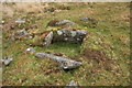
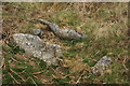
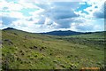
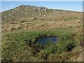
Neolithic and Bronze AgeSite Name: Down Tor North East (Western) Alternative Name: Hingston Hill N2; Grinsell Walkhampton 27; Dixon 107Country: England County: Devon Type: Cairn
Nearest Town: Princetown Nearest Village: Sheepstor
Map Ref: SX5838669565
Latitude: 50.508706N Longitude: 3.998527W
Condition:
| 5 | Perfect |
| 4 | Almost Perfect |
| 3 | Reasonable but with some damage |
| 2 | Ruined but still recognisable as an ancient site |
| 1 | Pretty much destroyed, possibly visible as crop marks |
| 0 | No data. |
| -1 | Completely destroyed |
| 5 | Superb |
| 4 | Good |
| 3 | Ordinary |
| 2 | Not Good |
| 1 | Awful |
| 0 | No data. |
| 5 | Can be driven to, probably with disabled access |
| 4 | Short walk on a footpath |
| 3 | Requiring a bit more of a walk |
| 2 | A long walk |
| 1 | In the middle of nowhere, a nightmare to find |
| 0 | No data. |
| 5 | co-ordinates taken by GPS or official recorded co-ordinates |
| 4 | co-ordinates scaled from a detailed map |
| 3 | co-ordinates scaled from a bad map |
| 2 | co-ordinates of the nearest village |
| 1 | co-ordinates of the nearest town |
| 0 | no data |
Be the first person to rate this site - see the 'Contribute!' box in the right hand menu.
Internal Links:
External Links:
I have visited· I would like to visit
Catrinm visited on 13th May 2022 - their rating: Cond: 3 Amb: 3 Access: 2
 (PID:158981)")
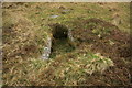
Information for this cist comes from the Prehistoric Dartmoor Walks (PDW) website - see their entry for the Down Tor N.E. (Western) Platform Cairn Circle and Cist, which includes a description, a photograph and links to further information.
This cist is also recorded as part of Pastscape, Monument Number 438861, which tells us this cairn: "(is) standing in the remains of a barrow and retaining circle some 14 ft. in diameter and complete except for the coverstone. The western sidestone is leaning outwards; the eastern is 46 in. long. The average dimensions are: length, 35 in; depth,29 in; original width, between 15 and 21 in. Direction of length, N. 1 1/2 deg W.
The Heritage Gateway for Devon & Dartmoor includes a separate record for this cairn and cist; see HER number MDV3497 (Western of Three Round Cairns 370m east-north-east of Down Tor, Walkhampton).
The cairn and cist is also scheduled as part of Historic England List ID 1010782 (Three round cairns 370m ENE of Down Tor).
You may be viewing yesterday's version of this page. To see the most up to date information please register for a free account.
Do not use the above information on other web sites or publications without permission of the contributor.
Nearby Images from Geograph Britain and Ireland:
©2009(licence)
©2009(licence)
©2009(licence)
©2006(licence)
©2010(licence)
The above images may not be of the site on this page, they are loaded from Geograph.
Please Submit an Image of this site or go out and take one for us!
Click here to see more info for this site
Nearby sites
Key: Red: member's photo, Blue: 3rd party photo, Yellow: other image, Green: no photo - please go there and take one, Grey: site destroyed
Download sites to:
KML (Google Earth)
GPX (GPS waypoints)
CSV (Garmin/Navman)
CSV (Excel)
To unlock full downloads you need to sign up as a Contributory Member. Otherwise downloads are limited to 50 sites.
Turn off the page maps and other distractions
Nearby sites listing. In the following links * = Image available
4m NNE 32° Down Tor North East (Northern)* Cairn (SX5838869568)
11m ESE 104° Down Tor North East (Eastern)* Cairn (SX5839769562)
359m SE 134° Down Tor cairn* Cairn (SX58646931)
416m SE 134° Down Tor circle* Stone Circle (SX58686927)
441m SW 230° Down Tor Cist* Cist (SX58046929)
565m S 177° Down Tor Circular Settlement* Ancient Village or Settlement (SX5840069000)
656m ESE 104° Down Tor stone row* Stone Row / Alignment (SX59026939)
731m E 96° Narrator Brookhead Enclosure* Ancient Village or Settlement (SX5911369471)
815m E 97° Narrator Brookhead Cairn* Cairn (SX5919569446)
825m N 358° Crazy Well Cross* Ancient Cross (SX58387039)
854m S 173° Cuckoo Rock (Dartmoor)* Rock Art (SX5846668715)
1.4km SSW 195° Outholme Newtake* Cist (SX57996827)
1.6km WNW 294° Stan Lake Platform Cairn Circle Cairn (SX56917028)
1.7km NNW 343° Raddick Hill Cist* Cist (SX57937116)
1.8km SSE 168° Leeden (Sheepstor)* Cairn (SX5869267838)
1.9km ESE 120° Eylesbarrow* Barrow Cemetery (SX59976858)
1.9km SSW 205° Yellowmead cairn* Cairn (SX5753167863)
1.9km SSW 197° Yellowmead ring cairn* Ring Cairn (SX57776774)
1.9km SSW 206° Yellowmead row* Multiple Stone Rows / Avenue (SX5748267842)
1.9km SSW 206° Yellowmead* Stone Circle (SX57486784)
2.0km NNW 337° Raddick Hill North* Ancient Village or Settlement (SX57657147)
2.1km W 267° Leather Tor* Cist (SX5631869522)
2.1km NW 318° Stanlake Settlement* Ancient Village or Settlement (SX57057115)
2.1km ENE 78° Siward's Cross* Ancient Cross (SX60456995)
2.2km NNW 340° Hart Tor south row* Stone Row / Alignment (SX57687168)
View more nearby sites and additional images


 We would like to know more about this location. Please feel free to add a brief description and any relevant information in your own language.
 Wir möchten mehr über diese Stätte erfahren. Bitte zögern Sie nicht, eine kurze Beschreibung und relevante Informationen in Deutsch hinzuzufügen.
 Nous aimerions en savoir encore un peu sur les lieux. S'il vous plaît n'hesitez pas à ajouter une courte description et tous les renseignements pertinents dans votre propre langue.
 Quisieramos informarnos un poco más de las lugares. No dude en añadir una breve descripción y otros datos relevantes en su propio idioma.