<< Our Photo Pages >> Fingal's Stone - Standing Stone (Menhir) in Scotland in Perth and Kinross
Submitted by hamish on Tuesday, 26 July 2005 Page Views: 12506
Neolithic and Bronze AgeSite Name: Fingal's Stone Alternative Name: Final's GraveCountry: Scotland County: Perth and Kinross Type: Standing Stone (Menhir)
Nearest Town: Callander Nearest Village: Killin
Map Ref: NN5712933021
Latitude: 56.467593N Longitude: 4.320636W
Condition:
| 5 | Perfect |
| 4 | Almost Perfect |
| 3 | Reasonable but with some damage |
| 2 | Ruined but still recognisable as an ancient site |
| 1 | Pretty much destroyed, possibly visible as crop marks |
| 0 | No data. |
| -1 | Completely destroyed |
| 5 | Superb |
| 4 | Good |
| 3 | Ordinary |
| 2 | Not Good |
| 1 | Awful |
| 0 | No data. |
| 5 | Can be driven to, probably with disabled access |
| 4 | Short walk on a footpath |
| 3 | Requiring a bit more of a walk |
| 2 | A long walk |
| 1 | In the middle of nowhere, a nightmare to find |
| 0 | No data. |
| 5 | co-ordinates taken by GPS or official recorded co-ordinates |
| 4 | co-ordinates scaled from a detailed map |
| 3 | co-ordinates scaled from a bad map |
| 2 | co-ordinates of the nearest village |
| 1 | co-ordinates of the nearest town |
| 0 | no data |
Internal Links:
External Links:
I have visited· I would like to visit
Uralsdaughter visited on 18th Aug 2018 - their rating: Cond: 3 Amb: 4 Access: 4
hamish have visited here
")
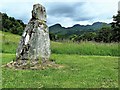
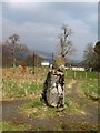
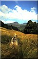
This standing stone can be found in a field behind Killin school. It is recorded as Canmore ID 24192, the 1912 entry of which says: "About 1830 the stone is said to have been higher up the hill, and was brought down because visitors to it damaged the surrounding crop," with a 1978 update which tells us: "This stone stands 0.8m high."
The Northern Antiquarian (TNA) also feature a page for this stone - see their entry for Fingal’s Stone, Killin, Perthshire, which has directions for finding this standings stone, a photograph, a brief archaeology & history and local folklore.
You may be viewing yesterday's version of this page. To see the most up to date information please register for a free account.
")
")
")
Do not use the above information on other web sites or publications without permission of the contributor.
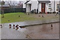
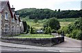
Nearby Images from Geograph Britain and Ireland:
©2019(licence)
©2009(licence)
©2015(licence)
©2008(licence)
©2008(licence)
The above images may not be of the site on this page, they are loaded from Geograph.
Please Submit an Image of this site or go out and take one for us!
Click here to see more info for this site
Nearby sites
Key: Red: member's photo, Blue: 3rd party photo, Yellow: other image, Green: no photo - please go there and take one, Grey: site destroyed
Download sites to:
KML (Google Earth)
GPX (GPS waypoints)
CSV (Garmin/Navman)
CSV (Excel)
To unlock full downloads you need to sign up as a Contributory Member. Otherwise downloads are limited to 50 sites.
Turn off the page maps and other distractions
Nearby sites listing. In the following links * = Image available
479m SSE 167° Innis Bhuidhe* Stone Fort or Dun (NN57223255)
609m ESE 109° Kinnell* Stone Circle (NN5770032803)
1.7km SSW 213° Acharn Standing Stone* Standing Stone (Menhir) (NN56143160)
2.4km NE 44° Tir Artair Standing Stone (Killin) Standing Stone (Menhir) (NN5887034720)
2.6km NE 45° Tir Artair 1 (Killin) Rock Art (NN5906334807)
3.1km ENE 76° Firbush Point (Killin) Hillfort (NN602337)
3.3km WNW 301° Murlaganmore Footprint (Killin) Sculptured Stone (NN54323483)
3.5km NNW 346° Allt na Ceardaich Knoll Rock Art (NN564364)
3.5km WNW 294° Murlaganmore (Killin) Rock Art (NN54023455)
3.5km WNW 294° Murlaganmore 2 (Killin) Rock Art (NN53953455)
3.7km SSW 210° Mid Lix (Killin) Rock Art (NN55132987)
4.2km NNW 348° Creag na Cailleach (Killin) Ancient Mine, Quarry or other Industry (NN56403715)
4.8km WNW 304° Duncroisk* Rock Art (NN53223582)
4.9km WNW 303° Duncroisk 2 (Glen Lochay) Rock Art (NN53133584)
4.9km WNW 303° Corrycharmaig East 4 (Glen Lochay) Rock Art (NN53103582)
5.0km WNW 303° Corrycharmaig East 3 (Glen Lochay) Rock Art (NN5305635877)
5.0km WNW 298° Corrycharmaig 3 (Glen Lochay) Rock Art (NN52783549)
5.1km WNW 302° Corrycharmaig East 2 (Glen Lochay) Rock Art (NN52943588)
5.1km NW 309° Duncroisk Crosses Ancient Cross (NN53253641)
5.2km NW 308° Duncroisk 1 (Glen Lochay) Rock Art (NN53113640)
5.4km NW 306° Tullich Rock Art Rock Art (NN52813634)
5.4km ENE 78° Creag Ard* Rock Art (NN6250433969)
5.5km NW 310° Tirai* Standing Stone (Menhir) (NN53083670)
6.1km NW 307° East Tullich Enclosure (Glen Lochay) Ancient Village or Settlement (NN52363685)
6.4km NNW 328° Duncroisk (Glen Lochay) Hillfort (NN539386)
View more nearby sites and additional images


 We would like to know more about this location. Please feel free to add a brief description and any relevant information in your own language.
 Wir möchten mehr über diese Stätte erfahren. Bitte zögern Sie nicht, eine kurze Beschreibung und relevante Informationen in Deutsch hinzuzufügen.
 Nous aimerions en savoir encore un peu sur les lieux. S'il vous plaît n'hesitez pas à ajouter une courte description et tous les renseignements pertinents dans votre propre langue.
 Quisieramos informarnos un poco más de las lugares. No dude en añadir una breve descripción y otros datos relevantes en su propio idioma.