<< Our Photo Pages >> Trichrug cairns - Round Cairn in Wales in Ceredigion
Submitted by Annafox on Monday, 14 April 2014 Page Views: 2445
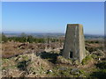
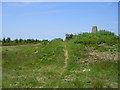
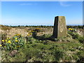
Neolithic and Bronze AgeSite Name: Trichrug cairnsCountry: Wales
NOTE: This site is 2.0 km away from the location you searched for.
County: Ceredigion Type: Round Cairn
Nearest Town: Aberystwyth Nearest Village: Talsarn
Map Ref: SN542599
Latitude: 52.217962N Longitude: 4.135659W
Condition:
| 5 | Perfect |
| 4 | Almost Perfect |
| 3 | Reasonable but with some damage |
| 2 | Ruined but still recognisable as an ancient site |
| 1 | Pretty much destroyed, possibly visible as crop marks |
| 0 | No data. |
| -1 | Completely destroyed |
| 5 | Superb |
| 4 | Good |
| 3 | Ordinary |
| 2 | Not Good |
| 1 | Awful |
| 0 | No data. |
| 5 | Can be driven to, probably with disabled access |
| 4 | Short walk on a footpath |
| 3 | Requiring a bit more of a walk |
| 2 | A long walk |
| 1 | In the middle of nowhere, a nightmare to find |
| 0 | No data. |
| 5 | co-ordinates taken by GPS or official recorded co-ordinates |
| 4 | co-ordinates scaled from a detailed map |
| 3 | co-ordinates scaled from a bad map |
| 2 | co-ordinates of the nearest village |
| 1 | co-ordinates of the nearest town |
| 0 | no data |
Internal Links:
External Links:
I have visited· I would like to visit
rhodct visited on 11th Nov 2023 - their rating: Cond: 3 Amb: 4 Access: 4 Trees regrowing quickly after earlier felling some years ago, panoramic view will be lost
Hayden visited on 15th Apr 2022 - their rating: Cond: 4 Amb: 4 Access: 4 Lovely visit to these mounds with some great views.
rhodct visited on 29th Aug 2020 - their rating: Cond: 3 Amb: 4 Access: 4
Average ratings for this site from all visit loggers: Condition: 3.33 Ambience: 4 Access: 4
")
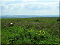
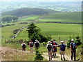
A great view on a clear day and birds sing and the road isn't usually too noisy. A great access for people with small children or people that can't walk far.
It has a great feeling there, of sanctuary.
You may be viewing yesterday's version of this page. To see the most up to date information please register for a free account.
")
")
Do not use the above information on other web sites or publications without permission of the contributor.
Nearby Images from Geograph Britain and Ireland:
©2008(licence)
©2009(licence)
©2015(licence)
©2009(licence)
©2014(licence)
The above images may not be of the site on this page, they are loaded from Geograph.
Please Submit an Image of this site or go out and take one for us!
Click here to see more info for this site
Nearby sites
Key: Red: member's photo, Blue: 3rd party photo, Yellow: other image, Green: no photo - please go there and take one, Grey: site destroyed
Download sites to:
KML (Google Earth)
GPX (GPS waypoints)
CSV (Garmin/Navman)
CSV (Excel)
To unlock full downloads you need to sign up as a Contributory Member. Otherwise downloads are limited to 50 sites.
Turn off the page maps and other distractions
Nearby sites listing. In the following links * = Image available
1.7km SW 233° Castell Perthi-mawr* Hillfort (SN528589)
2.9km SSE 164° Castell Trefilan* Artificial Mound (SN5489557101)
3.9km ESE 112° Pen-Y-Gaer (Nantcwnlle)* Hillfort (SN57735833)
4.3km SW 216° Pen-Y-Gaer (Ceredigion) Hillfort (SN51545648)
4.7km SSE 163° Pen-Clawdd-Mawr Hillfort (SN55455535)
4.9km N 359° Llech Gron* Standing Stone (Menhir) (SN5424664851)
5.3km WNW 296° Castell Dinerth* Promontory Fort / Cliff Castle (SN4949062370)
7.3km NNW 328° Llanon Defended Enclosure* Ancient Village or Settlement (SN5051066250)
7.4km WNW 296° St David's Church Hillfort* Hillfort (SN4761063370)
8.3km WNW 287° Tyn-y-coed the Second Well* Holy Well or Sacred Spring (SN4626462558)
8.3km WNW 287° Tyn-y-coed Well* Holy Well or Sacred Spring (SN4626062559)
8.5km S 182° Cribyn Clota Hillfort (SN53625146)
8.5km S 186° Gaer Fach (Cribyn) Ancient Village or Settlement (SN53135147)
8.5km WSW 237° Cwm Castell Hillfort (SN4694055440)
8.8km N 355° Castell Mawr (Llanrhystud) Hillfort (SN5373068660)
8.8km WNW 286° Aberaeron Chalybeate Well* Holy Well or Sacred Spring (SN458626)
9.0km N 356° Castell Bach (Llanrhystud)* Hillfort (SN5388068870)
9.1km N 356° Pentre-isaf Misc. Earthwork (SN5377069010)
9.1km SSE 158° St Sulien's Church Enclosure Ancient Village or Settlement (SN57445137)
9.1km SSE 160° St Sulien's Church Carved Stone* Early Christian Sculptured Stone (SN5714951242)
9.2km WNW 283° Pant-teg Enclosure* Hillfort (SN4533062300)
9.3km SSW 192° Gaer Maesmynach* Hillfort (SN52005087)
9.4km N 358° Y Foel Promontory Fort * Promontory Fort / Cliff Castle (SN5418069310)
9.5km SE 137° Ffynnon-Wen* Holy Well or Sacred Spring (SN60535283)
9.6km SSE 150° Coed-Parc Gaer Hillfort (SN58795143)
View more nearby sites and additional images


 We would like to know more about this location. Please feel free to add a brief description and any relevant information in your own language.
 Wir möchten mehr über diese Stätte erfahren. Bitte zögern Sie nicht, eine kurze Beschreibung und relevante Informationen in Deutsch hinzuzufügen.
 Nous aimerions en savoir encore un peu sur les lieux. S'il vous plaît n'hesitez pas à ajouter une courte description et tous les renseignements pertinents dans votre propre langue.
 Quisieramos informarnos un poco más de las lugares. No dude en añadir una breve descripción y otros datos relevantes en su propio idioma.