<< Our Photo Pages >> The Three Leaps - Stone Row / Alignment in Wales in Anglesey
Submitted by JackSharp on Friday, 11 April 2008 Page Views: 16943
Neolithic and Bronze AgeSite Name: The Three LeapsCountry: Wales County: Anglesey Type: Stone Row / Alignment
Nearest Town: Menai Bridge Nearest Village: Pentraeth
Map Ref: SH5283878407 Landranger Map Number: 114
Latitude: 53.282150N Longitude: 4.208802W
Condition:
| 5 | Perfect |
| 4 | Almost Perfect |
| 3 | Reasonable but with some damage |
| 2 | Ruined but still recognisable as an ancient site |
| 1 | Pretty much destroyed, possibly visible as crop marks |
| 0 | No data. |
| -1 | Completely destroyed |
| 5 | Superb |
| 4 | Good |
| 3 | Ordinary |
| 2 | Not Good |
| 1 | Awful |
| 0 | No data. |
| 5 | Can be driven to, probably with disabled access |
| 4 | Short walk on a footpath |
| 3 | Requiring a bit more of a walk |
| 2 | A long walk |
| 1 | In the middle of nowhere, a nightmare to find |
| 0 | No data. |
| 5 | co-ordinates taken by GPS or official recorded co-ordinates |
| 4 | co-ordinates scaled from a detailed map |
| 3 | co-ordinates scaled from a bad map |
| 2 | co-ordinates of the nearest village |
| 1 | co-ordinates of the nearest town |
| 0 | no data |
Internal Links:
External Links:
I have visited· I would like to visit
Klingon visited on 24th Oct 2022 - their rating: Cond: 2 Amb: 3 Access: 4 The meadow is completely overgrown with ferns and other undergrowth.
hamish TimPrevett have visited here
")
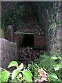
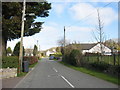
A Pentraeth Legend, The Three Leaps submitted by Jack Sharp
Most people driving past the entrance to Plas Gwyn manor house, on the outskirts of Pentraeth on Anglesey, might well be surprised to learn that they are passing a commemorative monument that has stood there for at least 800 years.
It may not look much like a monument as it is made up of three large boulders grouped together in a narrow field alongside the entrance, but it does mark an event that happened eight centuries ago, and it is known as "The Three Leaps."
There is history attached to these stones, and a touching love story which happened somewhere between 1200 and 1230 AD. The Prince of Wales at the time was Llywelyn the Great.
The Prince had more than one palace in Wales, but a favourite was Aberffraw on Anglesey, where his whole court came to stay from time to time, and to enjoy the hunting and fishing in the area.
He was always accompanied by his elite band of warriors, known in Welsh as "y teulu" (the family). These men had to be of noble birth, but, also, in addition to the usual martial skills, had to achieve a worthwhile deed, or overcome an almost impossible ordeal in order to qualify.
The Prince was fortunate to have by his side an able and astute seneschal (chief steward) called Ednyfed Fychan. His job was to oversee his master's affairs both in and outside the court and he was very highly respected.
Ednyfed was married and had a very beautiful daughter called Angharad. She was just coming up to marriageable age and it was her father's fervent wish that she would marry a man that she loved, and find lasting happiness.
This, in itself, was rather unusual for the time because, in many families, women were not highly regarded. Daughters, in noble families, were used as pawns by marrying them off to men who could either enrich the family coffers, or to seal a bargain, or even to form an advantageous alliance, whatever their age.
Angharad, therefore, was fortunate in having a loving and considerate father in Ednyfed, because she had already fallen in love with Einion, the son of the Lord of Gwalchmai. It was true that Einion was of noble blood, but, as yet, he had not achieved anything really worthwhile.
Ednyfed was aware of this and could see problems ahead. Prince Llywelyn would have to approve of the match, because of Ednyfed's high standing at court, and the most exacting standards would be demanded of any prospective son-in-law. This is where Ednyfed had to be very astute.
He knew that young Einion was a master at an ancient, athletic sport called "Hop, Skip and Jump." This could well be the answer. He set about organising a whole day event, and the chosen venue was a place now called Plas Gwyn in Pentraeth.
It was to be held on the bank of the River Nodwydd, which ran down to the sea at Red Wharf Bay. The eventual winner would win the hand of Angharad.
This particualar athletic event has its equivalent in today's Olympic Games, but it is now called "The Triple Jump", although its origin is Celtic and very old.
When the sons of noble families in the area heard about the contest, they flocked to Plas Gwyn in droves. Each one was eager to prove himeself, knowing that winning Angharad's hand would probably lead to a place in the Prince's "teulu" as well.
The day wore on, with the lengths of the jumps increasing from 15 to 20 feet, then To 30 feet and even to 40 feet. The pace was gruelling, and halfway through many had to give up, weeping with disappointment.
By late afternoon, only a handful remained, with Einion amongst them. They forced themselves to the limit of their endurance.
At last, Einion, with a superhuman effort, succeeded in jumping an unbelievable 50 feet, which none of the others could match. One rival dropped dead with a heart attack in his rage and despair.
So ended a marathon event. Angharad was overjoyed. She could now marry her Einion. Ednyfed too, was content. He had done his duty by his daughter and his Prince.
Three huge boulders were rolled to the site and planted in the ground to commemorate an outstanding "Triple Leap". These stones were investigated some years ago by an archaeological team from Bangor University.
Their antiquity has been confirmed. It was found, also, that similar to icebergs, only one third of each one is above the surface, and two thirds below ground.
The arrangement of the group of stones is not a natural one and, therefore, the conclusion was drawn that they were placed there by man.
Note: Have one of our ancient sites inspired you to write a song or poem? Jack Sharp and his band The Three Stone Cops have just released their debut album, details in the comments
You may be viewing yesterday's version of this page. To see the most up to date information please register for a free account.
")
")
")
")
Do not use the above information on other web sites or publications without permission of the contributor.
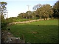
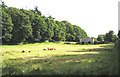
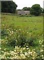
Nearby Images from Geograph Britain and Ireland:
©2005(licence)
©2005(licence)
©2007(licence)
©2016(licence)
©2008(licence)
The above images may not be of the site on this page, they are loaded from Geograph.
Please Submit an Image of this site or go out and take one for us!
Click here to see more info for this site
Nearby sites
Key: Red: member's photo, Blue: 3rd party photo, Yellow: other image, Green: no photo - please go there and take one, Grey: site destroyed
Download sites to:
KML (Google Earth)
GPX (GPS waypoints)
CSV (Garmin/Navman)
CSV (Excel)
To unlock full downloads you need to sign up as a Contributory Member. Otherwise downloads are limited to 50 sites.
![]()
Turn off the page maps and other distractions
Nearby sites listing. In the following links * = Image available
955m E 81° Mynydd Llwydiarth Hillfort (SH5378978520)
1.6km NNE 19° Traeth Coch Pentraeth Standing Stone* Marker Stone (SH534799)
2.0km W 270° Llanddyfynan Barrows* Chambered Tomb (SH5088278462)
2.5km ESE 114° Hendrefor* Chambered Tomb (SH551773)
2.7km W 272° Llanddfynan Standing Stone* Standing Stone (Menhir) (SH5014978592)
3.6km NNW 335° Coed y Glyn Burial Chamber* Chambered Tomb (SH5141381728)
3.9km NNW 343° Caru Benllech Mini Cromlech (modern)* Modern Stone Circle etc (SH5178782173)
3.9km SSW 195° St Gredifael's Holy Well (Penmynydd) Holy Well or Sacred Spring (SH51677465)
4.1km ENE 70° Llanddona* Standing Stone (Menhir) (SH5675879673)
4.2km NNW 344° Benllech Chambered Tomb Chambered Tomb (SH518825)
4.4km NNW 333° Pant-Y-Saer* Chambered Tomb (SH5097182401)
4.4km E 99° Cremlyn 1* Standing Stone (Menhir) (SH572776)
4.6km E 101° Cremlyn 2* Standing Stone (Menhir) (SH573774)
5.0km NNW 332° St Mary (Tynygongl) Ancient Cross (SH50658290)
5.1km SSE 149° Ty-Gwyn* Standing Stone (Menhir) (SH5536273949)
5.7km SE 140° Pen-Y-Maen* Standing Stone (Menhir) (SH564739)
5.9km SW 227° Hirdre-faig* Standing Stone (Menhir) (SH484745)
6.3km S 169° Ty Mawr Tomb* Passage Grave (SH5388672144)
6.5km ENE 60° Din Sylwy* Hillfort (SH586815)
6.6km NW 321° Frigan Field System Misc. Earthwork (SH488837)
6.8km NNW 335° Cae Marh Ancient Village or Settlement (SH5016784694)
7.0km WSW 245° Llangefni Gorsedd Circle Modern Stone Circle etc (SH4636875687)
7.0km NNW 333° Ffynnon Allgo Holy Well or Sacred Spring (SH4989684774)
7.1km NNW 330° Parciau Hillfort Hillfort (SH4945384676)
7.2km WSW 254° Oriel Ynys Mon* Museum (SH458766)
View more nearby sites and additional images


 We would like to know more about this location. Please feel free to add a brief description and any relevant information in your own language.
 Wir möchten mehr über diese Stätte erfahren. Bitte zögern Sie nicht, eine kurze Beschreibung und relevante Informationen in Deutsch hinzuzufügen.
 Nous aimerions en savoir encore un peu sur les lieux. S'il vous plaît n'hesitez pas à ajouter une courte description et tous les renseignements pertinents dans votre propre langue.
 Quisieramos informarnos un poco más de las lugares. No dude en añadir una breve descripción y otros datos relevantes en su propio idioma.