<< Our Photo Pages >> Garnedd Goch Round Cairn - Round Cairn in Wales in Gwynedd
Submitted by TAlanJones on Friday, 16 October 2020 Page Views: 544
Neolithic and Bronze AgeSite Name: Garnedd Goch Round CairnCountry: Wales County: Gwynedd Type: Round Cairn
Nearest Town: Criccieth
Map Ref: SH511495
Latitude: 53.022018N Longitude: 4.2214W
Condition:
| 5 | Perfect |
| 4 | Almost Perfect |
| 3 | Reasonable but with some damage |
| 2 | Ruined but still recognisable as an ancient site |
| 1 | Pretty much destroyed, possibly visible as crop marks |
| 0 | No data. |
| -1 | Completely destroyed |
| 5 | Superb |
| 4 | Good |
| 3 | Ordinary |
| 2 | Not Good |
| 1 | Awful |
| 0 | No data. |
| 5 | Can be driven to, probably with disabled access |
| 4 | Short walk on a footpath |
| 3 | Requiring a bit more of a walk |
| 2 | A long walk |
| 1 | In the middle of nowhere, a nightmare to find |
| 0 | No data. |
| 5 | co-ordinates taken by GPS or official recorded co-ordinates |
| 4 | co-ordinates scaled from a detailed map |
| 3 | co-ordinates scaled from a bad map |
| 2 | co-ordinates of the nearest village |
| 1 | co-ordinates of the nearest town |
| 0 | no data |
Internal Links:
External Links:
")
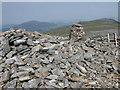
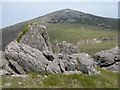
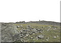
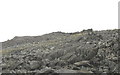
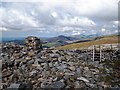
The cairn is situated on the summit of Garnedd Goch a central summit of the ridge between Mynydd Graig Goch to the West and Craig Cwm Silyn to the east. The summit's are the western end of the Nantlle Ridge.
This is a large stone built round cairn with a 16m diameter and a height of 1.5m on the footpath side. There is an estimated height of 3m on the Northern side.
The Nantlle Ridge provides excellent panoramic views.
You may be viewing yesterday's version of this page. To see the most up to date information please register for a free account.
")
")
")
Do not use the above information on other web sites or publications without permission of the contributor.
Nearby Images from Geograph Britain and Ireland:
©2006(licence)
©2006(licence)
©2006(licence)
©2006(licence)
©2015(licence)
The above images may not be of the site on this page, they are loaded from Geograph.
Please Submit an Image of this site or go out and take one for us!
Click here to see more info for this site
Nearby sites
Key: Red: member's photo, Blue: 3rd party photo, Yellow: other image, Green: no photo - please go there and take one, Grey: site destroyed
Download sites to:
KML (Google Earth)
GPX (GPS waypoints)
CSV (Garmin/Navman)
CSV (Excel)
To unlock full downloads you need to sign up as a Contributory Member. Otherwise downloads are limited to 50 sites.
Turn off the page maps and other distractions
Nearby sites listing. In the following links * = Image available
1.6km ENE 62° Craig Cwm Silyn Round Cairn* Round Cairn (SH525502)
1.7km SW 223° Mynydd Graig Goch Round Cairn* Round Cairn (SH499483)
3.3km NE 40° Cwmyffynnon alignment* Natural Stone / Erratic / Other Natural Feature (SH533520)
4.3km NNE 18° Gelli Ffrydiau Hillfort* Hillfort (SH5259053560)
4.6km NW 310° Caer Engan* Hillfort (SH4767052590)
4.6km NW 310° Carreg Caer Engan* Standing Stone (Menhir) (SH4762352591)
4.9km SE 134° Hafod Garregog Cairn 2* Cairn (SH5451645979)
4.9km SE 134° Hafod Garregog Cairn 1* Cairn (SH5453645995)
4.9km SE 134° Hafod Garregog Cairn Cemetery* Barrow Cemetery (SH5450745953)
4.9km SE 135° Hafod Garregog Cairn 3* Cairn (SH5445545902)
4.9km SW 214° The Brynkir Stone Sculptured Stone (SH48214552)
5.0km NNW 342° Mynydd Y Cilgwyn Cairn* Cairn (SH497543)
5.1km NE 50° Y Garn (Gwynedd)* Cairn (SH55135262)
5.2km SE 135° Ceunant y Ddol Hut Circle* Ancient Village or Settlement (SH5466845764)
5.2km SE 142° Ceunant y Ddol Standing Stone* Standing Stone (Menhir) (SH5416845268)
5.4km S 186° Gyrn Goch Cairn* Cairn (SH504441)
5.5km SE 139° Ceunant y Ddol Cemetery Barrow Cemetery (SH5455145269)
5.5km W 268° Graianog Long Mound* Misc. Earthwork (SH45634951)
5.5km SE 140° Ceunant y Ddol Cairn* Cairn (SH5453645167)
5.5km NNW 330° Pen Llwyn Farm Hut Circle Settlement* Ancient Village or Settlement (SH485544)
5.6km W 265° Graianog Standing Stone* Standing Stone (Menhir) (SH45524918)
5.6km NNW 336° Cae Forgan Standing Stone* Standing Stone (Menhir) (SH490547)
5.6km S 181° Castell Caerau* Hillfort (SH508439)
5.6km SE 142° Cairn Cemetery Moel Hebog West Slopes* Barrow Cemetery (SH5442044959)
5.6km S 191° Garndolbenmaen Round Hut* Ancient Village or Settlement (SH499440)
View more nearby sites and additional images


 We would like to know more about this location. Please feel free to add a brief description and any relevant information in your own language.
 Wir möchten mehr über diese Stätte erfahren. Bitte zögern Sie nicht, eine kurze Beschreibung und relevante Informationen in Deutsch hinzuzufügen.
 Nous aimerions en savoir encore un peu sur les lieux. S'il vous plaît n'hesitez pas à ajouter une courte description et tous les renseignements pertinents dans votre propre langue.
 Quisieramos informarnos un poco más de las lugares. No dude en añadir una breve descripción y otros datos relevantes en su propio idioma.