<< Our Photo Pages >> Creetown White Cairn - Cairn in Scotland in Dumfries and Galloway
Submitted by markj99 on Saturday, 17 November 2018 Page Views: 1283
Neolithic and Bronze AgeSite Name: Creetown White Cairn Alternative Name: White CairnCountry: Scotland County: Dumfries and Galloway Type: Cairn
Nearest Town: Creetown
Map Ref: NX49025956
Latitude: 54.907866N Longitude: 4.356514W
Condition:
| 5 | Perfect |
| 4 | Almost Perfect |
| 3 | Reasonable but with some damage |
| 2 | Ruined but still recognisable as an ancient site |
| 1 | Pretty much destroyed, possibly visible as crop marks |
| 0 | No data. |
| -1 | Completely destroyed |
| 5 | Superb |
| 4 | Good |
| 3 | Ordinary |
| 2 | Not Good |
| 1 | Awful |
| 0 | No data. |
| 5 | Can be driven to, probably with disabled access |
| 4 | Short walk on a footpath |
| 3 | Requiring a bit more of a walk |
| 2 | A long walk |
| 1 | In the middle of nowhere, a nightmare to find |
| 0 | No data. |
| 5 | co-ordinates taken by GPS or official recorded co-ordinates |
| 4 | co-ordinates scaled from a detailed map |
| 3 | co-ordinates scaled from a bad map |
| 2 | co-ordinates of the nearest village |
| 1 | co-ordinates of the nearest town |
| 0 | no data |
Internal Links:
External Links:
")
Head for Creetown Gem Rock Museum. Turn R up the hill just before the museum, turn L at the crossroads after 1/4 mile onto a single track road. After 400 yards the Creetown White Cairn is in the field on the R.
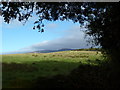
Creetown White Cairn is somewhat of an ironic name as the cairn is a grassy mound with no visible stone structure except for a large stone on the cairn summit. Canmore ID 63303 makes no mention of this stone so it may have been erected post 1970.
It is an unassuming site, on the way to Glenquicken and Cauldside sites so it is worth a short detour.
You may be viewing yesterday's version of this page. To see the most up to date information please register for a free account.
")
Do not use the above information on other web sites or publications without permission of the contributor.
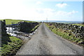
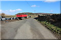
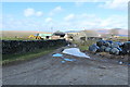
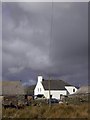
Nearby Images from Geograph Britain and Ireland:
©2015(licence)
©2015(licence)
©2015(licence)
©2009(licence)
©2013(licence)
The above images may not be of the site on this page, they are loaded from Geograph.
Please Submit an Image of this site or go out and take one for us!
Click here to see more info for this site
Nearby sites
Key: Red: member's photo, Blue: 3rd party photo, Yellow: other image, Green: no photo - please go there and take one, Grey: site destroyed
Download sites to:
KML (Google Earth)
GPX (GPS waypoints)
CSV (Garmin/Navman)
CSV (Excel)
To unlock full downloads you need to sign up as a Contributory Member. Otherwise downloads are limited to 50 sites.
Turn off the page maps and other distractions
Nearby sites listing. In the following links * = Image available
1.4km WSW 249° Creetown Gem Rock Museum* Museum (NX477591)
2.2km ESE 124° Glenquickan N Stone Circle (NX50795830)
2.2km SE 127° Glenquicken Cist* Cairn (NX50785815)
2.3km NW 321° Knockglass Cairn* Cairn (NX47656140)
2.4km ESE 123° Glenquicken Circle* Stone Circle (NX50965821)
2.7km ESE 109° Glenquicken Stone* Standing Stone (Menhir) (NX51575858)
3.2km SSE 164° Bagbie stones* Standing Stones (NX4979956401)
3.3km SSE 164° Bagbie cairn* Cairn (NX49795639)
3.3km SSE 164° Bagbie Four Poster* Stone Circle (NX49815638)
3.3km SSE 165° Bagbie Wall Stone* Standing Stone (Menhir) (NX49795635)
3.4km S 185° Kirkmabreck* Rock Art (NX48625620)
3.4km SSE 165° Standing Stone of Bagbie* Standing Stone (Menhir) (NX4977456200)
3.9km SSE 158° Knock Gray Standing Stone* Standing Stone (Menhir) (NX5037055881)
4.3km ESE 117° Cambret Moor Cairn* Cairn (NX52815744)
4.4km ESE 118° Penny Stone (Cambret Moor)* Rock Art (NX52855738)
4.5km SE 140° Claughreid* Stone Circle (NX5177356005)
4.5km ESE 119° Caulside Burn Cairn North* Cairn (NX52905725)
4.5km ESE 119° Caulside Burn Stone Setting Stone Row / Alignment (NX52915722)
4.6km ESE 120° Caulside Burn Cairn South* Cairn (NX52945714)
4.6km ESE 120° Cauldside Burn Stone Circle* Stone Circle (NX52955711)
5.4km SSE 147° Cairnholy 6* Rock Art (NX51855496)
5.4km SSE 150° Cairnholy 5* Rock Art (NX51615480)
5.5km SE 127° Cairnharrow Summit* Cairn (NX53335610)
5.5km SSE 151° Cairnholy 4* Rock Art (NX51555463)
5.7km ESE 117° Cairnharrow Cup & Ring Marked Stone* Rock Art (NX54005684)
View more nearby sites and additional images


 We would like to know more about this location. Please feel free to add a brief description and any relevant information in your own language.
 Wir möchten mehr über diese Stätte erfahren. Bitte zögern Sie nicht, eine kurze Beschreibung und relevante Informationen in Deutsch hinzuzufügen.
 Nous aimerions en savoir encore un peu sur les lieux. S'il vous plaît n'hesitez pas à ajouter une courte description et tous les renseignements pertinents dans votre propre langue.
 Quisieramos informarnos un poco más de las lugares. No dude en añadir una breve descripción y otros datos relevantes en su propio idioma.