


<< Our Photo Pages >> Kyle of Durness Wheelhouse - Broch or Nuraghe in Scotland in Sutherland
Submitted by andy_h on Tuesday, 02 March 2004 Page Views: 12203
Iron Age and Later PrehistorySite Name: Kyle of Durness Wheelhouse Alternative Name: Tigh na Fiarnan, Tigh na FiarnainCountry: Scotland County: Sutherland Type: Broch or Nuraghe
Nearest Town: Durness Nearest Village: Laid
Map Ref: NC4048761009 Landranger Map Number: 9
Latitude: 58.507947N Longitude: 4.73959W
Condition:
| 5 | Perfect |
| 4 | Almost Perfect |
| 3 | Reasonable but with some damage |
| 2 | Ruined but still recognisable as an ancient site |
| 1 | Pretty much destroyed, possibly visible as crop marks |
| 0 | No data. |
| -1 | Completely destroyed |
| 5 | Superb |
| 4 | Good |
| 3 | Ordinary |
| 2 | Not Good |
| 1 | Awful |
| 0 | No data. |
| 5 | Can be driven to, probably with disabled access |
| 4 | Short walk on a footpath |
| 3 | Requiring a bit more of a walk |
| 2 | A long walk |
| 1 | In the middle of nowhere, a nightmare to find |
| 0 | No data. |
| 5 | co-ordinates taken by GPS or official recorded co-ordinates |
| 4 | co-ordinates scaled from a detailed map |
| 3 | co-ordinates scaled from a bad map |
| 2 | co-ordinates of the nearest village |
| 1 | co-ordinates of the nearest town |
| 0 | no data |
Internal Links:
External Links:
")
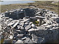
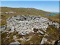
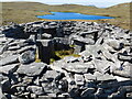
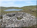
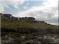
A beautifully located wheelhouse in the hills above Laid, near Durness, Sutherland. Not easily accessible as it is high in the hills.
It's well worth the uphill slog to get to this place. Follow the stream uphill which tumbles down to the road in a set of stepped waterfalls (think it's next to Laid postbox). Eventually you come to a small rocky valley on your right as the hill levels out a little, climb up the left-hand bank to an outcrop, n' there it is below you!
Canmore ref: https://canmore.org.uk/site/4972/meall-meadhonach-loch-eriboll
You may be viewing yesterday's version of this page. To see the most up to date information please register for a free account.
")
")
Do not use the above information on other web sites or publications without permission of the contributor.
Nearby Images from Geograph Britain and Ireland:
©2011(licence)
©2022(licence)
©2022(licence)
©2011(licence)
©2011(licence)
The above images may not be of the site on this page, they are loaded from Geograph.
Please Submit an Image of this site or go out and take one for us!
Click here to see more info for this site
Nearby sites
Key: Red: member's photo, Blue: 3rd party photo, Yellow: other image, Green: no photo - please go there and take one, Grey: site destroyed
Download sites to:
KML (Google Earth)
GPX (GPS waypoints)
CSV (Garmin/Navman)
CSV (Excel)
To unlock full downloads you need to sign up as a Contributory Member. Otherwise downloads are limited to 50 sites.
Turn off the page maps and other distractions
Nearby sites listing. In the following links * = Image available
2.3km E 81° Laid Souterrain (Fogou, Earth House) (NC42816126)
3.6km WNW 289° Ach A' Chorrain Chambered Cairn Chambered Cairn (NC37156233)
3.8km WNW 301° Kyle of Durness Cairn* Round Cairn (NC37336312)
3.9km W 275° Ach A' Chorrain Cairn* Cairn (NC36656149)
4.2km NW 320° Sarsgrum* Cairn (NC37926435)
4.3km W 281° River Dionard Broch or Nuraghe (NC36336200)
4.3km ESE 105° Dun Neachdie Broch or Nuraghe (NC446597)
5.0km E 94° Heilam Hut Circle (4) Cairn (NC45426042)
5.1km SE 124° Camus An Duin Broch or Nuraghe (NC44595797)
5.4km E 93° Heilam Hut Circle (3) Cairn (NC45876052)
5.4km E 95° Heilam Hut Circle (2) Cairn (NC45896036)
5.5km E 96° Heilam Hut Circle (1) Cairn (NC45916026)
5.5km E 92° Heilam Broch* Broch or Nuraghe (NC46026056)
6.3km N 11° Smoo Cave* Cave or Rock Shelter (NC4188367123)
6.4km NNW 346° Balnakeil Stone Circle* Stone Circle (NC392673)
6.7km ESE 105° Arnaboll Hut Circle (2) Cairn (NC46895903)
6.7km E 87° Weirs Hut Circle (2) Cairn (NC47236104)
6.7km ESE 106° Arnaboll Hut Circle (1) Cairn (NC46915893)
6.8km E 90° Weirs Hut Circle (1) Cairn (NC47276079)
7.0km ESE 112° Arnaboll Cairn Cairn (NC46875806)
7.5km ESE 114° Lochside Cairn Cairn (NC47265772)
8.3km SE 124° Creagan na Speireig Cairn (NC47205603)
16.2km ENE 77° West Strathan Carving (Melness) Rock Art (NC5642864084)
16.2km ENE 77° West Strathan* Broch or Nuraghe (NC56456401)
16.7km ESE 118° Kinloch Chambered Cairn Chambered Cairn (NC54975262)
View more nearby sites and additional images


 We would like to know more about this location. Please feel free to add a brief description and any relevant information in your own language.
 Wir möchten mehr über diese Stätte erfahren. Bitte zögern Sie nicht, eine kurze Beschreibung und relevante Informationen in Deutsch hinzuzufügen.
 Nous aimerions en savoir encore un peu sur les lieux. S'il vous plaît n'hesitez pas à ajouter une courte description et tous les renseignements pertinents dans votre propre langue.
 Quisieramos informarnos un poco más de las lugares. No dude en añadir una breve descripción y otros datos relevantes en su propio idioma.