<< Our Photo Pages >> Sarsgrum - Cairn in Scotland in Sutherland
Submitted by markj99 on Monday, 13 September 2021 Page Views: 1068
Neolithic and Bronze AgeSite Name: SarsgrumCountry: Scotland
NOTE: This site is 1.4 km away from the location you searched for.
County: Sutherland Type: Cairn
Nearest Village: Durness
Map Ref: NC37926435
Latitude: 58.536970N Longitude: 4.785967W
Condition:
| 5 | Perfect |
| 4 | Almost Perfect |
| 3 | Reasonable but with some damage |
| 2 | Ruined but still recognisable as an ancient site |
| 1 | Pretty much destroyed, possibly visible as crop marks |
| 0 | No data. |
| -1 | Completely destroyed |
| 5 | Superb |
| 4 | Good |
| 3 | Ordinary |
| 2 | Not Good |
| 1 | Awful |
| 0 | No data. |
| 5 | Can be driven to, probably with disabled access |
| 4 | Short walk on a footpath |
| 3 | Requiring a bit more of a walk |
| 2 | A long walk |
| 1 | In the middle of nowhere, a nightmare to find |
| 0 | No data. |
| 5 | co-ordinates taken by GPS or official recorded co-ordinates |
| 4 | co-ordinates scaled from a detailed map |
| 3 | co-ordinates scaled from a bad map |
| 2 | co-ordinates of the nearest village |
| 1 | co-ordinates of the nearest town |
| 0 | no data |
Internal Links:
External Links:
I have visited· I would like to visit
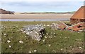
markj99 visited on 3rd Sep 2021 - their rating: Cond: 2 Amb: 3 Access: 4 The main feature of Sarsgrum Cairn is the exposed chamber beside the road which can be viewed on passing. It is possible to park in a passing place c. 100 yards N to have a closer view of the mound.
")
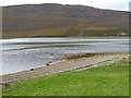
Sarsgrum Chambered Cairn lies on the roadside of the A838 c. 2 miles SW of Durness adjacent to a renovated cottage named after the cairn. According to Canmore ID 4846 Sarsgrum Chambered Cairn had a c. 50 ft diameter but extensive robbing has left an exposed chamber in the E Arc of the cairn. The cairn is turf-covered with small stones exposed on the surface. Sarsgrum Chambered Cairn has a spectacular view of the golden sands of the Kyle of Durness to the NW .
You may be viewing yesterday's version of this page. To see the most up to date information please register for a free account.
")
")
")
Do not use the above information on other web sites or publications without permission of the contributor.
Nearby Images from Geograph Britain and Ireland:
©2015(licence)
©2007(licence)
©2023(licence)
©2014(licence)
©2016(licence)
The above images may not be of the site on this page, they are loaded from Geograph.
Please Submit an Image of this site or go out and take one for us!
Click here to see more info for this site
Nearby sites
Key: Red: member's photo, Blue: 3rd party photo, Yellow: other image, Green: no photo - please go there and take one, Grey: site destroyed
Download sites to:
KML (Google Earth)
GPX (GPS waypoints)
CSV (Garmin/Navman)
CSV (Excel)
To unlock full downloads you need to sign up as a Contributory Member. Otherwise downloads are limited to 50 sites.
Turn off the page maps and other distractions
Nearby sites listing. In the following links * = Image available
1.4km SSW 203° Kyle of Durness Cairn* Round Cairn (NC37336312)
2.2km SSW 198° Ach A' Chorrain Chambered Cairn Chambered Cairn (NC37156233)
2.8km SSW 212° River Dionard Broch or Nuraghe (NC36336200)
3.1km SSW 202° Ach A' Chorrain Cairn* Cairn (NC36656149)
3.2km NNE 21° Balnakeil Stone Circle* Stone Circle (NC392673)
4.2km SE 140° Kyle of Durness Wheelhouse* Broch or Nuraghe (NC4048761009)
4.8km NE 53° Smoo Cave* Cave or Rock Shelter (NC4188367123)
5.8km ESE 120° Laid Souterrain (Fogou, Earth House) (NC42816126)
8.1km ESE 123° Dun Neachdie Broch or Nuraghe (NC446597)
8.4km ESE 115° Heilam Hut Circle (4) Cairn (NC45426042)
8.8km ESE 113° Heilam Hut Circle (3) Cairn (NC45876052)
8.9km ESE 114° Heilam Hut Circle (2) Cairn (NC45896036)
8.9km ESE 113° Heilam Broch* Broch or Nuraghe (NC46026056)
8.9km ESE 115° Heilam Hut Circle (1) Cairn (NC45916026)
9.2km SE 131° Camus An Duin Broch or Nuraghe (NC44595797)
9.8km ESE 107° Weirs Hut Circle (2) Cairn (NC47236104)
10.0km ESE 108° Weirs Hut Circle (1) Cairn (NC47276079)
10.4km ESE 118° Arnaboll Hut Circle (2) Cairn (NC46895903)
10.5km ESE 119° Arnaboll Hut Circle (1) Cairn (NC46915893)
10.9km ESE 123° Arnaboll Cairn Cairn (NC46875806)
11.4km ESE 123° Lochside Cairn Cairn (NC47265772)
12.4km SE 130° Creagan na Speireig Cairn (NC47205603)
18.4km E 88° West Strathan Carving (Melness) Rock Art (NC5642864084)
18.5km E 89° West Strathan* Broch or Nuraghe (NC56456401)
20.6km ESE 121° Dun Mhaigh* Broch or Nuraghe (NC55225303)
View more nearby sites and additional images


 We would like to know more about this location. Please feel free to add a brief description and any relevant information in your own language.
 Wir möchten mehr über diese Stätte erfahren. Bitte zögern Sie nicht, eine kurze Beschreibung und relevante Informationen in Deutsch hinzuzufügen.
 Nous aimerions en savoir encore un peu sur les lieux. S'il vous plaît n'hesitez pas à ajouter une courte description et tous les renseignements pertinents dans votre propre langue.
 Quisieramos informarnos un poco más de las lugares. No dude en añadir una breve descripción y otros datos relevantes en su propio idioma.