<< Our Photo Pages >> Kirriemore - Chambered Cairn in Scotland in Dumfries and Galloway
Submitted by vicky on Wednesday, 25 February 2004 Page Views: 5453
Neolithic and Bronze AgeSite Name: Kirriemore Alternative Name: King's CairnCountry: Scotland County: Dumfries and Galloway Type: Chambered Cairn
Nearest Town: Newton Stewart Nearest Village: Glentrool
Map Ref: NX37738544 Landranger Map Number: 77
Latitude: 55.136657N Longitude: 4.547128W
Condition:
| 5 | Perfect |
| 4 | Almost Perfect |
| 3 | Reasonable but with some damage |
| 2 | Ruined but still recognisable as an ancient site |
| 1 | Pretty much destroyed, possibly visible as crop marks |
| 0 | No data. |
| -1 | Completely destroyed |
| 5 | Superb |
| 4 | Good |
| 3 | Ordinary |
| 2 | Not Good |
| 1 | Awful |
| 0 | No data. |
| 5 | Can be driven to, probably with disabled access |
| 4 | Short walk on a footpath |
| 3 | Requiring a bit more of a walk |
| 2 | A long walk |
| 1 | In the middle of nowhere, a nightmare to find |
| 0 | No data. |
| 5 | co-ordinates taken by GPS or official recorded co-ordinates |
| 4 | co-ordinates scaled from a detailed map |
| 3 | co-ordinates scaled from a bad map |
| 2 | co-ordinates of the nearest village |
| 1 | co-ordinates of the nearest town |
| 0 | no data |
Internal Links:
External Links:
I have visited· I would like to visit
SumDoood would like to visit
")
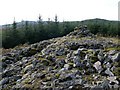
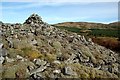
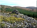
This is a relatively well preserved Bargrennan type chambered cairn, situated on a low knoll on the lower slopes of Kirriemore Hill, about 225 metres above sea level. Despite some stone robbing the cairn remains an impressive monument standing over 3 metres high. The otherwise intact chamber has been burrowed into from the southeast where part of a probable passage has been exposed.
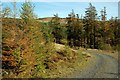
If visiting the site, it is best approached by walking the 2 miles or so along the forestry tracks from the picnic area at NX358866 where you can park. A word of caution, whilst it is possible for a small person to enter the chamber, it is strongly recommended that the attempt is not made as there is a lot of loose & heavy cairn material that could easily fall in if disturbed.
For more information see Canmore ID 63043 which adds that this large circular cairn is about 100 metres in diameter and there is a rudely constructed shepherds pile on top.
You may be viewing yesterday's version of this page. To see the most up to date information please register for a free account.
")
")
Do not use the above information on other web sites or publications without permission of the contributor.
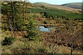
Nearby Images from Geograph Britain and Ireland:
©2009(licence)
©2009(licence)
©2009(licence)
©2009(licence)
©2009(licence)
The above images may not be of the site on this page, they are loaded from Geograph.
Please Submit an Image of this site or go out and take one for us!
Click here to see more info for this site
Nearby sites
Key: Red: member's photo, Blue: 3rd party photo, Yellow: other image, Green: no photo - please go there and take one, Grey: site destroyed
Download sites to:
KML (Google Earth)
GPX (GPS waypoints)
CSV (Garmin/Navman)
CSV (Excel)
To unlock full downloads you need to sign up as a Contributory Member. Otherwise downloads are limited to 50 sites.
Turn off the page maps and other distractions
Nearby sites listing. In the following links * = Image available
2.7km NW 305° Cairnfore* Cairn (NX35548707)
4.2km WSW 246° Sheuchan's Cairn* Chambered Cairn (NX33798387)
6.0km E 97° Grey Man of the Merrick* Natural Stone / Erratic / Other Natural Feature (NX43658450)
7.2km SSW 207° Bargrennan Burn White Cairn* Cairn (NX34227910)
7.5km SSW 197° White Cairn, Bargrennan* Chambered Cairn (NX3524378359)
8.1km E 100° Devil's Bowling Green* Natural Stone / Erratic / Other Natural Feature (NX45658375)
8.2km SW 226° Cairnderry* Chambered Cairn (NX31597993)
8.6km NNE 29° Moss Knowes* Natural Stone / Erratic / Other Natural Feature (NX42239281)
8.8km NNW 338° Pinbreck Hill* Cairn (NX34809371)
9.8km NNW 334° Bencallen Hill* Chambered Cairn (NX33779440)
10.2km S 190° Clachaneasy Bridge* Cairn (NX35647542)
11.3km W 263° Balmalloch Cairnfield* Barrow Cemetery (NX26488439)
11.3km W 263° Balmalloch Chambered Cairn* Chambered Cairn (NX2638784532)
12.3km NW 323° Knockeen Cairn* Cairn (NX30609552)
12.6km WSW 257° Laggan Cairn (Barrhill)* Cairn (NX25358297)
12.8km N 10° Cairnwhapple Stone* Natural Stone / Erratic / Other Natural Feature (NX40399796)
13.2km SW 228° Arnsheen N* Cairn (NX2753877059)
13.2km SW 228° Arnsheen S* Cairn (NX2752777027)
13.9km ENE 63° King's Stone (Carsphairn) Natural Stone / Erratic / Other Natural Feature (NX50419127)
13.9km ENE 63° King's Well (Carsphairn) Holy Well or Sacred Spring (NX5043591268)
14.1km SSE 167° The Thieves* Standing Stones (NX4044071597)
14.1km SSE 147° The Laird's Well (Minnigaff) Holy Well or Sacred Spring (NX4492773263)
14.4km S 169° Drumfern Cairn* Round Cairn (NX39977124)
14.4km SSE 166° Drannandow Chambered Cairn* Chambered Cairn (NX40837135)
14.5km NW 307° Auchensoul Hill* Cairn (NX26399455)
View more nearby sites and additional images


 We would like to know more about this location. Please feel free to add a brief description and any relevant information in your own language.
 Wir möchten mehr über diese Stätte erfahren. Bitte zögern Sie nicht, eine kurze Beschreibung und relevante Informationen in Deutsch hinzuzufügen.
 Nous aimerions en savoir encore un peu sur les lieux. S'il vous plaît n'hesitez pas à ajouter une courte description et tous les renseignements pertinents dans votre propre langue.
 Quisieramos informarnos un poco más de las lugares. No dude en añadir una breve descripción y otros datos relevantes en su propio idioma.