<< Our Photo Pages >> Lagvag Cairn - Cairn in Scotland in Dumfries and Galloway
Submitted by sumdoood on Thursday, 25 December 2014 Page Views: 5496
Neolithic and Bronze AgeSite Name: Lagvag CairnCountry: Scotland
NOTE: This site is 62.1 km away from the location you searched for.
County: Dumfries and Galloway Type: Cairn
Nearest Town: Drummore Nearest Village: Maryport
Map Ref: NX15683044
Latitude: 54.635316N Longitude: 4.857398W
Condition:
| 5 | Perfect |
| 4 | Almost Perfect |
| 3 | Reasonable but with some damage |
| 2 | Ruined but still recognisable as an ancient site |
| 1 | Pretty much destroyed, possibly visible as crop marks |
| 0 | No data. |
| -1 | Completely destroyed |
| 5 | Superb |
| 4 | Good |
| 3 | Ordinary |
| 2 | Not Good |
| 1 | Awful |
| 0 | No data. |
| 5 | Can be driven to, probably with disabled access |
| 4 | Short walk on a footpath |
| 3 | Requiring a bit more of a walk |
| 2 | A long walk |
| 1 | In the middle of nowhere, a nightmare to find |
| 0 | No data. |
| 5 | co-ordinates taken by GPS or official recorded co-ordinates |
| 4 | co-ordinates scaled from a detailed map |
| 3 | co-ordinates scaled from a bad map |
| 2 | co-ordinates of the nearest village |
| 1 | co-ordinates of the nearest town |
| 0 | no data |
Internal Links:
External Links:
")
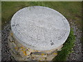
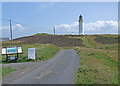
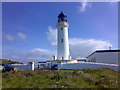
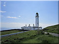
Shown as a "Cairn" on the OS 1:25000 and 50000 maps, it is a round cairn much uglified by the presence of two large water tanks located high on its easterly edge. I assume they contain(ed) water for the lighthouse.
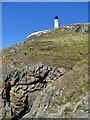
Even if one hadn't been provided, the location at the extreme end of a long peninsula (with wonderful views to the English Lake District, The Isle of Man and Ireland), would demand a cairn.
For further information see Canmore ID 61039 which adds that in 2000, excavations for a water pipe revealed two shallow grooves in the underlying boulder clay on which the cairn lies. These were roughly parallel and aligned from the centre of the cairn. It is thought that these might be ard (plough) marks.
You may be viewing yesterday's version of this page. To see the most up to date information please register for a free account.
")
")
Do not use the above information on other web sites or publications without permission of the contributor.
Nearby Images from Geograph Britain and Ireland:
©2013(licence)
©2018(licence)
©2009(licence)
©2008(licence)
©2012(licence)
The above images may not be of the site on this page, they are loaded from Geograph.
Please Submit an Image of this site or go out and take one for us!
Click here to see more info for this site
Nearby sites
Key: Red: member's photo, Blue: 3rd party photo, Yellow: other image, Green: no photo - please go there and take one, Grey: site destroyed
Download sites to:
KML (Google Earth)
GPX (GPS waypoints)
CSV (Garmin/Navman)
CSV (Excel)
To unlock full downloads you need to sign up as a Contributory Member. Otherwise downloads are limited to 50 sites.
Turn off the page maps and other distractions
Nearby sites listing. In the following links * = Image available
1.2km WNW 288° Mull Of Galloway Earthworks* Ancient Village or Settlement (NX14523086)
1.3km W 280° Mull of Galloway* Ancient Village or Settlement (NX1438130735)
1.7km NW 309° Chapel Wells (Mull of Galloway) Holy Well or Sacred Spring (NX14393159)
2.4km WNW 287° West Cairngaan stone* Standing Stone (Menhir) (NX13393126)
2.7km WNW 293° Kibbertie Kite Well (West Cairngaan) Holy Well or Sacred Spring (NX13193160)
5.0km WNW 291° Eagle Cairn (Cardryne)* Cairn (NX11073246)
5.6km NW 305° Muntloch Well (Drummore) Holy Well or Sacred Spring (NX11153384)
6.3km NNW 335° Lady Well (Low Drummore) Holy Well or Sacred Spring (NX13303626)
7.2km NNW 331° Core Hill* Hillfort (NX12433686)
7.6km WNW 296° Crammag Head* Promontory Fort / Cliff Castle (NX08913404)
7.8km NW 314° Cairn Fell* Cairn (NX10333612)
8.2km NNW 337° Kilstay* Standing Stone (Menhir) (NX1273738072)
10.0km NNW 331° Inchmulloch Hill* Standing Stone (Menhir) (NX1113739421)
10.2km NNW 337° St Bride's Well (Kirkmaiden Parish) Holy Well or Sacred Spring (NX1240)
11.3km NNW 340° Terally Bay* Standing Stone (Menhir) (NX12284127)
12.1km NNW 339° Chipperdingan Well (New England Bay) Holy Well or Sacred Spring (NX11904190)
13.8km NNW 332° St Mary's Well (Logan) Holy Well or Sacred Spring (NX096428)
14.2km NNW 335° Logan House* Standing Stone (Menhir) (NX10224354)
15.6km NNW 327° Grennan Point* Promontory Fort / Cliff Castle (NX07604377)
16.8km NW 326° Doon Castle (Broch)* Broch or Nuraghe (NX0670244683)
18.7km NNW 330° Craigencroy* Cairn (NX07064711)
19.4km NNW 336° Cairnweil standing stone* Standing Stone (Menhir) (NX0863748556)
19.5km NNW 335° Kirkmadrine Church Stones* Early Christian Sculptured Stone (NX0801448389)
20.1km NNW 332° Mid Float E* Standing Stone (Menhir) (NX06804851)
20.1km NNW 331° Mid Float W* Natural Stone / Erratic / Other Natural Feature (NX06584844)
View more nearby sites and additional images


 We would like to know more about this location. Please feel free to add a brief description and any relevant information in your own language.
 Wir möchten mehr über diese Stätte erfahren. Bitte zögern Sie nicht, eine kurze Beschreibung und relevante Informationen in Deutsch hinzuzufügen.
 Nous aimerions en savoir encore un peu sur les lieux. S'il vous plaît n'hesitez pas à ajouter une courte description et tous les renseignements pertinents dans votre propre langue.
 Quisieramos informarnos un poco más de las lugares. No dude en añadir una breve descripción y otros datos relevantes en su propio idioma.